TopoQuest Logo
Do you find TopoQuest useful?
Help keep TopoQuest running and adding new maps/features by donating!
Bitcoin:  19c7KJd3qBynnjoSw5npx9KScwjBe4ifkT
Litecoin:  LXs6TkuXGGXo1vDsWCkWVdjQX94eUKd6ui
Home View Maps Find Maps Find Places Resources & Links


Lyman, Utah Topographic Map

USGS Map Title: Lyman, UT
USGS Map MRC: 38111D5
DRG (GeoTIFF) Download: o38111d5.tif


Neighboring USGS Topographic Map Quads:


  Fish Lake, UT  
38111E6
 

  Forsyth Reservoir, UT  
38111E5
 

  Geyser Peak, UT  
38111E4
 

  Loa, UT  
38111D6
 

  Lyman, UT  
38111D5
 

  Flat Top, UT  
38111D4
 

  Moroni Peak, UT  
38111C6
 

  Bicknell, UT  
38111C5
 

  Torrey, UT  
38111C4


Map MRC Location:

N39°
W112°
N39°
W111°
H8 H7 H6 H5 H4 H3 H2 H1
G8 G7 G6 G5 G4 G3 G2 G1
F8 F7 F6 F5 F4 F3 F2 F1
E8 E7 E6 E5 E4 E3 E2 E1
D8 D7 D6 D5 D4 D3 D2 D1
C8 C7 C6 C5 C4 C3 C2 C1
B8 B7 B6 B5 B4 B3 B2 B1
A8 A7 A6 A5 A4 A3 A2 A1
N38°
W112°
N38°
W111°

Lyman, UT USGS 1:24K Topographic Map Preview:
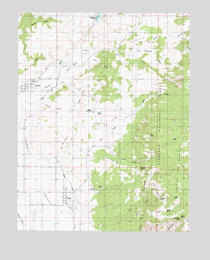
Lyman, UT USGS Topographic Map
Click on map above to begin viewing in our Map Viewer.

This topographic map contains these locations and features:
Feature Name Type Latitude Longitude GNIS ID View Map
Bare SpotFlatN38.3933°W111.5396°1438392View Map
Bare Spot SpringSpringN38.3937°W111.5216°1448105View Map
Bicknell SpringsSpringN38.3866°W111.5129°1448130View Map
Blind LakeLakeN38.4279°W111.5124°1448151View Map
Burnt SpringsSpringN38.4008°W111.5632°1448211View Map
Cedar CreekStreamN38.4214°W111.5568°1439562View Map
Cedar Creek SpringSpringN38.4118°W111.5354°1448246View Map
Clay SpringSpringN38.4303°W111.5288°1448284View Map
Cold SpringSpringN38.3947°W111.5088°1448291View Map
Forsyth ValleyValleyN38.4980°W111.5602°1448415View Map
FremontPopulated PlaceN38.4575°W111.6196°1441231View Map
Fremont BenchBenchN38.4689°W111.5888°1441232View Map
Fremont Census Designated PlaceCensusN38.4554°W111.6150°2629949View Map
Hector HollowValleyN38.4714°W111.5746°1441665View Map
High Line DitchCanalN38.4347°W111.6141°1441755View Map
Highline DitchCanalN38.4089°W111.5921°1450386View Map
Horse PastureFlatN38.3850°W111.5377°1441893View Map
Horse ValleyValleyN38.4247°W111.5699°1441903View Map
Jackson DugwayTrailN38.4497°W111.5321°1442092View Map
Lighah ForkValleyN38.4844°W111.5024°1442581View Map
Lime Kill HollowValleyN38.4150°W111.5993°1442606View Map
Lyges ForkStreamN38.4847°W111.5016°1448632View Map
LymanPopulated PlaceN38.3969°W111.5896°1430020View Map
Lyman CemeteryCemeteryN38.3853°W111.6121°1430021View Map
Lyman Fire DepartmentBuildingN38.3959°W111.5890°2627312View Map
Lyman Post OfficePost OfficeN38.3943°W111.5897°2769069View Map
Mill Meadow DamDamN38.4950°W111.5691°1447715View Map
Mormon ForkValleyN38.4878°W111.5118°1443588View Map
Morrell ForkValleyN38.4861°W111.5102°1443599View Map
Pole CanyonValleyN38.4753°W111.5468°1444527View Map
Red CanyonValleyN38.4789°W111.5552°1444772View Map
Reese CreekStreamN38.4430°W111.5571°1444857View Map
Saddle PassGapN38.3833°W111.5043°1448948View Map
Saddle Pass SpringSpringN38.3827°W111.5072°1448949View Map
Sage FlatFlatN38.4833°W111.5302°1445234View Map
Second LedgesCliffN38.4944°W111.6146°1445404View Map
Sweetwater CreekStreamN38.4778°W111.5366°1449088View Map
Teedee FlatFlatN38.4755°W111.5757°1446368View Map
The Church of Jesus Christ of Latter Day SaintsChurchN38.4569°W111.6185°1449457View Map
The Church of Jesus Christ of Latter Day SaintsChurchN38.3944°W111.5891°1449534View Map
The LedgesCliffN38.4683°W111.6185°1446468View Map
Tidwell ReservoirReservoirN38.4435°W111.5710°1446590View Map
Tidwell SpringSpringN38.4430°W111.5671°1449103View Map
Tidwell ValleyBasinN38.4486°W111.5824°1446592View Map
Town of LymanCivilN38.3966°W111.5893°2412926View Map
Turnbull HollowValleyN38.4480°W111.6110°1446762View Map
Yellow LedgesBarN38.4033°W111.5324°1447557View Map

Note: Coordinates in the location and feature list above are referenced to NAD83 datum.


Copyright (C) 2008-2024 Ryan Niemi / Sunset Dynamics ... All Rights Reserved