TopoQuest Logo
Do you find TopoQuest useful?
Help keep TopoQuest running and adding new maps/features by donating!
Bitcoin:  19c7KJd3qBynnjoSw5npx9KScwjBe4ifkT
Litecoin:  LXs6TkuXGGXo1vDsWCkWVdjQX94eUKd6ui
Home View Maps Find Maps Find Places Resources & Links


Batesville, Mississippi Topographic Map

USGS Map Title: Batesville, MS
USGS Map MRC: 34089C8
DRG (GeoTIFF) Download: o34089c8.tif


Neighboring USGS Topographic Map Quads:


  Pleasant Grove, MS  
34090D1
 

  Sardis, MS  
34089D8
 

  Sardis Dam, MS  
34089D7
 

  Asa, MS  
34090C1
 

  Batesville, MS  
34089C8
 

  Sardis SE, MS  
34089C7
 

  Tocowa, MS  
34090B1
 

  Courtland, MS  
34089B8
 

  Shuford, MS  
34089B7


Map MRC Location:

N35°
W90°
N35°
W89°
H8 H7 H6 H5 H4 H3 H2 H1
G8 G7 G6 G5 G4 G3 G2 G1
F8 F7 F6 F5 F4 F3 F2 F1
E8 E7 E6 E5 E4 E3 E2 E1
D8 D7 D6 D5 D4 D3 D2 D1
C8 C7 C6 C5 C4 C3 C2 C1
B8 B7 B6 B5 B4 B3 B2 B1
A8 A7 A6 A5 A4 A3 A2 A1
N34°
W90°
N34°
W89°

Batesville, MS USGS 1:24K Topographic Map Preview:
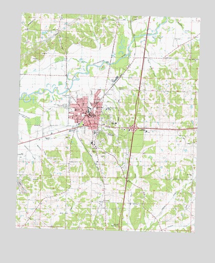
Batesville, MS USGS Topographic Map
Click on map above to begin viewing in our Map Viewer.

This topographic map contains these locations and features:
Feature Name Type Latitude Longitude GNIS ID View Map
American League ParkParkN34.3201°W89.9462°685627View Map
Armstrong Street Church of GodChurchN34.3290°W89.9615°685628View Map
Assembly of God ChurchChurchN34.2890°W89.9634°685629View Map
BatesvillePopulated PlaceN34.3115°W89.9443°666568View Map
Batesville Church of GodChurchN34.3293°W89.9559°685631View Map
Batesville City HallBuildingN34.3182°W89.9526°685632View Map
Batesville Elementary SchoolSchoolN34.3204°W89.9501°707409View Map
Batesville Fire Department Station 1BuildingN34.3173°W89.9532°2665659View Map
Batesville Fire Department Station 2BuildingN34.3090°W89.9297°2665890View Map
Batesville Fire Department Station 3BuildingN34.3381°W89.9200°2665891View Map
Batesville Intermediate SchoolSchoolN34.3209°W89.9512°707410View Map
Batesville Junior High SchoolSchoolN34.3204°W89.9387°707411View Map
Batesville Lookout TowerTowerN34.3084°W89.9112°685633View Map
Batesville Police DepartmentBuildingN34.3182°W89.9516°2754168View Map
Batesville Post OfficePost OfficeN34.3152°W89.9203°2768667View Map
Batesville Presbyterian ChurchChurchN34.3132°W89.9504°685634View Map
Bethlehem ChurchChurchN34.3507°W89.8759°667023View Map
Buck Horn CreekStreamN34.3546°W89.9231°667731View Map
Calvary ChurchChurchN34.3148°W89.9651°692352View Map
Church of ChristChurchN34.3132°W89.9512°685653View Map
City of BatesvilleCivilN34.3147°W89.9249°2403820View Map
Coleman ChurchChurchN34.3226°W89.9601°690966View Map
Cotton Plant ChurchChurchN34.2809°W89.8876°668850View Map
Cotton Plant SchoolSchoolN34.2809°W89.8876°668851View Map
Courtland ChurchChurchN34.2673°W89.9384°685662View Map
First Baptist ChurchChurchN34.3179°W89.9551°685671View Map
First United Methodist ChurchChurchN34.3179°W89.9531°685673View Map
First United Pentecostal Church Revival CenterChurchN34.3148°W89.9620°685674View Map
Interchange 243CrossingN34.3098°W89.9195°691455View Map
Interchange 246CrossingN34.3509°W89.9140°691456View Map
J H McGee Pond DamDamN34.2934°W89.9834°682561View Map
Magnolia CemeteryCemeteryN34.3068°W89.9459°685695View Map
Mississippi Highway Patrol District 3 Troop EBuildingN34.3491°W89.9011°2754306View Map
Mississippi No Name 220 DamDamN34.2634°W89.9868°682540View Map
Mount Zion ChurchChurchN34.3234°W89.9595°685701View Map
Mrs A S Kyle Pond DamDamN34.2984°W89.8868°682566View Map
Noles Landing Strip (historical)AirportN34.2940°W89.9962°1805833View Map
North Batesville Baptist ChurchChurchN34.3393°W89.9395°685705View Map
Panola Country ClubLocaleN34.3059°W89.9368°685710View Map
Panola CountyCivilN34.3639°W89.9506°695776View Map
Panola County AirportAirportN34.3629°W89.8916°680429View Map
Panola County CourthouseBuildingN34.3171°W89.9512°685712View Map
Panola County Sheriff's OfficeBuildingN34.3612°W89.8894°2754104View Map
Patton Lane ParkParkN34.3196°W89.9626°685715View Map
Pilgrim Rest ChurchChurchN34.2851°W89.8768°675763View Map
Pope SchoolSchoolN34.3201°W89.9615°707432View Map
Saint Marys ChurchChurchN34.3293°W89.9387°685734View Map
Saint Paul ChurchChurchN34.3201°W89.9654°685735View Map
Sand CreekStreamN34.3401°W89.9531°685736View Map
Shiloh CemeteryCemeteryN34.2659°W89.9406°1805834View Map
Shiloh ChurchChurchN34.2668°W89.9395°685741View Map
Shoppers Square Shopping CenterLocaleN34.3115°W89.9404°685742View Map
South Panola High SchoolSchoolN34.3209°W89.9373°685745View Map
Southside Church (historical)ChurchN34.2659°W89.9398°685746View Map
Southside School (historical)SchoolN34.2673°W89.9395°685747View Map
Supervisor District 5CivilN34.3198°W89.9889°712021View Map
T A Lemaster Pond DamDamN34.3634°W89.9851°682606View Map
Tallahatchie (historical)LocaleN34.3721°W89.9237°678546View Map
Tri - Lakes Behavioral Health CenterBuildingN34.3125°W89.9322°685744View Map
Tri - Lakes Medical CenterHospitalN34.3061°W89.9147°2672740View Map
Vaughn SchoolSchoolN34.3515°W89.8990°679199View Map
Vaughns ChapelChurchN34.3348°W89.8993°685753View Map
Victory ChurchChurchN34.2771°W89.9393°685754View Map
Viney CreekStreamN34.3468°W89.9423°685755View Map
Viney Creek ChurchChurchN34.3729°W89.9418°679186View Map
WBLE-FM (Batesville)TowerN34.3037°W89.9831°680260View Map
West Camp ChurchChurchN34.3101°W89.9851°679475View Map
WWUN-AM (Batesville)TowerN34.3037°W89.9831°680162View Map

Note: Coordinates in the location and feature list above are referenced to NAD83 datum.


Copyright (C) 2008-2024 Ryan Niemi / Sunset Dynamics ... All Rights Reserved