TopoQuest Logo
Do you find TopoQuest useful?
Help keep TopoQuest running and adding new maps/features by donating!
Bitcoin:  19c7KJd3qBynnjoSw5npx9KScwjBe4ifkT
Litecoin:  LXs6TkuXGGXo1vDsWCkWVdjQX94eUKd6ui
Home View Maps Find Maps Find Places Resources & Links


Livingston, Tennessee Topographic Map

USGS Map Title: Livingston, TN
USGS Map MRC: 36085D3
DRG (GeoTIFF) Download: o36085d3.tif


Neighboring USGS Topographic Map Quads:


  Dale Hollow Dam, TN  
36085E4
 

  Dale Hollow Reservoir SE, TN  
36085E3
 

  Byrdstown, TN  
36085E2
 

  Hilham, TN  
36085D4
 

  Livingston, TN  
36085D3
 

  Alpine, TN  
36085D2
 

  Windle, TN  
36085C4
 

  Okalona, TN  
36085C3
 

  Crawford, TN  
36085C2


Map MRC Location:

N37°
W86°
N37°
W85°
H8 H7 H6 H5 H4 H3 H2 H1
G8 G7 G6 G5 G4 G3 G2 G1
F8 F7 F6 F5 F4 F3 F2 F1
E8 E7 E6 E5 E4 E3 E2 E1
D8 D7 D6 D5 D4 D3 D2 D1
C8 C7 C6 C5 C4 C3 C2 C1
B8 B7 B6 B5 B4 B3 B2 B1
A8 A7 A6 A5 A4 A3 A2 A1
N36°
W86°
N36°
W85°

Livingston, TN USGS 1:24K Topographic Map Preview:
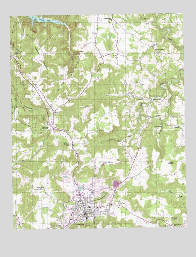
Livingston, TN USGS Topographic Map
Click on map above to begin viewing in our Map Viewer.

This topographic map contains these locations and features:
Feature Name Type Latitude Longitude GNIS ID View Map
A H Roberts SchoolSchoolN36.3873°W85.3169°1315913View Map
AllonsPopulated PlaceN36.4420°W85.3447°1275624View Map
Allons Baptist ChurchChurchN36.4465°W85.3475°1643785View Map
Allons CemeteryCemeteryN36.4467°W85.3472°1644891View Map
Allons Division (historical)CensusN36.4931°W85.3116°1648901View Map
Allons Post OfficePost OfficeN36.4331°W85.3441°2766123View Map
Allons Post Office (historical)Post OfficeN36.4362°W85.3472°1650237View Map
Allons Volunteer Fire and RescueBuildingN36.4368°W85.3454°2654840View Map
Andrew CoveValleyN36.4556°W85.3745°1269304View Map
Big SpringsPopulated PlaceN36.4351°W85.2661°1277423View Map
Cash CemeteryCemeteryN36.3967°W85.3308°1279846View Map
Commissioner District 1CivilN36.3772°W85.3303°2464272View Map
Commissioner District 2CivilN36.4641°W85.3062°2463960View Map
Dillon PondLakeN36.3984°W85.3264°1282480View Map
Elm Grove CemeteryCemeteryN36.3812°W85.3414°1644897View Map
Elm Grove ChurchChurchN36.3812°W85.3414°1283710View Map
Free CommunionPopulated PlaceN36.4820°W85.2727°1647293View Map
Free Communion ChurchChurchN36.4781°W85.2711°1284871View Map
Frenchs Mill (historical)LocaleN36.4501°W85.2750°1315920View Map
Garrett CemeteryCemeteryN36.4787°W85.3691°1285193View Map
Garretts MillPopulated PlaceN36.4265°W85.2983°1315099View Map
Good Hope CemeteryCemeteryN36.3889°W85.2986°1285618View Map
Hall CoveValleyN36.4772°W85.3703°1286586View Map
Herefords Mill (historical)LocaleN36.3778°W85.3400°1315924View Map
Howard ChapelPopulated PlaceN36.4223°W85.2827°1647295View Map
Howard Chapel SchoolSchoolN36.4226°W85.2839°1288534View Map
Hunter CoveValleyN36.4621°W85.3351°1288740View Map
Hunter Cove CemeteryCemeteryN36.4648°W85.3369°1288741View Map
IndependencePopulated PlaceN36.4973°W85.3005°1647296View Map
Independence SchoolSchoolN36.4973°W85.3019°1288927View Map
Keeton PondLakeN36.3845°W85.3071°1289967View Map
Linder MountainSummitN36.4123°W85.2586°1291317View Map
Little Eagle CreekStreamN36.4509°W85.2719°1291486View Map
LivingstonPopulated PlaceN36.3834°W85.3230°1291738View Map
Livingston AcademySchoolN36.3870°W85.3191°1315926View Map
Livingston Division (historical)CensusN36.3837°W85.3144°1648905View Map
Livingston Fire DepartmentBuildingN36.3931°W85.3267°2654364View Map
Livingston First Baptist ChurchChurchN36.3845°W85.3227°1643810View Map
Livingston Middle SchoolSchoolN36.3873°W85.3197°1315927View Map
Livingston Municipal AirportAirportN36.4111°W85.3142°1301425View Map
Livingston Police DepartmentBuildingN36.3930°W85.3265°2765945View Map
Livingston Post OfficePost OfficeN36.3829°W85.3228°1650259View Map
Livingston Regional HospitalHospitalN36.3852°W85.3275°2697315View Map
Long View SchoolSchoolN36.3912°W85.3269°1292015View Map
Memorial Baptist ChurchChurchN36.3917°W85.3261°1643811View Map
Miller CemeteryCemeteryN36.4239°W85.3330°1293933View Map
Miller MountainSummitN36.4240°W85.3377°1293959View Map
Monroe CemeteryCemeteryN36.4348°W85.2513°1644912View Map
Monroe CreekStreamN36.4587°W85.2619°1294175View Map
Nelson CemeteryCemeteryN36.4995°W85.2544°1295377View Map
Nettlecarrier Creek CemeteryCemeteryN36.3942°W85.2533°1644916View Map
Oak GrovePopulated PlaceN36.3759°W85.2616°1315623View Map
Oak Grove 6th SchoolSchoolN36.3753°W85.2577°1296064View Map
Oak Grove Baptist ChurchChurchN36.3756°W85.2583°1643815View Map
Oak Grove MountainSummitN36.3787°W85.2566°1296121View Map
Overton County Ambulance ServiceBuildingN36.3988°W85.3237°2697435View Map
Overton County CourthouseBuildingN36.3834°W85.3227°1326729View Map
Overton County Sheriff's DepartmentBuildingN36.3955°W85.3235°2766052View Map
Overton Plaza Shopping CenterLocaleN36.3806°W85.3333°1315930View Map
Palestine MountainSummitN36.4767°W85.3566°1296686View Map
Reynolds MountainSummitN36.4340°W85.3536°1299262View Map
Richardson CemeteryCemeteryN36.4817°W85.2722°1299341View Map
Schoolhouse MountainSummitN36.3928°W85.3114°1300904View Map
Sells CemeteryCemeteryN36.4939°W85.2750°1301049View Map
Stover CemeteryCemeteryN36.4737°W85.2822°1271557View Map
Sulphur Springs ChurchChurchN36.4498°W85.2739°1271820View Map
Tompkins CoveValleyN36.4557°W85.3742°1272760View Map
Town of LivingstonCivilN36.3877°W85.3270°2406028View Map
UnityPopulated PlaceN36.4787°W85.3252°1273267View Map
Walnut Grove CemeteryCemeteryN36.3984°W85.3555°1644926View Map
Walnut Grove ChurchChurchN36.3987°W85.3555°1273726View Map
Ward (historical)Populated PlaceN36.4892°W85.3652°1643833View Map
White CemeteryCemeteryN36.4598°W85.2852°1274357View Map

Note: Coordinates in the location and feature list above are referenced to NAD83 datum.


Copyright (C) 2008-2024 Ryan Niemi / Sunset Dynamics ... All Rights Reserved