TopoQuest Logo
Do you find TopoQuest useful?
Help keep TopoQuest running and adding new maps/features by donating!
Bitcoin:  19c7KJd3qBynnjoSw5npx9KScwjBe4ifkT
Litecoin:  LXs6TkuXGGXo1vDsWCkWVdjQX94eUKd6ui
Home View Maps Find Maps Find Places Resources & Links


Littlerock, California Topographic Map

USGS Map Title: Littlerock, CA
USGS Map MRC: 34117E8
DRG (GeoTIFF) Download: o34117e8.tif


Neighboring USGS Topographic Map Quads:


  Lancaster East, CA  
34118F1
 

  Alpine Butte, CA  
34117F8
 

  Hi Vista, CA  
34117F7
 

  Palmdale, CA  
34118E1
 

  Littlerock, CA  
34117E8
 

  Lovejoy Buttes, CA  
34117E7
 

  Pacifico Mountain, CA  
34118D1
 

  Juniper Hills, CA  
34117D8
 

  Valyermo, CA  
34117D7


Map MRC Location:

N35°
W118°
N35°
W117°
H8 H7 H6 H5 H4 H3 H2 H1
G8 G7 G6 G5 G4 G3 G2 G1
F8 F7 F6 F5 F4 F3 F2 F1
E8 E7 E6 E5 E4 E3 E2 E1
D8 D7 D6 D5 D4 D3 D2 D1
C8 C7 C6 C5 C4 C3 C2 C1
B8 B7 B6 B5 B4 B3 B2 B1
A8 A7 A6 A5 A4 A3 A2 A1
N34°
W118°
N34°
W117°

Littlerock, CA USGS 1:24K Topographic Map Preview:
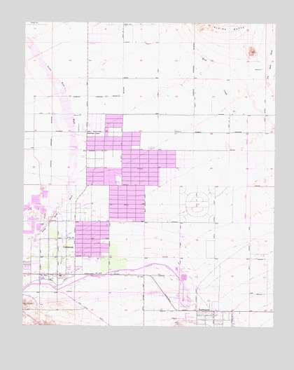
Littlerock, CA USGS Topographic Map
Click on map above to begin viewing in our Map Viewer.

This topographic map contains these locations and features:
Feature Name Type Latitude Longitude GNIS ID View Map
Almondale Middle SchoolSchoolN34.5279°W117.9636°1666836View Map
Alpine Elementary SchoolSchoolN34.5205°W117.9820°1666837View Map
Antelope CenterPopulated PlaceN34.5800°W117.9692°269548View Map
Antelope Elementary SchoolSchoolN34.5589°W117.9527°1666838View Map
Assembly of God ChurchChurchN34.5214°W117.9822°2096762View Map
Avenue T ParkParkN34.5419°W117.9587°1733677View Map
Church of ChristChurchN34.5658°W117.9525°2096757View Map
Church of Jesus Christ of Latter Day SaintsChurchN34.5228°W117.9742°2096763View Map
Cornerstone Church of LittlerockChurchN34.5433°W117.9781°2096760View Map
Daisy Gibson Elementary SchoolSchoolN34.5764°W117.9573°1733680View Map
Everett Martin ParkParkN34.5272°W117.9662°1666850View Map
First Missionary Baptist ChurchChurchN34.5678°W117.9525°2096756View Map
Fountain of the World ChurchChurchN34.5583°W117.9383°2096758View Map
Foursquare Church of PearblossomChurchN34.5031°W117.9100°2096766View Map
Jackie Robinson ParkParkN34.5733°W117.9734°1666853View Map
Jehovah's Witnesses of LittlerockChurchN34.5583°W117.9406°2096764View Map
Little Rock DitchCanalN34.5178°W117.9965°272113View Map
LittlerockPopulated PlaceN34.5211°W117.9837°1660929View Map
Littlerock Branch County of Los Angeles Public LibraryBuildingN34.5214°W117.9840°1763194View Map
Littlerock Census Designated PlaceCensusN34.5232°W117.9808°2408620View Map
Littlerock High SchoolSchoolN34.5738°W117.9388°1666860View Map
Littlerock Post OfficePost OfficeN34.5213°W117.9908°1733684View Map
Littlerock Presbyterian ChurchChurchN34.5208°W117.9883°2096761View Map
Living In Christ Faith MinistryChurchN34.5581°W117.9667°2096759View Map
Los Angeles County Fire Department Station 79BuildingN34.5025°W117.8969°241008View Map
Los Angeles County Fire Department Station 92BuildingN34.5287°W117.9710°2664701View Map
Mountain View SchoolSchoolN34.5194°W117.9823°1666863View Map
PearblossomPopulated PlaceN34.5064°W117.9098°1661204View Map
Pearblossom Arts CenterBuildingN34.5061°W117.8995°1733689View Map
Pearblossom Community Methodist ChurchChurchN34.5061°W117.9056°2096765View Map
Pearblossom District Ranger OfficeLocaleN34.5058°W117.8953°276617View Map
Pearblossom ParkParkN34.5017°W117.9120°1666864View Map
Pearblossom Post OfficePost OfficeN34.5062°W117.9095°1733690View Map
Pearblossom Pumping PlantLocaleN34.5105°W117.9206°1654762View Map
Pearblossom Spilling Basin 1-061 DamDamN34.5200°W117.9209°1663263View Map
Sun Village Census Designated PlaceCensusN34.5596°W117.9556°2583157View Map
Sunset View SchoolSchoolN34.5608°W117.9526°1666868View Map

Note: Coordinates in the location and feature list above are referenced to NAD83 datum.


Copyright (C) 2008-2024 Ryan Niemi / Sunset Dynamics ... All Rights Reserved