TopoQuest Logo
Do you find TopoQuest useful?
Help keep TopoQuest running and adding new maps/features by donating!
Bitcoin:  19c7KJd3qBynnjoSw5npx9KScwjBe4ifkT
Litecoin:  LXs6TkuXGGXo1vDsWCkWVdjQX94eUKd6ui
Home View Maps Find Maps Find Places Resources & Links


Leeds, Alabama Topographic Map

USGS Map Title: Leeds, AL
USGS Map MRC: 33086E5
DRG (GeoTIFF) Download: o33086e5.tif


Neighboring USGS Topographic Map Quads:


  Pinson, AL  
33086F6
 

  Argo, AL  
33086F5
 

  Odenville, AL  
33086F4
 

  Irondale, AL  
33086E6
 

  Leeds, AL  
33086E5
 

  Cooks Springs, AL  
33086E4
 

  Cahaba Heights, AL  
33086D6
 

  Vandiver, AL  
33086D5
 

  Vincent, AL  
33086D4


Map MRC Location:

N34°
W87°
N34°
W86°
H8 H7 H6 H5 H4 H3 H2 H1
G8 G7 G6 G5 G4 G3 G2 G1
F8 F7 F6 F5 F4 F3 F2 F1
E8 E7 E6 E5 E4 E3 E2 E1
D8 D7 D6 D5 D4 D3 D2 D1
C8 C7 C6 C5 C4 C3 C2 C1
B8 B7 B6 B5 B4 B3 B2 B1
A8 A7 A6 A5 A4 A3 A2 A1
N33°
W87°
N33°
W86°

Leeds, AL USGS 1:24K Topographic Map Preview:
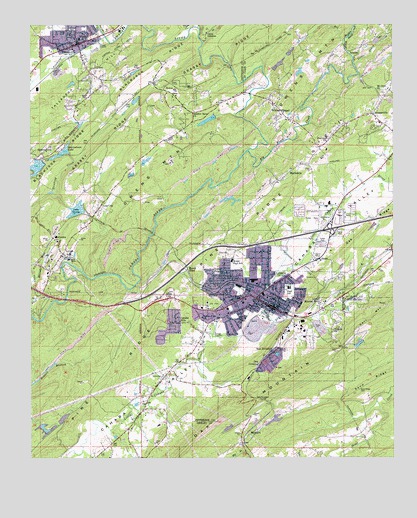
Leeds, AL USGS Topographic Map
Click on map above to begin viewing in our Map Viewer.

This topographic map contains these locations and features:
Feature Name Type Latitude Longitude GNIS ID View Map
Acmar Community ChurchChurchN33.6212°W86.5061°164999View Map
Acton MineMineN33.5904°W86.5347°165001View Map
Adkins Mill (historical)LocaleN33.6040°W86.5050°165002View Map
Austin HillPopulated PlaceN33.5720°W86.5322°165009View Map
Big Black CreekStreamN33.5887°W86.5511°164560View Map
BraggsvillePopulated PlaceN33.5993°W86.5072°164575View Map
Cahaba CovePopulated PlaceN33.6112°W86.5819°144046View Map
Cahaba HillsPopulated PlaceN33.5390°W86.5742°115371View Map
Calaway Slope MineMineN33.5640°W86.5522°165295View Map
Camp ColemanLocaleN33.6226°W86.5658°115450View Map
Cedar Grove (historical)Populated PlaceN33.5237°W86.5789°151597View Map
Cedar Grove Baptist ChurchChurchN33.5579°W86.5278°164599View Map
Cedar Grove CemeteryCemeteryN33.5584°W86.5264°165024View Map
Cedar Grove Post Office (historical)Post OfficeN33.5220°W86.5644°166142View Map
Cedar Springs ParkParkN33.5709°W86.5217°165026View Map
Century Methodist ChurchChurchN33.5429°W86.5522°144076View Map
Church of the Holy CrossChurchN33.6223°W86.6022°144092View Map
City of LeedsCivilN33.5429°W86.5636°2404905View Map
Corinth ChurchChurchN33.6018°W86.5836°144113View Map
Dry CreekStreamN33.5351°W86.5625°164631View Map
Dunnavant Census Designated PlaceCensusN33.5006°W86.5380°2582671View Map
Eades Slope MineMineN33.5612°W86.5522°165294View Map
East Grove Baptist ChurchChurchN33.5423°W86.5244°144145View Map
Fairview Freewill Baptist ChurchChurchN33.5920°W86.5228°164651View Map
First Baptist ChurchChurchN33.6223°W86.6111°154237View Map
First Methodist ChurchChurchN33.5445°W86.5450°154238View Map
First Presbyterian ChurchChurchN33.5443°W86.5469°151347View Map
First Presbyterian Church of TrussvilleChurchN33.6140°W86.6047°154240View Map
First United Methodist ChurchChurchN33.6212°W86.6097°144201View Map
Forest HillsPopulated PlaceN33.5718°W86.5139°165071View Map
Grassy RidgeRidgeN33.6054°W86.5836°164672View Map
Hawkins BranchStreamN33.5851°W86.5458°165086View Map
Heathermoor EstatesPopulated PlaceN33.5701°W86.5319°165087View Map
Henry EllenLocaleN33.5554°W86.5719°119975View Map
Henry Ellen MineMineN33.5612°W86.5972°146222View Map
Heritage ParkPopulated PlaceN33.5709°W86.5055°165089View Map
Hewitt SchoolSchoolN33.6212°W86.6083°144265View Map
Highlandview ChurchChurchN33.6073°W86.5789°144269View Map
Hills Christian Methodist Episcopal ChapelChurchN33.5409°W86.5514°150938View Map
Holy Infant of Prague Catholic ChurchChurchN33.6232°W86.6114°144277View Map
Hundred OaksPopulated PlaceN33.5945°W86.5069°165101View Map
Interchange 140CrossingN33.5448°W86.5930°155736View Map
Interchange 144CrossingN33.5659°W86.5217°165335View Map
James DamDamN33.6118°W86.5433°164938View Map
James LakeReservoirN33.6118°W86.5433°164937View Map
Jones MineMineN33.5834°W86.5694°146221View Map
Kincaid MineMineN33.5668°W86.5522°165296View Map
Lake GeorgeReservoirN33.5718°W86.6091°118905View Map
Lake George DamDamN33.5701°W86.6067°131612View Map
Lake JulesReservoirN33.5116°W86.6141°131584View Map
Lake Jules DamDamN33.5101°W86.6150°131585View Map
LeedsPopulated PlaceN33.5482°W86.5444°152018View Map
Leeds City ParkParkN33.5445°W86.5625°144340View Map
Leeds Civic CenterBuildingN33.5451°W86.5642°144339View Map
Leeds DivisionCivilN33.5093°W86.6141°165821View Map
Leeds Elementary SchoolSchoolN33.5457°W86.5478°144341View Map
Leeds Fire and Rescue Station 1BuildingN33.5584°W86.5222°2683344View Map
Leeds Fire and Rescue Station 2BuildingN33.5415°W86.5408°2682929View Map
Leeds High SchoolSchoolN33.5493°W86.5361°144342View Map
Leeds Mineral WellLocaleN33.5443°W86.5258°121477View Map
Leeds Post OfficePost OfficeN33.5451°W86.5412°2789079View Map
Leeds Presbyterian ChurchChurchN33.5451°W86.5472°144343View Map
Little Black CreekStreamN33.6132°W86.5136°164732View Map
Little Cahaba CreekStreamN33.6240°W86.5686°121725View Map
Lola CityPopulated PlaceN33.5729°W86.6011°121971View Map
LovickPopulated PlaceN33.5590°W86.6139°122067View Map
Macedonia Baptist ChurchChurchN33.5540°W86.5580°144360View Map
MaplewoodPopulated PlaceN33.5390°W86.5528°122272View Map
MarkeetaPopulated PlaceN33.5801°W86.5392°164750View Map
Marketta Baptist ChurchChurchN33.5815°W86.5361°165128View Map
McBreers Slope MineMineN33.5695°W86.5522°165297View Map
McComb FordCrossingN33.5537°W86.6072°154248View Map
McCombsPopulated PlaceN33.5634°W86.6172°156679View Map
McCombs BranchStreamN33.5520°W86.6236°152266View Map
Middle Black CreekStreamN33.6204°W86.5169°164753View Map
Mill RidgeRidgeN33.5301°W86.5455°144382View Map
Miracle Hill ChurchChurchN33.5951°W86.5953°144389View Map
Moody Post OfficePost OfficeN33.5790°W86.5118°2789064View Map
Moore GapGapN33.5312°W86.5175°144404View Map
Moton High SchoolSchoolN33.5570°W86.5564°152391View Map
Mount Nebo CemeteryCemeteryN33.6145°W86.6053°144399View Map
Mount Olive Baptist ChurchChurchN33.6059°W86.5044°164770View Map
Mount Pleasant Baptist ChurchChurchN33.5462°W86.5817°151348View Map
Mountain LakeReservoirN33.5841°W86.6229°144413View Map
Nash DamDamN33.5201°W86.5383°131593View Map
Nash LakeReservoirN33.5201°W86.5383°131592View Map
New Jerusalem ChurchChurchN33.5307°W86.5417°123853View Map
O'Bar BranchStreamN33.5501°W86.5886°144437View Map
O'Bar GapGapN33.5504°W86.5686°154257View Map
Oak CrossingPopulated PlaceN33.5259°W86.5461°124056View Map
Oak Mountain TunnelTunnelN33.5168°W86.5467°124125View Map
Palmers LakeReservoirN33.5977°W86.5639°131625View Map
Pathway Baptist ChurchChurchN33.5504°W86.5408°144448View Map
Pinchgut CreekStreamN33.6198°W86.5983°152907View Map
Pine Ridge Club DamDamN33.5101°W86.6217°131587View Map
Pine Ridge LakeReservoirN33.5079°W86.6201°131586View Map
QueenstownPopulated PlaceN33.5882°W86.6211°125380View Map
Queenstown LakeReservoirN33.5885°W86.6141°125381View Map
Queenstown Lake Number 1 DamDamN33.5851°W86.6200°131620View Map
Queenstown Lake Number 2 DamDamN33.5868°W86.6117°131621View Map
Red Diamond MineMineN33.5390°W86.6042°146223View Map
Ridgewood EstatesPopulated PlaceN33.5945°W86.5180°165177View Map
Riley Slope MineMineN33.5723°W86.5522°165298View Map
RoperPopulated PlaceN33.6065°W86.5803°156994View Map
Roper TunnelTunnelN33.6084°W86.5780°125928View Map
Russell HeightsPopulated PlaceN33.5534°W86.5603°126031View Map
Saint Theresa Catholic ChurchChurchN33.5437°W86.5489°140267View Map
Sand RidgeRidgeN33.5234°W86.5041°126325View Map
Sand Ridge CemeteryCemeteryN33.5195°W86.5116°126327View Map
Schmitt DamDamN33.5101°W86.5550°131582View Map
Schmitt LakeReservoirN33.5088°W86.5570°131583View Map
Scott CityPopulated PlaceN33.5470°W86.5797°126485View Map
Shiloh CemeteryCemeteryN33.5512°W86.5411°151346View Map
Spruell Drift MineMineN33.5557°W86.5522°146220View Map
Stinking CreekStreamN33.5537°W86.6075°127408View Map
Sulphur Springs ChurchChurchN33.6001°W86.5700°127525View Map
Sulphur Springs DamDamN33.5984°W86.5617°131624View Map
Talladega HillSummitN33.6132°W86.6019°153639View Map
Terry Walker Country ClubLocaleN33.5176°W86.5925°140374View Map
Thompson GapGapN33.5173°W86.5472°140340View Map
Tidwell ChurchChurchN33.5368°W86.5208°127965View Map
TrussvillePopulated PlaceN33.6198°W86.6089°153729View Map
Trussville CemeteryCemeteryN33.6212°W86.6041°151349View Map
Trussville DivisionCivilN33.6164°W86.5874°165826View Map
Trussville Fire and Rescue Service Station 1BuildingN33.6207°W86.6033°2683226View Map
Trussville Fire and Rescue Service Station 2BuildingN33.6059°W86.5787°2683215View Map
Trussville ManorPopulated PlaceN33.6029°W86.6167°140350View Map
Trussville Police DepartmentBuildingN33.6207°W86.6032°2751932View Map
Trussville Post OfficePost OfficeN33.6133°W86.6119°2788951View Map
Valley View ChurchChurchN33.5404°W86.5664°128402View Map
Wanderland LakeReservoirN33.5859°W86.5852°140380View Map
Whites ChapelPopulated PlaceN33.5990°W86.5397°164908View Map
Whites Chapel ChurchChurchN33.6245°W86.5275°165330View Map
WinburnPopulated PlaceN33.5082°W86.5469°157269View Map
Woodland VillagePopulated PlaceN33.5684°W86.5180°165226View Map
Zeigler MineMineN33.5529°W86.5522°146219View Map

Note: Coordinates in the location and feature list above are referenced to NAD83 datum.


Copyright (C) 2008-2024 Ryan Niemi / Sunset Dynamics ... All Rights Reserved