TopoQuest Logo
Do you find TopoQuest useful?
Help keep TopoQuest running and adding new maps/features by donating!
Bitcoin:  19c7KJd3qBynnjoSw5npx9KScwjBe4ifkT
Litecoin:  LXs6TkuXGGXo1vDsWCkWVdjQX94eUKd6ui
Home View Maps Find Maps Find Places Resources & Links


Leadville North, Colorado Topographic Map

USGS Map Title: Leadville North, CO
USGS Map MRC: 39106C3
DRG (GeoTIFF) Download: o39106c3.tif


Neighboring USGS Topographic Map Quads:


  Mount of the Holy Cross, CO  
39106D4
 

  Pando, CO  
39106D3
 

  Copper Mountain, CO  
39106D2
 

  Homestake Reservoir, CO  
39106C4
 

  Leadville North, CO  
39106C3
 

  Climax, CO  
39106C2
 

  Mount Massive, CO  
39106B4
 

  Leadville South, CO  
39106B3
 

  Mount Sherman, CO  
39106B2


Map MRC Location:

N40°
W107°
N40°
W106°
H8 H7 H6 H5 H4 H3 H2 H1
G8 G7 G6 G5 G4 G3 G2 G1
F8 F7 F6 F5 F4 F3 F2 F1
E8 E7 E6 E5 E4 E3 E2 E1
D8 D7 D6 D5 D4 D3 D2 D1
C8 C7 C6 C5 C4 C3 C2 C1
B8 B7 B6 B5 B4 B3 B2 B1
A8 A7 A6 A5 A4 A3 A2 A1
N39°
W107°
N39°
W106°

Leadville North, CO USGS 1:24K Topographic Map Preview:
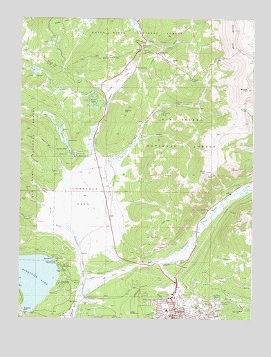
Leadville North, CO USGS Topographic Map
Click on map above to begin viewing in our Map Viewer.

This topographic map contains these locations and features:
Feature Name Type Latitude Longitude GNIS ID View Map
A M MineMineN39.2536°W106.2892°1735926View Map
Adams ShaftMineN39.2505°W106.2736°1684290View Map
Alice PlacerMineN39.2503°W106.2778°1735919View Map
All Right MineMineN39.2572°W106.2859°1735925View Map
American Eagle MineMineN39.2553°W106.2820°1684533View Map
Amity ShaftMineN39.3003°W106.3672°1684291View Map
Baby Doe CampgroundLocaleN39.2697°W106.3511°179891View Map
Bangkok MineMineN39.2575°W106.2672°1735928View Map
Belle of Colorado CampgroundLocaleN39.2683°W106.3495°197462View Map
Big Evans ReservoirReservoirN39.2587°W106.2662°179851View Map
Birdella ShaftMineN39.3039°W106.3711°1684292View Map
Bob Ingersoll MineMineN39.2530°W106.2836°1684293View Map
Buckeye LakeLakeN39.3371°W106.2533°179878View Map
Buckeye MineMineN39.2564°W106.2731°1735927View Map
Buckeye PeakSummitN39.3455°W106.2536°179877View Map
Burton DitchCanalN39.3586°W106.3022°179870View Map
Cady MineMineN39.2636°W106.2734°1735929View Map
Canterbury HillSummitN39.2772°W106.2636°179862View Map
Canterbury Hill MineMineN39.2830°W106.2820°1684294View Map
Capitol Northern MineMineN39.2519°W106.2847°1735930View Map
Chicago RidgeRidgeN39.3703°W106.2611°202667View Map
Chrysolite MineMineN39.2553°W106.2770°1684287View Map
Cooper HillSummitN39.3492°W106.2839°179876View Map
Cora Belle MineMineN39.2564°W106.2695°1735931View Map
Coronado MineMineN39.2536°W106.2892°1735921View Map
Crane ParkFlatN39.3455°W106.3259°179875View Map
Daly MineMineN39.2564°W106.2767°1684295View Map
Delante ShaftMineN39.2547°W106.2872°1684296View Map
Delmonte MineMineN39.2547°W106.2650°1735946View Map
Denver City MineMineN39.2519°W106.2672°1684288View Map
Diamond LakeLakeN39.3173°W106.3444°179885View Map
Dillion MineMineN39.2503°W106.2795°1684297View Map
East Fork Arkansas RiverStreamN39.2569°W106.3439°179861View Map
East Tennessee CreekStreamN39.2861°W106.3464°179880View Map
Elk MineMineN39.2511°W106.2811°1684298View Map
Elkhorn ShaftMineN39.3317°W106.2956°1684299View Map
Evans GulchValleyN39.2727°W106.2994°179860View Map
Evergreen CemeteryCemeteryN39.2511°W106.3050°202686View Map
Fairview HillSummitN39.2544°W106.2786°179865View Map
Fairview Hill MineMineN39.2536°W106.2778°1684300View Map
Fitzhugh MineMineN39.2575°W106.2661°1684301View Map
Fryer HillSummitN39.2550°W106.2728°179853View Map
Fryer Hill MineMineN39.2530°W106.2672°1684302View Map
Gleason GulchValleyN39.2955°W106.3590°179886View Map
Gray Eagle MineMineN39.2544°W106.2825°1735899View Map
Greenback MineMineN39.2503°W106.2695°1684285View Map
Harvard MineMineN39.2586°W106.2700°1684304View Map
Harvard Number One MineMineN39.2575°W106.2686°1735936View Map
Hayden MineMineN39.2519°W106.2722°179855View Map
Hazard MineMineN39.2564°W106.2731°1735935View Map
Hibernia MineMineN39.2528°W106.2742°1684306View Map
Hoffer MineMineN39.2633°W106.2842°1684307View Map
Home LakeLakeN39.3183°W106.3493°204682View Map
Hope MineMineN39.2528°W106.2800°1735934View Map
Huckleberry ShaftMineN39.2992°W106.3725°1684308View Map
Hussy MineMineN39.2519°W106.2800°1684309View Map
Ida Nyce ShaftMineN39.2519°W106.2775°1684310View Map
Island LakeLakeN39.3182°W106.3456°179884View Map
Jamie Lee MineMineN39.2564°W106.2678°1684311View Map
Jason MineMineN39.2564°W106.2847°1735937View Map
Jennie June MineMineN39.3353°W106.3000°179873View Map
Johnson GulchValleyN39.2566°W106.2562°179857View Map
Jones PitMineN39.2725°W106.2978°1684312View Map
Keene ShaftMineN39.2508°W106.2731°1684313View Map
Lady of the Lake Picnic GroundLocaleN39.2733°W106.3545°179890View Map
Last Chip MineMineN39.2530°W106.2795°1684314View Map
Last Chip Number One MineMineN39.2553°W106.2809°1684315View Map
Last Chip Number Three MineMineN39.2553°W106.2809°1684317View Map
Last Chip Number Two MineMineN39.2544°W106.2797°1684316View Map
LeadvillePopulated PlaceN39.2508°W106.2925°204683View Map
Leadville / Lake County Fire RescueBuildingN39.2511°W106.2923°2666899View Map
Leadville Army Air Field (historical)MilitaryN39.2833°W106.3333°2092528View Map
Leadville JunctionPopulated PlaceN39.2586°W106.3397°179894View Map
Leadville North Census Designated PlaceCensusN39.2600°W106.3113°2408593View Map
Leadville North DivisionCivilN39.3140°W106.3136°1935511View Map
Leadville Police DepartmentBuildingN39.2506°W106.2922°2696626View Map
Lily LakeLakeN39.3507°W106.3682°179866View Map
Little Chief MineMineN39.2572°W106.2731°1735938View Map
Little Eva MineMineN39.2555°W106.2781°1684318View Map
Little Evans GulchValleyN39.2636°W106.2852°179859View Map
Little Miami MineMineN39.2536°W106.2659°1684319View Map
Little Nellie MineMineN39.2539°W106.2809°1684320View Map
Little Porcupine GulchValleyN39.3102°W106.3500°179826View Map
Little Silver MineMineN39.2511°W106.2695°1735939View Map
Little Stray Horse GulchValleyN39.2527°W106.2793°179854View Map
Longs GulchValleyN39.3192°W106.3412°179824View Map
Loveland MountainSummitN39.3089°W106.3058°179935View Map
Luzerne MineMineN39.2511°W106.2811°1684321View Map
Maid of Erin MineMineN39.2519°W106.2731°1684286View Map
Maid of Erin Picnic GroundLocaleN39.2542°W106.3647°197460View Map
Matchless MineMineN39.2561°W106.2711°179852View Map
May Queen MineMineN39.2530°W106.2717°1684322View Map
May Queen MineMineN39.2519°W106.2684°1735940View Map
McCormick MineMineN39.2519°W106.2684°1735941View Map
Missouri HillSummitN39.3378°W106.3181°179874View Map
Molly Brown CampgroundLocaleN39.2647°W106.3528°179892View Map
Morning Star MineMineN39.2542°W106.2722°1684628View Map
Morton LakeLakeN39.3233°W106.3510°179882View Map
Mount ZionSummitN39.3114°W106.2750°179889View Map
Neptune MineMineN39.2589°W106.2836°1684323View Map
New Cambetta MineMineN39.2528°W106.2742°1684324View Map
Newell MineMineN39.2522°W106.2814°1684632View Map
No Name GulchValleyN39.3242°W106.3138°179888View Map
North Fork West Tennessee CreekStreamN39.3444°W106.3589°179806View Map
Northern ShaftMineN39.2528°W106.2847°1684325View Map
O K MineMineN39.2567°W106.2753°1684326View Map
Orion MineMineN39.2536°W106.2800°1735912View Map
Pandora MineMineN39.2528°W106.2822°1735942View Map
Pendry MineMineN39.2536°W106.2800°1684529View Map
Penrose MineMineN39.2508°W106.2847°1735923View Map
Pittsburgh MineMineN39.2511°W106.2734°1684327View Map
Ponsardine Shaft MineMineN39.2519°W106.2747°1684284View Map
Porcupine GulchValleyN39.3085°W106.3519°179825View Map
Poverty FlatFlatN39.2578°W106.2861°179864View Map
Price MineMineN39.2633°W106.2681°1684328View Map
Printer Boy CampgroundLocaleN39.2694°W106.3472°197461View Map
Quadrilateral MineMineN39.2528°W106.2684°1735943View Map
Rainbow LakeLakeN39.3199°W106.3499°179883View Map
Rattling Jack MineMineN39.2583°W106.2639°1684329View Map
Reed ShaftMineN39.3025°W106.3645°1684330View Map
Result MineMineN39.2528°W106.2684°1735944View Map
Robert E Lee MineMineN39.2575°W106.2697°1684289View Map
Robert Emmet MineMineN39.2511°W106.2711°1684331View Map
Saint Kevin GulchValleyN39.2870°W106.3494°179828View Map
Silver Dollar CampgroundLocaleN39.2622°W106.3534°197459View Map
Sixth Street MineMineN39.2536°W106.2881°1735924View Map
Ski CooperLocaleN39.3605°W106.3022°179871View Map
Stonewall Jackson ShaftMineN39.2525°W106.2736°1684332View Map
Stray Horse GulchValleyN39.2508°W106.2786°180162View Map
Stray Horse RidgeRidgeN39.2508°W106.2736°179856View Map
Sugar Loaf DamDamN39.2533°W106.3739°200686View Map
Sugarloaf DamDamN39.2533°W106.3722°179893View Map
Sylvan LakesLakeN39.3377°W106.3350°179867View Map
Tarshish MineMineN39.2503°W106.2736°1684333View Map
Taylor GulchValleyN39.3741°W106.3140°179565View Map
Temple GulchValleyN39.2890°W106.3555°179827View Map
Tennessee CreekStreamN39.2583°W106.3436°179881View Map
Tennessee ParkFlatN39.3005°W106.3417°179887View Map
Tennessee PassLocaleN39.3547°W106.3139°179868View Map
Tennessee PassGapN39.3214°W106.3111°179869View Map
Thayer GulchValleyN39.3523°W106.3090°179872View Map
Tip Top MineMineN39.2575°W106.2697°1684532View Map
Union MineMineN39.2575°W106.2697°1684334View Map
Vanderbilt MineMineN39.2519°W106.2742°1735916View Map
Vulture MineMineN39.2550°W106.2789°1684336View Map
Waterloo MineMineN39.2567°W106.2634°1684337View Map
Webster PitMineN39.2508°W106.3486°1684303View Map
West Tennessee CreekStreamN39.3444°W106.3256°179809View Map
Westpark Elementary SchoolSchoolN39.2535°W106.2958°179863View Map
Wolcott MineMineN39.2544°W106.2895°1735945View Map
Wright MineMineN39.2536°W106.2692°1684661View Map
Yankee HillSummitN39.2536°W106.2584°179858View Map

Note: Coordinates in the location and feature list above are referenced to NAD83 datum.


Copyright (C) 2008-2024 Ryan Niemi / Sunset Dynamics ... All Rights Reserved