TopoQuest Logo
Do you find TopoQuest useful?
Help keep TopoQuest running and adding new maps/features by donating!
Bitcoin:  19c7KJd3qBynnjoSw5npx9KScwjBe4ifkT
Litecoin:  LXs6TkuXGGXo1vDsWCkWVdjQX94eUKd6ui
Home View Maps Find Maps Find Places Resources & Links


Latona, Illinois Topographic Map

USGS Map Title: Latona, IL
USGS Map MRC: 38088H3
DRG (GeoTIFF) Download: o38088h3.tif


Neighboring USGS Topographic Map Quads:


  Dieterich, IL  
39088A4
 

  Wheeler, IL  
39088A3
 

  Rose Hill, IL  
39088A2
 

  Eberle, IL  
38088H4
 

  Latona, IL  
38088H3
 

  Newton, IL  
38088H2
 

  Louisville East, IL  
38088G4
 

  Sailor Springs, IL  
38088G3
 

  Wakefield, IL  
38088G2


Map MRC Location:

N39°
W89°
N39°
W88°
H8 H7 H6 H5 H4 H3 H2 H1
G8 G7 G6 G5 G4 G3 G2 G1
F8 F7 F6 F5 F4 F3 F2 F1
E8 E7 E6 E5 E4 E3 E2 E1
D8 D7 D6 D5 D4 D3 D2 D1
C8 C7 C6 C5 C4 C3 C2 C1
B8 B7 B6 B5 B4 B3 B2 B1
A8 A7 A6 A5 A4 A3 A2 A1
N38°
W89°
N38°
W88°

Latona, IL USGS 1:24K Topographic Map Preview:
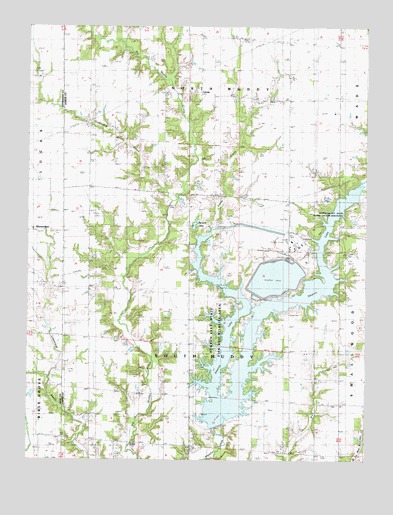
Latona, IL USGS Topographic Map
Click on map above to begin viewing in our Map Viewer.

This topographic map contains these locations and features:
Feature Name Type Latitude Longitude GNIS ID View Map
Abbott CemeteryCemeteryN38.8869°W88.3235°1923071View Map
Bailey CemeteryCemeteryN38.9920°W88.3403°403802View Map
Boone Post Office (historical)Post OfficeN38.9495°W88.2875°1815644View Map
Burgett LakeReservoirN38.9431°W88.3133°405220View Map
Burgett Lake DamDamN38.9434°W88.3139°1691782View Map
Crabapple CreekStreamN38.9495°W88.3228°406706View Map
Devore CemeteryCemeteryN38.8778°W88.2825°1923103View Map
Foster CemeteryCemeteryN38.9475°W88.2739°1923107View Map
Freeman CemeteryCemeteryN38.9386°W88.3459°1923110View Map
Fulks CemeteryCemeteryN38.8869°W88.3235°408791View Map
Galloway School (historical)SchoolN38.8962°W88.3528°408858View Map
Headyville CemeteryCemeteryN38.9100°W88.3423°1923117View Map
Headyville ChurchChurchN38.9103°W88.3439°410000View Map
Jasper County State Prairie Chicken SanctuaryParkN38.9464°W88.2539°1725220View Map
Johnson FarmsLocaleN38.9883°W88.3156°2724529View Map
Kedron CemeteryCemeteryN38.9795°W88.2839°1923126View Map
Kedron School (historical)SchoolN38.9812°W88.2787°411337View Map
Kedron United Methodist ChurchChurchN38.9803°W88.2784°2055247View Map
Lancaster CemeteryCemeteryN38.8917°W88.2581°1923128View Map
LatonaPopulated PlaceN38.9806°W88.3117°422899View Map
Latona Church of ChristChurchN38.9812°W88.3120°2055243View Map
Laws CreekStreamN38.8892°W88.3048°411875View Map
Long BranchStreamN38.9539°W88.2534°412553View Map
Newton LakeReservoirN38.9146°W88.2894°1725223View Map
Newton Lake State Fish and Wildlife AreaParkN38.9128°W88.3056°1725224View Map
Newton Power PlantBuildingN38.9373°W88.2763°2419851View Map
Newton Power Station LakeReservoirN38.8850°W88.3034°1691785View Map
Newton Power Station Lake DamDamN38.8850°W88.3034°1691784View Map
Pleasant Valley CemeteryCemeteryN38.8778°W88.2828°415898View Map
Sandy CreekStreamN38.8892°W88.3045°417993View Map
South Muddy CemeteryCemeteryN38.8870°W88.3242°1923582View Map
South Muddy ChurchChurchN38.8870°W88.3242°418802View Map
Tate CemeteryCemeteryN38.9239°W88.2595°419546View Map
Texler CemeteryCemeteryN38.9803°W88.2845°419618View Map
Township of South MuddyCivilN38.9003°W88.3104°429773View Map
Union School (historical)SchoolN38.9514°W88.3156°420093View Map
Worthey CemeteryCemeteryN38.9406°W88.3061°421513View Map
Worthy CemeteryCemeteryN38.9400°W88.3050°1923604View Map

Note: Coordinates in the location and feature list above are referenced to NAD83 datum.


Copyright (C) 2008-2024 Ryan Niemi / Sunset Dynamics ... All Rights Reserved