TopoQuest Logo
Do you find TopoQuest useful?
Help keep TopoQuest running and adding new maps/features by donating!
Bitcoin:  19c7KJd3qBynnjoSw5npx9KScwjBe4ifkT
Litecoin:  LXs6TkuXGGXo1vDsWCkWVdjQX94eUKd6ui
Home View Maps Find Maps Find Places Resources & Links


Largent, West Virginia Topographic Map

USGS Map Title: Largent, WV
USGS Map MRC: 39078D4
DRG (GeoTIFF) Download: o39078d4.tif


Neighboring USGS Topographic Map Quads:


  Oldtown, MD  
39078E5
 

  Paw Paw, WV  
39078E4
 

  Great Cacapon, WV  
39078E3
 

  Levels, WV  
39078D5
 

  Largent, WV  
39078D4
 

  Ridge, WV  
39078D3
 

  Hanging Rock, WV  
39078C5
 

  Capon Bridge, WV  
39078C4
 

  Gore, VA  
39078C3


Map MRC Location:

N40°
W79°
N40°
W78°
H8 H7 H6 H5 H4 H3 H2 H1
G8 G7 G6 G5 G4 G3 G2 G1
F8 F7 F6 F5 F4 F3 F2 F1
E8 E7 E6 E5 E4 E3 E2 E1
D8 D7 D6 D5 D4 D3 D2 D1
C8 C7 C6 C5 C4 C3 C2 C1
B8 B7 B6 B5 B4 B3 B2 B1
A8 A7 A6 A5 A4 A3 A2 A1
N39°
W79°
N39°
W78°

Largent, WV USGS 1:24K Topographic Map Preview:
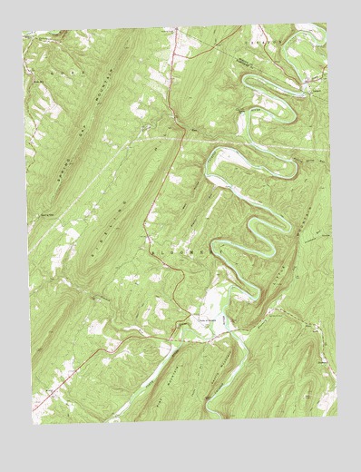
Largent, WV USGS Topographic Map
Click on map above to begin viewing in our Map Viewer.

This topographic map contains these locations and features:
Feature Name Type Latitude Longitude GNIS ID View Map
Bethel ChurchChurchN39.4981°W78.4964°1535714View Map
Bloomery DistrictCivilN39.3856°W78.4319°1928169View Map
Bloomery RunStreamN39.4023°W78.4170°1536111View Map
Bowers RunStreamN39.4518°W78.4203°1536260View Map
CacapehonPopulated PlaceN39.4984°W78.4953°1718607View Map
Castle MountainSummitN39.3937°W78.4186°1554086View Map
Castle RockPillarN39.3818°W78.4289°1537092View Map
Castle RunStreamN39.4004°W78.4281°1537093View Map
Critton RunStreamN39.4657°W78.4081°1537827View Map
Critton School (historical)SchoolN39.4579°W78.4589°1556755View Map
Crooked RunStreamN39.3998°W78.4381°1537851View Map
Diamond RidgeRidgeN39.3832°W78.3870°1718624View Map
Enon CemeteryCemeteryN39.4820°W78.3772°1558021View Map
Enon School (historical)SchoolN39.4851°W78.3767°1557929View Map
Eubulus ChurchChurchN39.4732°W78.4114°1538747View Map
Falling Spring RunStreamN39.4568°W78.3922°1538865View Map
Forks of CacaponLocaleN39.4068°W78.4308°1539146View Map
Furnace School (historical)SchoolN39.4098°W78.3989°1556765View Map
Horsebone HollowValleyN39.4309°W78.3872°1540500View Map
Island Hill CemeteryCemeteryN39.4049°W78.4397°2726622View Map
Island Hill ChurchChurchN39.4051°W78.4392°1540739View Map
Ivy RunStreamN39.4101°W78.4011°1540757View Map
Johnson HollowValleyN39.4981°W78.4938°1540986View Map
LargentPopulated PlaceN39.4779°W78.3822°1541353View Map
Linnie Hiett SpringSpringN39.3987°W78.4300°1677918View Map
Mount Union ChurchChurchN39.3843°W78.4914°1543781View Map
Mount Union Church CemeteryCemeteryN39.3843°W78.4917°2726658View Map
Mount Union School (historical)SchoolN39.3901°W78.4797°1556784View Map
Neals RunPopulated PlaceN39.4834°W78.4964°1555193View Map
North RiverStreamN39.4093°W78.4208°1552345View Map
Old Bethel Church CemeteryCemeteryN39.4979°W78.4966°2726660View Map
Old Enon CemeteryCemeteryN39.4976°W78.3822°1558029View Map
Pinoak School (historical)SchoolN39.4379°W78.4514°1556790View Map
Spring GapGapN39.4409°W78.4950°1547193View Map
Spring Gap MountainSummitN39.4576°W78.4815°1547195View Map
Stony CreekStreamN39.4815°W78.3842°1547493View Map
Victory School (historical)SchoolN39.4648°W78.4136°1556809View Map
Wolf HollowValleyN39.4529°W78.4267°1549279View Map
WoodrowPopulated PlaceN39.4993°W78.4364°1557990View Map
Woodrow Church CemeteryCemeteryN39.4998°W78.4383°1718733View Map
Woodrow School (historical)SchoolN39.4940°W78.4364°1556820View Map
Woodrow Union ChurchChurchN39.4993°W78.4364°1549380View Map

Note: Coordinates in the location and feature list above are referenced to NAD83 datum.


Copyright (C) 2008-2024 Ryan Niemi / Sunset Dynamics ... All Rights Reserved