TopoQuest Logo
Do you find TopoQuest useful?
Help keep TopoQuest running and adding new maps/features by donating!
Bitcoin:  19c7KJd3qBynnjoSw5npx9KScwjBe4ifkT
Litecoin:  LXs6TkuXGGXo1vDsWCkWVdjQX94eUKd6ui
Home View Maps Find Maps Find Places Resources & Links


Laneville, West Virginia Topographic Map

USGS Map Title: Laneville, WV
USGS Map MRC: 38079H4
DRG (GeoTIFF) Download: o38079h4.tif


Neighboring USGS Topographic Map Quads:


  Mozark Mountain, WV  
39079A5
 

  Blackwater Falls, WV  
39079A4
 

  Blackbird Knob, WV  
39079A3
 

  Harman, WV  
38079H5
 

  Laneville, WV  
38079H4
 

  Hopeville, WV  
38079H3
 

  Whitmer, WV  
38079G5
 

  Onego, WV  
38079G4
 

  Upper Tract, WV  
38079G3


Map MRC Location:

N39°
W80°
N39°
W79°
H8 H7 H6 H5 H4 H3 H2 H1
G8 G7 G6 G5 G4 G3 G2 G1
F8 F7 F6 F5 F4 F3 F2 F1
E8 E7 E6 E5 E4 E3 E2 E1
D8 D7 D6 D5 D4 D3 D2 D1
C8 C7 C6 C5 C4 C3 C2 C1
B8 B7 B6 B5 B4 B3 B2 B1
A8 A7 A6 A5 A4 A3 A2 A1
N38°
W80°
N38°
W79°

Laneville, WV USGS 1:24K Topographic Map Preview:
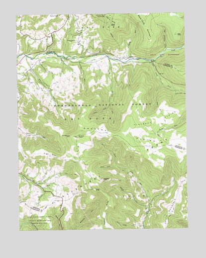
Laneville, WV USGS Topographic Map
Click on map above to begin viewing in our Map Viewer.

This topographic map contains these locations and features:
Feature Name Type Latitude Longitude GNIS ID View Map
Addie Judy SpringSpringN38.9734°W79.4170°1677839View Map
Arbogast Farm SpringSpringN38.8862°W79.4053°1677740View Map
Bethel ChurchChurchN38.9834°W79.4539°1550272View Map
Big RunStreamN38.9759°W79.4926°1550326View Map
Boars Nest TrailTrailN38.9462°W79.3959°1550408View Map
Bonner Mountain School (historical)SchoolN38.9559°W79.4764°1677691View Map
Canaan CrossingPopulated PlaceN38.9748°W79.4637°1554059View Map
Coal KnobSummitN38.9876°W79.3806°1550738View Map
Collins RunStreamN38.9751°W79.4576°1550773View Map
Days Mill (historical)LocaleN38.9043°W79.4926°1727058View Map
Dolly RunStreamN38.8793°W79.4970°1550939View Map
Dryfork Post OfficePost OfficeN38.9721°W79.4976°1727060View Map
Elklick RunStreamN38.8862°W79.4034°1551040View Map
Flanagan Memorial CemeteryCemeteryN38.9859°W79.4589°1551128View Map
Flat Top School (historical)SchoolN38.9779°W79.4964°1677833View Map
Flatrock PlainsFlatN38.9373°W79.3959°1551138View Map
Flatrock RunStreamN38.9746°W79.4314°1551139View Map
Gandy RunStreamN38.9734°W79.4150°1551202View Map
Green KnobSummitN38.8987°W79.4448°1554601View Map
Guy Harper SpringSpringN38.8940°W79.4726°1677688View Map
HarpertonPopulated PlaceN38.9021°W79.4867°1677689View Map
Hartman Farm SpringSpringN38.8946°W79.4039°1677739View Map
Haystack KnobSummitN38.9046°W79.4381°1551399View Map
High MountainSummitN38.9184°W79.4753°1551433View Map
Hoffman RidgeRidgeN38.8862°W79.4359°1551462View Map
Hoyt Pennington SpringSpringN38.9751°W79.4331°1677685View Map
Hoyt Pennington SpringSpringN38.9721°W79.3995°1677686View Map
LanevillePopulated PlaceN38.9740°W79.4173°1554910View Map
Laneville Mennonite ChurchChurchN38.9746°W79.4200°1689373View Map
Lee Ullery SpringSpringN38.9748°W79.4273°1677838View Map
Left Fork Flatrock CreekStreamN38.9468°W79.4317°1551771View Map
Little Stonecoal RunStreamN38.9790°W79.3884°1551896View Map
Long RunStreamN38.8904°W79.4020°1551927View Map
Mount Porte CrayonSummitN38.9290°W79.4562°1552541View Map
Mount Porte Crayon Point of InterestLocaleN38.9287°W79.4559°1553666View Map
Nelson SpringSpringN38.9751°W79.4314°1677837View Map
North Fork Long RunStreamN38.9121°W79.4275°1552334View Map
Pennington Farm SpringSpringN38.9723°W79.4220°1677687View Map
Right Fork Flatrock CreekStreamN38.9468°W79.4317°1552660View Map
Roaring PlainsBasinN38.9287°W79.4242°1552688View Map
Roaring Plains West WildernessReserveN38.9268°W79.4253°2767379View Map
Roaring School (historical)SchoolN38.8818°W79.4059°1677612View Map
Smith MountainSummitN38.8851°W79.3873°1555647View Map
Snoden Yokum SpringSpringN38.9079°W79.4906°1677692View Map
Snoden Yokum SpringSpringN38.9104°W79.4987°1677693View Map
South Fork Long RunStreamN38.9121°W79.4275°1552975View Map
South Fork Red CreekStreamN38.9723°W79.4009°1552979View Map
Stone Camp MountainRidgeN38.9923°W79.4034°1553065View Map
Stone Camp RunStreamN38.8762°W79.4075°1553066View Map
Stringtown (historical)Populated PlaceN38.9890°W79.4737°1689416View Map
Thunderstruck RockPillarN38.9293°W79.4612°1553234View Map
Weiss KnobSummitN38.9937°W79.4298°1555935View Map
Wolford ChurchChurchN38.9873°W79.4748°1553505View Map
Wolford School (historical)SchoolN38.9896°W79.4676°1677834View Map
Wyatt Farm SpringSpringN38.9946°W79.4539°1677836View Map
Wyoming (historical)Populated PlaceN38.9737°W79.4275°1727044View Map

Note: Coordinates in the location and feature list above are referenced to NAD83 datum.


Copyright (C) 2008-2024 Ryan Niemi / Sunset Dynamics ... All Rights Reserved