TopoQuest Logo
Do you find TopoQuest useful?
Help keep TopoQuest running and adding new maps/features by donating!
Bitcoin:  19c7KJd3qBynnjoSw5npx9KScwjBe4ifkT
Litecoin:  LXs6TkuXGGXo1vDsWCkWVdjQX94eUKd6ui
Home View Maps Find Maps Find Places Resources & Links


Lanely, Texas Topographic Map

USGS Map Title: Lanely, TX
USGS Map MRC: 31096E1
DRG (GeoTIFF) Download: o31096e1.tif


Neighboring USGS Topographic Map Quads:


  Fairfield, TX  
31096F2
 

  Turlington, TX  
31096F1
 

  Butler, TX  
31095F8
 

  Dew, TX  
31096E2
 

  Lanely, TX  
31096E1
 

  Keechi, TX  
31095E8
 

  Donie, TX  
31096D2
 

  Buffalo, TX  
31096D1
 

  Flo, TX  
31095D8


Map MRC Location:

N32°
W97°
N32°
W96°
H8 H7 H6 H5 H4 H3 H2 H1
G8 G7 G6 G5 G4 G3 G2 G1
F8 F7 F6 F5 F4 F3 F2 F1
E8 E7 E6 E5 E4 E3 E2 E1
D8 D7 D6 D5 D4 D3 D2 D1
C8 C7 C6 C5 C4 C3 C2 C1
B8 B7 B6 B5 B4 B3 B2 B1
A8 A7 A6 A5 A4 A3 A2 A1
N31°
W97°
N31°
W96°

Lanely, TX USGS 1:24K Topographic Map Preview:
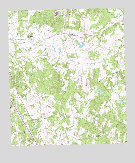
Lanely, TX USGS Topographic Map
Click on map above to begin viewing in our Map Viewer.

This topographic map contains these locations and features:
Feature Name Type Latitude Longitude GNIS ID View Map
Burleson HillSummitN31.6004°W96.1027°1372838View Map
Chandler BottomBendN31.5438°W96.0927°1373050View Map
ConcordPopulated PlaceN31.5249°W96.0569°1380830View Map
Dottie BranchStreamN31.5052°W96.0522°1373432View Map
Folsom HillsSummitN31.6118°W96.0761°1373746View Map
Fulks DugoutStreamN31.5046°W96.1077°1373785View Map
Harrison Chapel CemeteryCemeteryN31.5652°W96.1000°1374012View Map
Holly Grove CemeteryCemeteryN31.5116°W96.1161°1374111View Map
LanelyPopulated PlaceN31.6007°W96.0600°1380871View Map
Little Star ChurchChurchN31.5155°W96.0850°1374612View Map
Marshy SpringsPopulated PlaceN31.5238°W96.1014°1380882View Map
Mount Pleasant ChurchChurchN31.5652°W96.0069°1375032View Map
Plum CreekStreamN31.6166°W96.0050°1375503View Map
Plum Creek Ranch DamDamN31.5935°W96.0452°1855579View Map
Plum Creek Ranch LakeReservoirN31.5913°W96.0462°1855580View Map
Self CreekStreamN31.5368°W96.0730°1376061View Map
Snider Lake DamDamN31.5485°W96.0302°1855581View Map
Snyder LakeReservoirN31.5482°W96.0279°1855582View Map
Texas No Name Number 12 DamDamN31.6218°W96.0702°1864199View Map

Note: Coordinates in the location and feature list above are referenced to NAD83 datum.


Copyright (C) 2008-2024 Ryan Niemi / Sunset Dynamics ... All Rights Reserved