TopoQuest Logo
Do you find TopoQuest useful?
Help keep TopoQuest running and adding new maps/features by donating!
Bitcoin:  19c7KJd3qBynnjoSw5npx9KScwjBe4ifkT
Litecoin:  LXs6TkuXGGXo1vDsWCkWVdjQX94eUKd6ui
Home View Maps Find Maps Find Places Resources & Links


Lake Como, Texas Topographic Map

USGS Map Title: Lake Como, TX
USGS Map MRC: 29094B8
DRG (GeoTIFF) Download: o29094b8.tif


Neighboring USGS Topographic Map Quads:


  Hitchcock, TX  
29095C1
 

  Virginia Point, TX  
29094C8
 

  Galveston, TX  
29094C7
 

  Sea Isle, TX  
29095B1
 

  Lake Como, TX  
29094B8


  San Luis Pass, TX  
29095A1


Map MRC Location:

N30°
W95°
N30°
W94°
H8 H7 H6 H5 H4 H3 H2 H1
G8 G7 G6 G5 G4 G3 G2 G1
F8 F7 F6 F5 F4 F3 F2 F1
E8 E7 E6 E5 E4 E3 E2 E1
D8 D7 D6 D5 D4 D3 D2 D1
C8 C7 C6 C5 C4 C3 C2 C1
B8 B7 B6 B5 B4 B3 B2 B1
A8 A7 A6 A5 A4 A3 A2 A1
N29°
W95°
N29°
W94°

Lake Como, TX USGS 1:24K Topographic Map Preview:
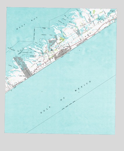
Lake Como, TX USGS Topographic Map
Click on map above to begin viewing in our Map Viewer.

This topographic map contains these locations and features:
Feature Name Type Latitude Longitude GNIS ID View Map
Bermuda BeachBeachN29.2094°W94.9241°1381104View Map
Bermuda BeachBeachN29.2161°W94.9146°1384967View Map
Butterowe BayouGutN29.2086°W94.9710°1353435View Map
Carancahua CoveBayN29.2055°W94.9777°1353810View Map
Carancahua ReefBarN29.2105°W94.9974°1353814View Map
City of Jamaica BeachCivilN29.1913°W94.9807°2410132View Map
Dalehite CoveBayN29.2238°W94.9524°1377695View Map
Dana CoveBayN29.2127°W94.9624°1355619View Map
Eckert BayouGutN29.2238°W94.9369°1381029View Map
Galveston County Health District - Galveston County Emergency Medical Service Station 4BuildingN29.1821°W94.9754°2720837View Map
Galveston DivisionCivilN29.2341°W94.8897°1938766View Map
Galveston Fire Department Station 7BuildingN29.2102°W94.9389°2334410View Map
Galveston IslandIslandN29.2222°W94.9088°1357843View Map
Galveston Island State ParkParkN29.2050°W94.9663°1385025View Map
Galveston Island State Park TrailTrailN29.1958°W94.9558°2032760View Map
Ganas BayouGutN29.2497°W94.9085°1381113View Map
Gangs BayouGutN29.2461°W94.9052°1377696View Map
Gangs BayouGutN29.2497°W94.9085°1380962View Map
Hoeckers PointCapeN29.2288°W94.9563°1359334View Map
Jamaica BeachBeachN29.1947°W94.9774°1381101View Map
Jamaica BeachPopulated PlaceN29.1897°W94.9796°1388565View Map
Jamaica Beach City HallBuildingN29.1823°W94.9748°2753423View Map
Jamaica Beach Police DepartmentBuildingN29.1818°W94.9748°2375921View Map
Jamaica Beach Volunteer Fire DepartmentBuildingN29.1822°W94.9748°2334595View Map
Jumbile CoveGutN29.1911°W94.9924°1360465View Map
Lafitte GroveWoodsN29.2119°W94.9358°1385056View Map
Lake ComoLakeN29.2128°W94.9502°1354847View Map
Mary Moody Northern AmphitheaterBasinN29.2050°W94.9560°1385073View Map
Mary Star of the Sea ChurchChurchN29.1827°W94.9744°1385074View Map
Melager CoveGutN29.2411°W94.9321°1362582View Map
Mentzel BayouGutN29.2369°W94.9283°1381030View Map
NottinghamAreaN29.2111°W94.9285°1385094View Map
Oak BayouGutN29.2083°W94.9616°1364260View Map
Oxen BayouGutN29.2466°W94.9177°1381031View Map
Palm BeachBeachN29.2011°W94.9433°1381102View Map
Pirates BeachBeachN29.2033°W94.9338°1381103View Map
Pirates Beach MarinaLocaleN29.2083°W94.9485°2030477View Map
Pirates CoveBayN29.2158°W94.9471°1381105View Map
Sand Castle Beach Pocket Park 2ParkN29.2277°W94.8949°1384964View Map
Sea Gull Shores Beach Pocket Park 1ParkN29.2377°W94.8788°1384963View Map
Sea Shell Beach Pocket Park 3ParkN29.2019°W94.9263°1384965View Map
Spanish Grant NorthCivilN29.2258°W94.9188°1385138View Map
Spanish Grant SouthCivilN29.2189°W94.9096°1385139View Map
Starvation CoveGutN29.2355°W94.9366°1369132View Map
The RidgeRidgeN29.2150°W94.9405°1385108View Map
West BeachBeachN29.2177°W94.9094°1371064View Map
West Isle ChurchChurchN29.2119°W94.9388°1385167View Map
West Isle Presbyterian ChurchChurchN29.2122°W94.9391°2018664View Map

Note: Coordinates in the location and feature list above are referenced to NAD83 datum.


Copyright (C) 2008-2024 Ryan Niemi / Sunset Dynamics ... All Rights Reserved