TopoQuest Logo
Do you find TopoQuest useful?
Help keep TopoQuest running and adding new maps/features by donating!
Bitcoin:  19c7KJd3qBynnjoSw5npx9KScwjBe4ifkT
Litecoin:  LXs6TkuXGGXo1vDsWCkWVdjQX94eUKd6ui
Home View Maps Find Maps Find Places Resources & Links


Lake Bowdoin, Montana Topographic Map

USGS Map Title: Lake Bowdoin, MT
USGS Map MRC: 48107D6
DRG (GeoTIFF) Download: o48107d6.tif


Neighboring USGS Topographic Map Quads:


  Fanny Hill, MT  
48107E7
 

  Hewitt Lake SW, MT  
48107E6
 

  Hewitt Lake, MT  
48107E5
 

  Malta NE, MT  
48107D7
 

  Lake Bowdoin, MT  
48107D6
 

  Bowdoin, MT  
48107D5
 

  Malta East, MT  
48107C7
 

  Clanton Coulee, MT  
48107C6
 

  Pinks, MT  
48107C5


Map MRC Location:

N49°
W108°
N49°
W107°
H8 H7 H6 H5 H4 H3 H2 H1
G8 G7 G6 G5 G4 G3 G2 G1
F8 F7 F6 F5 F4 F3 F2 F1
E8 E7 E6 E5 E4 E3 E2 E1
D8 D7 D6 D5 D4 D3 D2 D1
C8 C7 C6 C5 C4 C3 C2 C1
B8 B7 B6 B5 B4 B3 B2 B1
A8 A7 A6 A5 A4 A3 A2 A1
N48°
W108°
N48°
W107°

Lake Bowdoin, MT USGS 1:24K Topographic Map Preview:
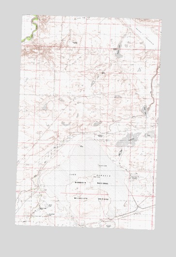
Lake Bowdoin, MT USGS Topographic Map
Click on map above to begin viewing in our Map Viewer.

This topographic map contains these locations and features:
Feature Name Type Latitude Longitude GNIS ID View Map
31N31E22DAC_10 WellWellN48.4286°W107.6737°1635514View Map
Bebee SpringSpringN48.4669°W107.6782°800194View Map
Black CouleeValleyN48.3778°W107.7393°768952View Map
Black Coulee PondReservoirN48.3850°W107.7302°800185View Map
Bowdoin National Wildlife RefugeParkN48.4022°W107.6631°806841View Map
Dry Lake CanalCanalN48.4097°W107.6529°800189View Map
Erphit LakeLakeN48.4800°W107.6629°806294View Map
Erphit SpringSpringN48.4808°W107.6645°806293View Map
Erphit SpringSpringN48.4817°W107.6648°800193View Map
Farm PondReservoirN48.4200°W107.6586°800182View Map
Lake BowdoinLakeN48.4043°W107.6851°769135View Map
Lakeside SpringSpringN48.4297°W107.6754°800191View Map
Lakeside UnitLakeN48.4285°W107.6468°800181View Map
Lakeside_SpringSpringN48.4297°W107.6748°1635520View Map
Lone Tree Lake (historical)LakeN48.4906°W107.6373°806276View Map
Long IslandIslandN48.4231°W107.6962°800188View Map
Mud LakeLakeN48.4454°W107.6380°800192View Map
North Strater School (historical)SchoolN48.4522°W107.7154°1721922View Map
Patrol Road PondReservoirN48.3815°W107.7224°800183View Map
Pelican IslandsIslandN48.4117°W107.6773°800187View Map
Starter PondReservoirN48.3871°W107.7229°800184View Map
Strater School (historical)SchoolN48.3800°W107.7498°1721941View Map
Teal Pond ComplexSwampN48.4070°W107.6480°800190View Map
Townsend SpringSpringN48.4842°W107.7004°800195View Map
Woody IslandIslandN48.4050°W107.6826°800186View Map

Note: Coordinates in the location and feature list above are referenced to NAD83 datum.


Copyright (C) 2008-2024 Ryan Niemi / Sunset Dynamics ... All Rights Reserved