TopoQuest Logo
Do you find TopoQuest useful?
Help keep TopoQuest running and adding new maps/features by donating!
Bitcoin:  19c7KJd3qBynnjoSw5npx9KScwjBe4ifkT
Litecoin:  LXs6TkuXGGXo1vDsWCkWVdjQX94eUKd6ui
Home View Maps Find Maps Find Places Resources & Links


Lake Berryessa, California Topographic Map

USGS Map Title: Lake Berryessa, CA
USGS Map MRC: 38122E2
DRG (GeoTIFF) Download: o38122e2.tif


Neighboring USGS Topographic Map Quads:


  Walter Springs, CA  
38122F3
 

  Brooks, CA  
38122F2
 

  Esparto, CA  
38122F1
 

  Chiles Valley, CA  
38122E3
 

  Lake Berryessa, CA  
38122E2
 

  Monticello Dam, CA  
38122E1
 

  Yountville, CA  
38122D3
 

  Capell Valley, CA  
38122D2
 

  Mount Vaca, CA  
38122D1


Map MRC Location:

N39°
W123°
N39°
W122°
H8 H7 H6 H5 H4 H3 H2 H1
G8 G7 G6 G5 G4 G3 G2 G1
F8 F7 F6 F5 F4 F3 F2 F1
E8 E7 E6 E5 E4 E3 E2 E1
D8 D7 D6 D5 D4 D3 D2 D1
C8 C7 C6 C5 C4 C3 C2 C1
B8 B7 B6 B5 B4 B3 B2 B1
A8 A7 A6 A5 A4 A3 A2 A1
N38°
W123°
N38°
W122°

Lake Berryessa, CA USGS 1:24K Topographic Map Preview:
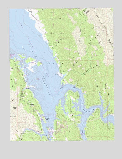
Lake Berryessa, CA USGS Topographic Map
Click on map above to begin viewing in our Map Viewer.

This topographic map contains these locations and features:
Feature Name Type Latitude Longitude GNIS ID View Map
Alfalfa Patch ReservoirReservoirN38.6250°W122.1764°218115View Map
Apple Tree CanyonValleyN38.5674°W122.1533°218318View Map
Berryessa HighlandsPopulated PlaceN38.5146°W122.1878°1657269View Map
Berryessa MarinaLocaleN38.5799°W122.2489°219085View Map
Big IslandIslandN38.5735°W122.2236°1657264View Map
Brushy CanyonValleyN38.5844°W122.1591°219941View Map
Camp North (historical)LocaleN38.5507°W122.1769°1670447View Map
Capell Cove Boat RampLocaleN38.5077°W122.2180°1657275View Map
Dardon CanyonValleyN38.5666°W122.1753°222013View Map
Dufer PointCapeN38.5514°W122.2265°2711979View Map
Goat IslandIslandN38.5591°W122.2186°1657263View Map
Gosling CanyonValleyN38.5585°W122.1897°224353View Map
Gunn RanchLocaleN38.5619°W122.1914°224742View Map
Jackson CreekStreamN38.6105°W122.2144°226080View Map
Jackson PeakSummitN38.6207°W122.1972°226089View Map
Lake BerryessaReservoirN38.5868°W122.2275°255067View Map
Lake Berryessa Park HeadquartersLocaleN38.5507°W122.2316°226794View Map
Lake Berryessa Recreation AreaParkN38.5763°W122.2178°1657227View Map
Las PutasCivilN38.5999°W122.2344°234139View Map
Lion CanyonValleyN38.5905°W122.1536°227170View Map
Little Portuguese CanyonValleyN38.5330°W122.1414°227332View Map
Meeks Ranch (historical)LocaleN38.5444°W122.2119°1670450View Map
Monticello (historical)Populated PlaceN38.5777°W122.2072°1670451View Map
Monticello CemeteryCemeteryN38.5368°W122.2275°228983View Map
Napa County Fire Department Station 24 Spanish FlatBuildingN38.5380°W122.2330°2624037View Map
Oak Shores ParkLocaleN38.5621°W122.2339°1657268View Map
Oil Well CanyonValleyN38.5866°W122.2011°229950View Map
Oil Well CanyonValleyN38.5952°W122.1519°229951View Map
Portuguese CanyonValleyN38.5257°W122.1403°230966View Map
Quarry CanyonValleyN38.5482°W122.2219°231120View Map
Redbud Park (historical)Populated PlaceN38.5194°W122.1372°1670453View Map
Right-Hand CanyonValleyN38.5766°W122.1544°231583View Map
Rocky RidgeRidgeN38.5832°W122.1261°255724View Map
Sidwell Ranch (historical)LocaleN38.5263°W122.1597°1670454View Map
Small IslandIslandN38.5796°W122.2372°1657265View Map
Smittle Creek Picnic AreaLocaleN38.5769°W122.2450°1657266View Map
South Shore ResortLocaleN38.5002°W122.1636°1657267View Map
Spanish FlatPopulated PlaceN38.5352°W122.2250°235153View Map
Spanish Flat ResortPopulated PlaceN38.5199°W122.2097°1659833View Map
Steel CanyonValleyN38.5055°W122.2069°235423View Map
Steel Canyon ResortPopulated PlaceN38.5080°W122.2033°1659862View Map
Sugarloaf Hunting Club (historical)LocaleN38.5413°W122.2375°1670455View Map
Sugarloaf ParkLocaleN38.5419°W122.2378°235672View Map
Sugarloaf PeakSummitN38.5307°W122.2461°235675View Map
Tibipa Ranch (historical)LocaleN38.5102°W122.2344°1670456View Map
Tin Can CanyonValleyN38.5994°W122.2089°236373View Map
Tully CanyonValleyN38.6207°W122.2178°255163View Map
Wallet CanyonValleyN38.6052°W122.1528°237195View Map
Weiss Ranch (historical)LocaleN38.5413°W122.2008°1670457View Map
Wragg CanyonValleyN38.5216°W122.1619°238191View Map

Note: Coordinates in the location and feature list above are referenced to NAD83 datum.


Copyright (C) 2008-2024 Ryan Niemi / Sunset Dynamics ... All Rights Reserved