TopoQuest Logo
Do you find TopoQuest useful?
Help keep TopoQuest running and adding new maps/features by donating!
Bitcoin:  19c7KJd3qBynnjoSw5npx9KScwjBe4ifkT
Litecoin:  LXs6TkuXGGXo1vDsWCkWVdjQX94eUKd6ui
Home View Maps Find Maps Find Places Resources & Links


Labyrinth Mountain, Washington Topographic Map

USGS Map Title: Labyrinth Mountain, WA
USGS Map MRC: 47121G1
DRG (GeoTIFF) Download: o47121g1.tif


Neighboring USGS Topographic Map Quads:


  Benchmark Mountain, WA  
47121H2
 

  Poe Mountain, WA  
47121H1
 

  Mount David, WA  
47120H8
 

  Captain Point, WA  
47121G2
 

  Labyrinth Mountain, WA  
47121G1
 

  Mount Howard, WA  
47120G8
 

  Scenic, WA  
47121F2
 

  Stevens Pass, WA  
47121F1
 

  Chiwaukum Mountains, WA  
47120F8


Map MRC Location:

N48°
W122°
N48°
W121°
H8 H7 H6 H5 H4 H3 H2 H1
G8 G7 G6 G5 G4 G3 G2 G1
F8 F7 F6 F5 F4 F3 F2 F1
E8 E7 E6 E5 E4 E3 E2 E1
D8 D7 D6 D5 D4 D3 D2 D1
C8 C7 C6 C5 C4 C3 C2 C1
B8 B7 B6 B5 B4 B3 B2 B1
A8 A7 A6 A5 A4 A3 A2 A1
N47°
W122°
N47°
W121°

Labyrinth Mountain, WA USGS 1:24K Topographic Map Preview:
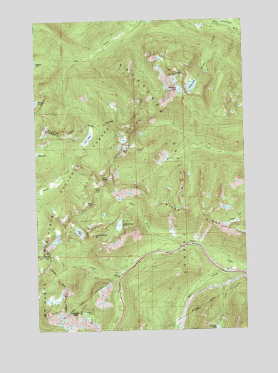
Labyrinth Mountain, WA USGS Topographic Map
Click on map above to begin viewing in our Map Viewer.

This topographic map contains these locations and features:
Feature Name Type Latitude Longitude GNIS ID View Map
Devils Club CreekStreamN47.8696°W121.0004°1518701View Map
Dow LakeLakeN47.8011°W121.0965°1518905View Map
Elevenmile CreekStreamN47.8734°W121.0123°1519255View Map
Jove LakeLakeN47.8246°W121.0675°1521479View Map
Jove PeakSummitN47.8223°W121.0734°1521480View Map
Labyrinth MountainSummitN47.8526°W121.0426°1521807View Map
Lake JanusLakeN47.8272°W121.0949°1521328View Map
Lake ValhallaLakeN47.7898°W121.1008°1527658View Map
Lanham CreekStreamN47.7734°W121.0134°1521894View Map
Lanham LakeLakeN47.7504°W121.0186°1521895View Map
Lichtenberg MountainSummitN47.7879°W121.0909°1522062View Map
Lichtenwasser LakeLakeN47.7924°W121.0768°1522063View Map
Lodgepole CreekStreamN47.8729°W121.0090°1522350View Map
Mill CreekStreamN47.7765°W121.0112°1523159View Map
Minotaur LakeLakeN47.8466°W121.0389°1523254View Map
Mount McCauslandSummitN47.7968°W121.1034°1528578View Map
Old Cascade TunnelTunnelN47.7621°W121.0984°1529739View Map
Skyline LakeLakeN47.7568°W121.0979°1525901View Map
Smith BrookStreamN47.7821°W121.0532°1525965View Map
Stevens CreekStreamN47.7729°W121.0773°1526549View Map
Theseus CreekStreamN47.8732°W121.0176°1527081View Map
Theseus Creek CampgroundLocaleN47.8726°W121.0179°1529741View Map
Theseus LakeLakeN47.8485°W121.0314°1527082View Map
Totem Girl Scout Org CampLocaleN47.7809°W121.0540°1529740View Map
Tye LakeLakeN47.7651°W121.1121°1527048View Map
Union GapGapN47.8071°W121.0859°1527612View Map
Union PeakSummitN47.8112°W121.0826°1527613View Map

Note: Coordinates in the location and feature list above are referenced to NAD83 datum.


Copyright (C) 2008-2024 Ryan Niemi / Sunset Dynamics ... All Rights Reserved