TopoQuest Logo
Do you find TopoQuest useful?
Help keep TopoQuest running and adding new maps/features by donating!
Bitcoin:  19c7KJd3qBynnjoSw5npx9KScwjBe4ifkT
Litecoin:  LXs6TkuXGGXo1vDsWCkWVdjQX94eUKd6ui
Home View Maps Find Maps Find Places Resources & Links


Klondyke, Arizona Topographic Map

USGS Map Title: Klondyke, AZ
USGS Map MRC: 32110G3
DRG (GeoTIFF) Download: o32110g3.tif


Neighboring USGS Topographic Map Quads:


  Booger Canyon, AZ  
32110H4
 

  Cobre Grande Mountain, AZ  
32110H3
 

  Jackson Mountain, AZ  
32110H2
 

  Oak Grove Canyon, AZ  
32110G4
 

  Klondyke, AZ  
32110G3
 

  Buford Hill, AZ  
32110G2
 

  Rhodes Peak, AZ  
32110F4
 

  Kennedy Peak, AZ  
32110F3
 

  Eureka Ranch, AZ  
32110F2


Map MRC Location:

N33°
W111°
N33°
W110°
H8 H7 H6 H5 H4 H3 H2 H1
G8 G7 G6 G5 G4 G3 G2 G1
F8 F7 F6 F5 F4 F3 F2 F1
E8 E7 E6 E5 E4 E3 E2 E1
D8 D7 D6 D5 D4 D3 D2 D1
C8 C7 C6 C5 C4 C3 C2 C1
B8 B7 B6 B5 B4 B3 B2 B1
A8 A7 A6 A5 A4 A3 A2 A1
N32°
W111°
N32°
W110°

Klondyke, AZ USGS 1:24K Topographic Map Preview:
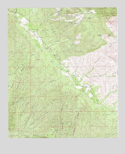
Klondyke, AZ USGS Topographic Map
Click on map above to begin viewing in our Map Viewer.

This topographic map contains these locations and features:
Feature Name Type Latitude Longitude GNIS ID View Map
Aravaipa Ranger Station (historical)LocaleN32.7853°W110.2734°42912View Map
Av Ranch AirportAirportN32.8186°W110.3180°2651002View Map
Bottle CanyonValleyN32.7584°W110.3173°42857View Map
Buford CanyonValleyN32.8078°W110.2915°42859View Map
Crook National Forest (historical)ForestN32.7503°W110.2509°42926View Map
Davidson RanchLocaleN32.8720°W110.3679°42913View Map
Deep WellWellN32.8403°W110.3020°42862View Map
Dog Water MineMineN32.8726°W110.3154°42863View Map
Dowdle TankReservoirN32.8699°W110.2812°42865View Map
First Trail CanyonValleyN32.7884°W110.3131°42866View Map
Fourmile CanyonValleyN32.8334°W110.3423°42867View Map
Fourmile CreekStreamN32.8373°W110.3368°22548View Map
Haby SpringSpringN32.7991°W110.2864°42869View Map
KlondykePopulated PlaceN32.8353°W110.3323°42873View Map
Klondyke CemeteryCemeteryN32.8292°W110.3208°42874View Map
Klondyke WashStreamN32.8390°W110.3323°42875View Map
Lamb CampLocaleN32.8415°W110.2554°42876View Map
Laurel CanyonValleyN32.8515°W110.3462°42877View Map
Left Branch Long HollowValleyN32.7934°W110.3409°42878View Map
Little Wonder TankReservoirN32.8596°W110.2996°42879View Map
Long HollowValleyN32.8073°W110.3201°42880View Map
Quartz HillSummitN32.8481°W110.2609°42884View Map
Quartz Hill SpringSpringN32.8483°W110.2691°42885View Map
Quinn MineMineN32.8378°W110.2790°42886View Map
Rattlesnake CanyonValleyN32.7856°W110.2926°42887View Map
Rattlesnake CreekStreamN32.7978°W110.2887°42888View Map
Right Branch Long HollowValleyN32.7901°W110.3523°42890View Map
Road CanyonValleyN32.8095°W110.2865°42891View Map
Salty TankReservoirN32.8648°W110.2840°42893View Map
Second Trail CanyonValleyN32.7798°W110.3145°42898View Map
South Fork Buford CanyonValleyN32.8292°W110.2634°42901View Map
Spring CanyonValleyN32.8453°W110.3362°42902View Map
Spring Canyon TankReservoirN32.8603°W110.3018°42903View Map
Squaw CreekStreamN32.8037°W110.3015°42904View Map
Squaw TankReservoirN32.7506°W110.3479°42915View Map
Stowe GulchValleyN32.8698°W110.3673°42907View Map
Teresa TankReservoirN32.8554°W110.2602°42908View Map
Waterfall CanyonValleyN32.8673°W110.3218°42909View Map

Note: Coordinates in the location and feature list above are referenced to NAD83 datum.


Copyright (C) 2008-2024 Ryan Niemi / Sunset Dynamics ... All Rights Reserved