TopoQuest Logo
Do you find TopoQuest useful?
Help keep TopoQuest running and adding new maps/features by donating!
Bitcoin:  19c7KJd3qBynnjoSw5npx9KScwjBe4ifkT
Litecoin:  LXs6TkuXGGXo1vDsWCkWVdjQX94eUKd6ui
Home View Maps Find Maps Find Places Resources & Links


Bar Mills, Maine Topographic Map

USGS Map Title: Bar Mills, ME
USGS Map MRC: 43070E5
DRG (GeoTIFF) Download: o43070e5.tif


Neighboring USGS Topographic Map Quads:


  Limington, ME  
43070F6
 

  Standish, ME  
43070F5
 

  Gorham, ME  
43070F4
 

  Waterboro, ME  
43070E6
 

  Bar Mills, ME  
43070E5
 

  Old Orchard Beach, ME  
43070E4
 

  Alfred, ME  
43070D6
 

  Kennebunk, ME  
43070D5
 

  Biddeford, ME  
43070D4


Map MRC Location:

N44°
W71°
N44°
W70°
H8 H7 H6 H5 H4 H3 H2 H1
G8 G7 G6 G5 G4 G3 G2 G1
F8 F7 F6 F5 F4 F3 F2 F1
E8 E7 E6 E5 E4 E3 E2 E1
D8 D7 D6 D5 D4 D3 D2 D1
C8 C7 C6 C5 C4 C3 C2 C1
B8 B7 B6 B5 B4 B3 B2 B1
A8 A7 A6 A5 A4 A3 A2 A1
N43°
W71°
N43°
W70°

Bar Mills, ME USGS 1:24K Topographic Map Preview:
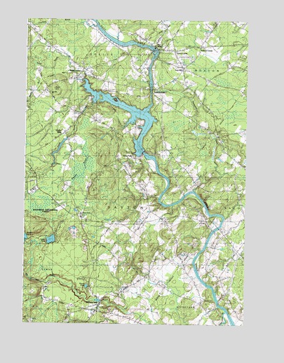
Bar Mills, ME USGS Topographic Map
Click on map above to begin viewing in our Map Viewer.

This topographic map contains these locations and features:
Feature Name Type Latitude Longitude GNIS ID View Map
Bar MillsPopulated PlaceN43.6131°W70.5498°561589View Map
Bar Mills DamDamN43.6132°W70.5530°1773575View Map
Bar Mills Post OfficePost OfficeN43.6126°W70.5463°1910748View Map
Bear HillSummitN43.5966°W70.6087°561834View Map
Bear Hill CemeteryCemeteryN43.5954°W70.6140°2737088View Map
Bear Hill ChurchChurchN43.5951°W70.6112°1910758View Map
Berry Memorial LibraryBuildingN43.6125°W70.5428°2738455View Map
Bradbury LotCemeteryN43.5950°W70.6115°2737101View Map
Briarwood Childrens House SchoolSchoolN43.5049°W70.5846°2738229View Map
Buxton Fire Department Station 2BuildingN43.6158°W70.5100°2552718View Map
Buxton Police DepartmentBuildingN43.6145°W70.5085°2735844View Map
Clarks MillsPopulated PlaceN43.5790°W70.6031°564055View Map
Community LibraryBuildingN43.5074°W70.5841°2738492View Map
Cooks BrookStreamN43.5865°W70.5606°564319View Map
Cooks Brook DamDamN43.5765°W70.6009°1774508View Map
Crockett BrookStreamN43.6223°W70.5856°564532View Map
Dayton Consolidated SchoolSchoolN43.5454°W70.5925°1910835View Map
Dennett LotCemeteryN43.5112°W70.5788°2736415View Map
Dennett LotCemeteryN43.5920°W70.5881°2736416View Map
Drug Rehabilitation Incorporated Day One ResidenceBuildingN43.6112°W70.5570°2655134View Map
Dunn LotCemeteryN43.5790°W70.5664°2736424View Map
Eliza Libby Elementary School (historical)SchoolN43.6125°W70.5460°1910859View Map
Emory CornerPopulated PlaceN43.6123°W70.5409°579296View Map
First Congregational ChurchChurchN43.6131°W70.5431°1910875View Map
Goodwins MillsPopulated PlaceN43.5087°W70.5817°566903View Map
Goodwins Mills CemeteryCemeteryN43.5054°W70.5824°2736895View Map
Goodwins Mills DamDamN43.5095°W70.5805°1774506View Map
Goodwins Mills Fire Station Rescue DepartmentBuildingN43.5078°W70.5810°2552873View Map
Greaton AirfieldAirportN43.5733°W70.5241°2443590View Map
Hanson LotCemeteryN43.6137°W70.6091°2736456View Map
Hill Day LotCemeteryN43.5143°W70.5869°2736463View Map
Hollis CenterPopulated PlaceN43.6051°W70.5931°568194View Map
Hollis Center Baptist ChurchChurchN43.6017°W70.5953°1910934View Map
Hollis Center Post OfficePost OfficeN43.6040°W70.5927°1910935View Map
Hollis Center Public LibraryBuildingN43.6001°W70.5955°2738431View Map
Hollis Fire Department and Rescue Station 1BuildingN43.6020°W70.5889°2552874View Map
Homestead CampgroundLocaleN43.5512°W70.5287°1910939View Map
Locke BrookStreamN43.6006°W70.5978°570145View Map
Lord Tripp LotCemeteryN43.5013°W70.6211°2736524View Map
Muddy BrookStreamN43.6029°W70.6228°571960View Map
Palmer Libby Hooper LotCemeteryN43.6171°W70.6174°2737173View Map
Parker PondLakeN43.5344°W70.6094°572988View Map
Riverside CemeteryCemeteryN43.6137°W70.5706°2737228View Map
Roberts CornerPopulated PlaceN43.6151°W70.5262°579659View Map
Roberts-Wadley PondReservoirN43.5331°W70.6244°1774505View Map
Roberts-Wadley Pond DamDamN43.5331°W70.6244°1774504View Map
Round PondLakeN43.5155°W70.5890°574491View Map
Saco River ReservoirReservoirN43.5708°W70.5580°1773574View Map
Saco River ReservoirReservoirN43.6134°W70.5495°1773576View Map
Salmon FallsPopulated PlaceN43.5962°W70.5537°574767View Map
Salmon Falls East Historic DistrictParkN43.5937°W70.5470°1911149View Map
Salmon Falls LibraryBuildingN43.5964°W70.5550°2738420View Map
Salmon Falls Resort Golf CourseLocaleN43.6076°W70.5570°1911150View Map
Salmon Falls West Historic DistrictParkN43.5967°W70.5542°1911152View Map
Skelton DamDamN43.5708°W70.5580°1773573View Map
Stackpole CreekStreamN43.5551°W70.5295°576216View Map
Stony BrookStreamN43.5940°W70.5851°576403View Map
Swan Pond BrookStreamN43.5001°W70.5134°576583View Map
Swan Pond CreekReservoirN43.5334°W70.5812°1774507View Map
Tory HillPopulated PlaceN43.6054°W70.5362°577213View Map
Tory Hill CemeteryCemeteryN43.6077°W70.5387°2737306View Map
Town of DaytonCivilN43.5462°W70.5729°582434View Map
Union FallsPopulated PlaceN43.5709°W70.5598°579784View Map
Wadley PondLakeN43.5331°W70.6244°577770View Map
WPEI-FM (Saco)TowerN43.5569°W70.5071°582086View Map

Note: Coordinates in the location and feature list above are referenced to NAD83 datum.


Copyright (C) 2008-2024 Ryan Niemi / Sunset Dynamics ... All Rights Reserved