TopoQuest Logo
Do you find TopoQuest useful?
Help keep TopoQuest running and adding new maps/features by donating!
Bitcoin:  19c7KJd3qBynnjoSw5npx9KScwjBe4ifkT
Litecoin:  LXs6TkuXGGXo1vDsWCkWVdjQX94eUKd6ui
Home View Maps Find Maps Find Places Resources & Links


Johnsburg, New York Topographic Map

USGS Map Title: Johnsburg, NY
USGS Map MRC: 43073E8
DRG (GeoTIFF) Download: o43073e8.tif


Neighboring USGS Topographic Map Quads:


  North Creek, NY  
43073F8
 

  Chestertown, NY  
43073F7


  Johnsburg, NY  
43073E8
 

  The Glen, NY  
43073E7


  Stony Creek, NY  
43073D8
 

  Warrensburg, NY  
43073D7


Map MRC Location:

N44°
W74°
N44°
W73°
H8 H7 H6 H5 H4 H3 H2 H1
G8 G7 G6 G5 G4 G3 G2 G1
F8 F7 F6 F5 F4 F3 F2 F1
E8 E7 E6 E5 E4 E3 E2 E1
D8 D7 D6 D5 D4 D3 D2 D1
C8 C7 C6 C5 C4 C3 C2 C1
B8 B7 B6 B5 B4 B3 B2 B1
A8 A7 A6 A5 A4 A3 A2 A1
N43°
W74°
N43°
W73°

Johnsburg, NY USGS 1:24K Topographic Map Preview:
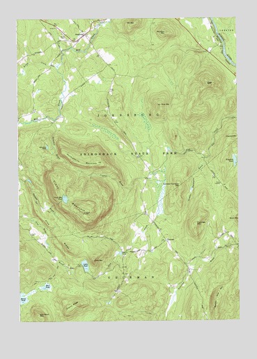
Johnsburg, NY USGS Topographic Map
Click on map above to begin viewing in our Map Viewer.

This topographic map contains these locations and features:
Feature Name Type Latitude Longitude GNIS ID View Map
Bates CemeteryCemeteryN43.6166°W73.9729°943159View Map
Camp DippikillLocaleN43.5567°W73.8848°945573View Map
Cherry RidgeRidgeN43.5062°W73.9690°946526View Map
Crane MountainSummitN43.5545°W73.9785°947697View Map
Crane Mountain PondLakeN43.5507°W73.9732°947698View Map
Crystal BrookStreamN43.5581°W73.9162°947887View Map
Dippikill PondLakeN43.5663°W73.8763°948470View Map
Gage MountainSummitN43.5978°W73.8918°950837View Map
Gobbler's Knob FarmLocaleN43.6158°W73.9786°2559399View Map
Huckleberry MountainSummitN43.5665°W73.9687°953374View Map
JohnsburgPopulated PlaceN43.6184°W73.9612°954101View Map
Johnsburg Volunteer Fire DepartmentBuildingN43.6159°W73.9649°2718660View Map
Kibby CreekStreamN43.6059°W73.9765°954590View Map
Little MountainSummitN43.5251°W73.9571°955602View Map
Little PondLakeN43.5233°W73.9623°955640View Map
Mill MountainSummitN43.6234°W73.9321°957254View Map
Mud PondLakeN43.5146°W73.9843°958072View Map
Number Nine MountainSummitN43.5092°W73.8871°959059View Map
Number Twentysix BrookStreamN43.5673°W73.8932°959064View Map
Number Twentysix MountainSummitN43.5551°W73.9082°959065View Map
Paintbed BrookStreamN43.5834°W73.9793°959763View Map
Partridge MountainSummitN43.5401°W73.8987°959959View Map
Pine MountainSummitN43.5892°W73.9182°960517View Map
Pine RidgeRidgeN43.5370°W73.9790°960542View Map
Russell CemeteryCemeteryN43.5195°W73.9397°2559609View Map
Snowshoe PondLakeN43.5721°W73.9830°965585View Map
Stockton MountainSummitN43.6192°W73.9154°966478View Map
ThurmanPopulated PlaceN43.5334°W73.9160°973156View Map
Town of ThurmanCivilN43.5039°W73.9809°979545View Map
Wolf Pond MountainSummitN43.5028°W73.9887°971580View Map

Note: Coordinates in the location and feature list above are referenced to NAD83 datum.


Copyright (C) 2008-2024 Ryan Niemi / Sunset Dynamics ... All Rights Reserved