TopoQuest Logo
Do you find TopoQuest useful?
Help keep TopoQuest running and adding new maps/features by donating!
Bitcoin:  19c7KJd3qBynnjoSw5npx9KScwjBe4ifkT
Litecoin:  LXs6TkuXGGXo1vDsWCkWVdjQX94eUKd6ui
Home View Maps Find Maps Find Places Resources & Links


Humboldt Peak, Nevada Topographic Map

USGS Map Title: Humboldt Peak, NV
USGS Map MRC: 40115H1
DRG (GeoTIFF) Download: o40115h1.tif


Neighboring USGS Topographic Map Quads:


  Herder Creek, NV  
41115A2
 

  Welcome, NV  
41115A1
 

  Wells, NV  
41114A8
 

  Tent Mountain, NV  
40115H2
 

  Humboldt Peak, NV  
40115H1
 

  Tobar, NV  
40114H8
 

  Secret Valley, NV  
40115G2
 

  Gordon Creek, NV  
40115G1
 

  Snow Water Lake, NV  
40114G8


Map MRC Location:

N41°
W116°
N41°
W115°
H8 H7 H6 H5 H4 H3 H2 H1
G8 G7 G6 G5 G4 G3 G2 G1
F8 F7 F6 F5 F4 F3 F2 F1
E8 E7 E6 E5 E4 E3 E2 E1
D8 D7 D6 D5 D4 D3 D2 D1
C8 C7 C6 C5 C4 C3 C2 C1
B8 B7 B6 B5 B4 B3 B2 B1
A8 A7 A6 A5 A4 A3 A2 A1
N40°
W116°
N40°
W115°

Humboldt Peak, NV USGS 1:24K Topographic Map Preview:
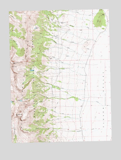
Humboldt Peak, NV USGS Topographic Map
Click on map above to begin viewing in our Map Viewer.

This topographic map contains these locations and features:
Feature Name Type Latitude Longitude GNIS ID View Map
Ballard RanchLocaleN40.9244°W115.0339°862709View Map
Bradish SpringSpringN40.9955°W115.0062°859000View Map
Chase CreekStreamN40.9005°W115.0403°859210View Map
Clover Valley School (historical)SchoolN40.9096°W115.0367°862421View Map
East Humboldt RangeRangeN40.9213°W115.1187°859626View Map
East Humboldts WildernessReserveN40.9466°W115.1243°863971View Map
Goodwin RanchLocaleN40.8941°W115.0398°862712View Map
Hole in the MountainArchN40.9471°W115.1234°860010View Map
Hole in the Mountain PeakSummitN40.9508°W115.1225°860011View Map
Humboldt PeakSummitN40.9010°W115.1195°860070View Map
Humboldt School (historical)SchoolN40.9694°W115.0195°862852View Map
K C RanchLocaleN40.9563°W115.0259°862707View Map
Leach CreekStreamN40.9371°W115.0317°860312View Map
Lizzies BasinBasinN40.9433°W115.0987°860393View Map
Longnecker RanchLocaleN40.9108°W115.0367°862711View Map
Ralph Fire LaneLocaleN40.9791°W115.0503°862420View Map
Renshaw CreekStreamN40.9546°W115.0253°861101View Map
Schoer CreekStreamN40.9999°W115.0125°861283View Map
Schumann RanchLocaleN40.9149°W115.0348°862710View Map
Shady CreekStreamN40.9474°W115.0481°861329View Map
Signal HillSummitN40.9880°W115.0139°861381View Map
South Fork Steele CreekStreamN40.9169°W115.0792°861496View Map
Steele LakeLakeN40.9149°W115.1133°861577View Map
Weeks CreekStreamN40.9244°W115.0334°861931View Map
Weeks RanchLocaleN40.9377°W115.0317°862708View Map
Winchell CreekStreamN40.9699°W115.0195°862074View Map
Winchell LakeLakeN40.9832°W115.0938°862075View Map
Wiseman CreekStreamN40.9741°W115.0159°862092View Map
Wood (historical)Populated PlaceN40.9027°W115.0387°862752View Map
Wood Post Office (historical)Post OfficeN40.9027°W115.0387°864259View Map
Woods CreekStreamN40.8963°W115.0398°862105View Map
Wright RanchLocaleN40.9774°W115.0128°862706View Map

Note: Coordinates in the location and feature list above are referenced to NAD83 datum.


Copyright (C) 2008-2024 Ryan Niemi / Sunset Dynamics ... All Rights Reserved