TopoQuest Logo
Do you find TopoQuest useful?
Help keep TopoQuest running and adding new maps/features by donating!
Bitcoin:  19c7KJd3qBynnjoSw5npx9KScwjBe4ifkT
Litecoin:  LXs6TkuXGGXo1vDsWCkWVdjQX94eUKd6ui
Home View Maps Find Maps Find Places Resources & Links


Hughesville, Maryland Topographic Map

USGS Map Title: Hughesville, MD
USGS Map MRC: 38076E7
DRG (GeoTIFF) Download: o38076e7.tif


Neighboring USGS Topographic Map Quads:


  Piscataway, MD  
38076F8
 

  Brandywine, MD  
38076F7
 

  Lower Marlboro, MD  
38076F6
 

  La Plata, MD  
38076E8
 

  Hughesville, MD  
38076E7
 

  Benedict, MD  
38076E6
 

  Popes Creek, MD  
38076D8
 

  Charlotte Hall, MD  
38076D7
 

  Mechanicsville, MD  
38076D6


Map MRC Location:

N39°
W77°
N39°
W76°
H8 H7 H6 H5 H4 H3 H2 H1
G8 G7 G6 G5 G4 G3 G2 G1
F8 F7 F6 F5 F4 F3 F2 F1
E8 E7 E6 E5 E4 E3 E2 E1
D8 D7 D6 D5 D4 D3 D2 D1
C8 C7 C6 C5 C4 C3 C2 C1
B8 B7 B6 B5 B4 B3 B2 B1
A8 A7 A6 A5 A4 A3 A2 A1
N38°
W77°
N38°
W76°

Hughesville, MD USGS 1:24K Topographic Map Preview:
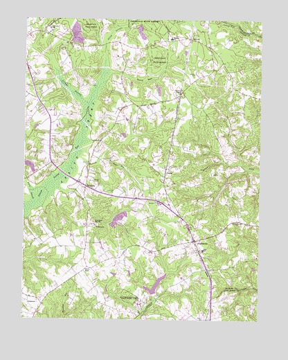
Hughesville, MD USGS Topographic Map
Click on map above to begin viewing in our Map Viewer.

This topographic map contains these locations and features:
Feature Name Type Latitude Longitude GNIS ID View Map
AAA TransportBuildingN38.5283°W76.7811°2773536View Map
Belle Ridge FarmsPopulated PlaceN38.5032°W76.8205°1676966View Map
BellewoodPopulated PlaceN38.6126°W76.8533°1676967View Map
Bowen EstatesPopulated PlaceN38.5957°W76.7566°1676973View Map
Breezy KnollsPopulated PlaceN38.5040°W76.7639°1697318View Map
Briar RidgePopulated PlaceN38.5612°W76.8236°1676975View Map
BryantownPopulated PlaceN38.5551°W76.8419°589841View Map
Bryantown BridgeBridgeN38.5643°W76.8402°583450View Map
Bryantown Census Designated PlaceCensusN38.5498°W76.8429°2629790View Map
Bryantown EstatesPopulated PlaceN38.5451°W76.8047°1676977View Map
Bryantown HillsPopulated PlaceN38.5407°W76.8575°1676978View Map
Bryantown Historic DistrictParkN38.5546°W76.8425°1676979View Map
Bryantown Post OfficePost OfficeN38.5559°W76.8448°1676980View Map
Burnt StoreLocaleN38.5218°W76.8405°583496View Map
Cameron RidgePopulated PlaceN38.5051°W76.8241°1676982View Map
Carrico Mill EstatesPopulated PlaceN38.5004°W76.8047°1676984View Map
Charles County GardensPopulated PlaceN38.5871°W76.8666°1676993View Map
Clayton Run EstatesPopulated PlaceN38.5898°W76.7983°1676998View Map
Devils NestBasinN38.5996°W76.8116°584099View Map
District 8, BryantownCivilN38.5602°W76.8513°1929691View Map
Edelen EstatesPopulated PlaceN38.5487°W76.8316°1677011View Map
Forest EstatesPopulated PlaceN38.6168°W76.8239°1677014View Map
Forest Glen EstatesPopulated PlaceN38.6151°W76.8164°1677015View Map
Forest ParkPopulated PlaceN38.5951°W76.8675°1677016View Map
Forest Park Baptist ChurchChurchN38.5868°W76.8594°1677017View Map
Gallant AcresPopulated PlaceN38.5876°W76.8075°1677020View Map
Gallant GreenLocaleN38.5940°W76.7927°584544View Map
Gallant Green WoodsPopulated PlaceN38.5854°W76.7747°1677022View Map
Gilbert PondReservoirN38.5144°W76.8044°594288View Map
Grace Brethren ChurchChurchN38.5726°W76.8611°1677029View Map
Grace Christian Academy of MarylandSchoolN38.5740°W76.8601°2132382View Map
Green SpringPopulated PlaceN38.6004°W76.7750°1677034View Map
GrosstownPopulated PlaceN38.5065°W76.8716°590391View Map
Hickory ThicketPopulated PlaceN38.5912°W76.8033°1677042View Map
Hidden ValleyPopulated PlaceN38.5676°W76.7877°1677043View Map
HughesvillePopulated PlaceN38.5326°W76.7839°590512View Map
Hughesville Census Designated PlaceCensusN38.5376°W76.7748°2389957View Map
Hughesville Company 2 Fire StationBuildingN38.5332°W76.7814°1677046View Map
Hughesville High SchoolSchoolN38.5287°W76.7797°1677047View Map
Hughesville Industrial ParkLocaleN38.5335°W76.7733°1677048View Map
Hughesville ManorPopulated PlaceN38.5229°W76.7800°1677052View Map
Hughesville PondReservoirN38.5483°W76.8030°1677049View Map
Hughesville Pond Recreation AreaParkN38.5485°W76.8039°1677050View Map
Hughesville Post OfficePost OfficeN38.5352°W76.7731°1677051View Map
Hughesville Volunteer Fire Department and Emergency Medical ServicesBuildingN38.5330°W76.7814°2087269View Map
Hunters FarmsPopulated PlaceN38.5612°W76.8372°1677053View Map
Independence VillagePopulated PlaceN38.5037°W76.8030°1677103View Map
Jameson DamDamN38.5135°W76.8080°594287View Map
Karen KnollsPopulated PlaceN38.5104°W76.7766°1677062View Map
Kindy HookPopulated PlaceN38.5293°W76.8416°1677063View Map
KnollandPopulated PlaceN38.5051°W76.7522°1697378View Map
MalcolmPopulated PlaceN38.6168°W76.7869°590724View Map
Malcolm Elementary SchoolSchoolN38.6169°W76.7977°585667View Map
MandleysPopulated PlaceN38.6004°W76.8480°1677072View Map
MasonsPopulated PlaceN38.5593°W76.8002°590758View Map
McKays Plaza Shopping CenterLocaleN38.5079°W76.7733°1697390View Map
Meadow Creek ManorPopulated PlaceN38.6068°W76.8191°1677076View Map
MeadowbrookPopulated PlaceN38.5918°W76.8636°1677077View Map
Metro Gun ClubLocaleN38.6187°W76.8150°1677079View Map
Middleton's Cedar Hill FarmLocaleN38.5847°W76.8614°2705144View Map
Mill Dam RunStreamN38.5537°W76.8639°585868View Map
New Covenant ChurchChurchN38.5996°W76.8722°1677092View Map
North Indian Creek EstatesPopulated PlaceN38.5101°W76.7664°1697406View Map
Notre Dame High SchoolSchoolN38.5401°W76.8375°586262View Map
Oak EstatesPopulated PlaceN38.5015°W76.7850°1677098View Map
Oakland AcresPopulated PlaceN38.5021°W76.7794°1677100View Map
Old Field ChurchChurchN38.5404°W76.7605°586302View Map
Old Fields Episcopal Church CemeteryCemeteryN38.5408°W76.7607°1677102View Map
Park EstatesPopulated PlaceN38.6210°W76.7805°1677110View Map
Pine Grove EstatesPopulated PlaceN38.5193°W76.7650°1677119View Map
Piney BranchStreamN38.5476°W76.8702°586535View Map
Plainview GardensPopulated PlaceN38.5010°W76.7894°1677120View Map
RidgeviewPopulated PlaceN38.5368°W76.8205°1677126View Map
Saint Charles Church of the NazareneChurchN38.5818°W76.8619°1677131View Map
Saint Mary Catholic ChurchChurchN38.5396°W76.8369°1677138View Map
Saint Mary's CemeteryCemeteryN38.5392°W76.8382°1677139View Map
Saint Mary's SchoolSchoolN38.5403°W76.8381°587106View Map
Saint Peter's CemeteryCemeteryN38.6196°W76.8652°1677142View Map
Saint Peters Catholic ChurchChurchN38.6201°W76.8614°1677141View Map
Saint Peters SchoolSchoolN38.6210°W76.8619°587145View Map
Sandy Level EstatesPopulated PlaceN38.5646°W76.8164°1677143View Map
Serenity WoodsPopulated PlaceN38.5046°W76.8402°1677144View Map
Smoots Pond RunStreamN38.5001°W76.8122°587410View Map
Society of Friends CemeteryCemeteryN38.5311°W76.7823°2780645View Map
Sothorons Desire (historical)LocaleN38.5043°W76.7664°1697444View Map
Southern Maryland Public Works CampLocaleN38.5096°W76.8180°587478View Map
SunnysidePopulated PlaceN38.5335°W76.8664°1677154View Map
SylvanhurstPopulated PlaceN38.6237°W76.7747°1677160View Map
T C Martin Elementary SchoolSchoolN38.5394°W76.8427°1677161View Map
Three BrothersPopulated PlaceN38.5729°W76.7961°1677165View Map
Timbuktu Arabian Horse FarmLocaleN38.5531°W76.8744°2662937View Map
Timbuktu Arabian Horse FarmLocaleN38.5531°W76.8744°2651620View Map
Underwood (historical)Populated PlaceN38.5071°W76.7511°1697458View Map
Walnut HillsPopulated PlaceN38.5126°W76.7716°1677176View Map
WNTL-AM (Indian Head)TowerN38.5648°W76.8166°598428View Map
Wolf Den BranchStreamN38.6221°W76.8202°598271View Map
Woodridge AcresPopulated PlaceN38.5587°W76.7816°1677188View Map
WXTR-FM (Waldorf)TowerN38.6187°W76.8447°598502View Map
Zekiah ValleyPopulated PlaceN38.5707°W76.8575°1677190View Map

Note: Coordinates in the location and feature list above are referenced to NAD83 datum.


Copyright (C) 2008-2024 Ryan Niemi / Sunset Dynamics ... All Rights Reserved