TopoQuest Logo
Do you find TopoQuest useful?
Help keep TopoQuest running and adding new maps/features by donating!
Bitcoin:  19c7KJd3qBynnjoSw5npx9KScwjBe4ifkT
Litecoin:  LXs6TkuXGGXo1vDsWCkWVdjQX94eUKd6ui
Home View Maps Find Maps Find Places Resources & Links


Henryville, Indiana Topographic Map

USGS Map Title: Henryville, IN
USGS Map MRC: 38085E7
DRG (GeoTIFF) Download: o38085e7.tif


Neighboring USGS Topographic Map Quads:


  Little York, IN  
38085F8
 

  Scottsburg, IN  
38085F7
 

  Blocher, IN  
38085F6
 

  South Boston, IN  
38085E8
 

  Henryville, IN  
38085E7
 

  Otisco, IN  
38085E6
 

  Borden, IN  
38085D8
 

  Speed, IN  
38085D7
 

  Charlestown, IN  
38085D6


Map MRC Location:

N39°
W86°
N39°
W85°
H8 H7 H6 H5 H4 H3 H2 H1
G8 G7 G6 G5 G4 G3 G2 G1
F8 F7 F6 F5 F4 F3 F2 F1
E8 E7 E6 E5 E4 E3 E2 E1
D8 D7 D6 D5 D4 D3 D2 D1
C8 C7 C6 C5 C4 C3 C2 C1
B8 B7 B6 B5 B4 B3 B2 B1
A8 A7 A6 A5 A4 A3 A2 A1
N38°
W86°
N38°
W85°

Henryville, IN USGS 1:24K Topographic Map Preview:
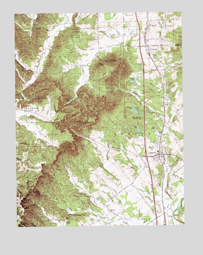
Henryville, IN USGS Topographic Map
Click on map above to begin viewing in our Map Viewer.

This topographic map contains these locations and features:
Feature Name Type Latitude Longitude GNIS ID View Map
Bartle KnobsRidgeN38.5051°W85.8611°430543View Map
Berry RunStreamN38.5042°W85.8502°430853View Map
Big Bass LakeReservoirN38.5850°W85.7863°431011View Map
Blue LickPopulated PlaceN38.5084°W85.8047°449620View Map
Blue Lick ChurchChurchN38.5120°W85.8080°431231View Map
Blue Lick CreekStreamN38.5009°W85.7580°431232View Map
Bowen LakeReservoirN38.5732°W85.8344°431391View Map
Bowen Lake DamDamN38.5742°W85.8330°447840View Map
Bowen RunStreamN38.5751°W85.8289°431392View Map
Bowers CreekStreamN38.5742°W85.8330°431399View Map
Bull RunStreamN38.5459°W85.7947°431795View Map
Calf RunStreamN38.5570°W85.7997°431960View Map
Caney ForkStreamN38.5148°W85.7611°432112View Map
Country LakeReservoirN38.5867°W85.7833°448574View Map
Country Lake Camp DamDamN38.5867°W85.7833°448573View Map
Cow RunStreamN38.5312°W85.7830°433054View Map
Fairview ChurchChurchN38.6162°W85.8130°434331View Map
Franke LakeReservoirN38.5558°W85.7832°434758View Map
Franke Lake DamDamN38.5551°W85.7833°448571View Map
Grain RunStreamN38.5576°W85.7600°435294View Map
Guernsey CreekStreamN38.5331°W85.7822°435546View Map
Hall RunStreamN38.5367°W85.8094°435617View Map
Henry BrookStreamN38.5156°W85.7625°436028View Map
HenryvillePopulated PlaceN38.5417°W85.7677°436039View Map
Henryville Census Designated PlaceCensusN38.5395°W85.7655°2393047View Map
Henryville Elementary SchoolSchoolN38.5356°W85.7736°446546View Map
Henryville Junior and Senior High SchoolSchoolN38.5356°W85.7736°446545View Map
Hilltop RunStreamN38.5301°W85.8255°436226View Map
Leaf RunStreamN38.6109°W85.7902°437696View Map
Left Branch Blue Lick CreekStreamN38.5045°W85.8069°437748View Map
Left DrainStreamN38.5103°W85.8383°437749View Map
Lodge CreekStreamN38.5198°W85.7775°438215View Map
Look RunStreamN38.5598°W85.8377°438297View Map
Meal RunStreamN38.5742°W85.7605°438951View Map
Middle Poplar BranchStreamN38.5626°W85.8741°439107View Map
Milk BrookStreamN38.5451°W85.7941°439143View Map
Mill BranchStreamN38.5639°W85.7605°439144View Map
Monroe Township Fire DepartmentBuildingN38.5371°W85.7670°2625815View Map
Monroe Township Volunteer Fire Department Station 2BuildingN38.6017°W85.7757°2626088View Map
Monroe Township Volunteer Fire Department Station 3BuildingN38.5197°W85.7988°2626066View Map
Mount Zion CemeteryCemeteryN38.5358°W85.7775°439726View Map
Mountain GroveStreamN38.5092°W85.8252°439780View Map
Mountain Grove CemeteryCemeteryN38.5133°W85.8196°439781View Map
New Chapel ChurchChurchN38.5939°W85.8250°440034View Map
New LibertyPopulated PlaceN38.5681°W85.8672°440074View Map
New Liberty FieldAirportN38.5571°W85.8653°2677008View Map
North Branch Big Ox CreekStreamN38.5909°W85.8591°440219View Map
North Fairview RunStreamN38.6112°W85.7969°440246View Map
Oak KnobSummitN38.5948°W85.8116°440441View Map
Oak LakeReservoirN38.5565°W85.7703°440442View Map
Oak RunStreamN38.6003°W85.8141°440455View Map
Out BrookStreamN38.5581°W85.8341°440775View Map
Pigeon Roost MemorialParkN38.6173°W85.7739°441126View Map
Pigeon Roost StationPopulated PlaceN38.6145°W85.7758°452177View Map
Pine KnobSummitN38.5964°W85.8077°441156View Map
Pine LakeReservoirN38.5538°W85.7673°441158View Map
Pine RunStreamN38.6048°W85.8100°441162View Map
Purdue University Forestry CampSchoolN38.5631°W85.7800°441659View Map
Rain RunStreamN38.5340°W85.7627°441743View Map
Right Branch Blue Lick CreekStreamN38.5045°W85.8066°442012View Map
Right DrainStreamN38.5103°W85.8383°442013View Map
Rock KnobSummitN38.5967°W85.8022°442204View Map
Roger CreekStreamN38.6217°W85.8616°442244View Map
Round KnobSummitN38.5198°W85.8597°442348View Map
Schlamm LakeReservoirN38.5674°W85.7858°448569View Map
Schlamm Lake DamDamN38.5667°W85.7833°448570View Map
Sheep BranchStreamN38.5526°W85.7816°443332View Map
Silver HillsRangeN38.5773°W85.8150°448365View Map
South Branch Big Ox CreekStreamN38.5909°W85.8591°443781View Map
South Fairview RunStreamN38.6109°W85.7941°443801View Map
Stick RunStreamN38.5856°W85.8205°444159View Map
Sticky BranchStreamN38.5045°W85.7944°444160View Map
Swing BrookStreamN38.6042°W85.8108°444494View Map
Township of MonroeCivilN38.5465°W85.7748°453636View Map
Try RunStreamN38.5017°W85.7789°444934View Map
UnderwoodPopulated PlaceN38.6037°W85.7744°445042View Map
Underwood DrainStreamN38.5939°W85.7633°445043View Map
Underwood RunStreamN38.6231°W85.7758°445044View Map
Vote RunStreamN38.5226°W85.7966°445322View Map
Weed RunStreamN38.5128°W85.7977°445635View Map
West Fork Silver CreekStreamN38.5939°W85.7633°445758View Map
Wheel RunStreamN38.5778°W85.7608°445881View Map
Willys ChapelChurchN38.5048°W85.8386°446115View Map
WMPI-FM (Scottsburg)TowerN38.6201°W85.7541°448922View Map
Wolf RunStreamN38.5426°W85.7639°446255View Map
Woof LakeReservoirN38.5496°W85.8602°2709544View Map
Wrong BranchStreamN38.5173°W85.8191°446344View Map

Note: Coordinates in the location and feature list above are referenced to NAD83 datum.


Copyright (C) 2008-2024 Ryan Niemi / Sunset Dynamics ... All Rights Reserved