TopoQuest Logo
Do you find TopoQuest useful?
Help keep TopoQuest running and adding new maps/features by donating!
Bitcoin:  19c7KJd3qBynnjoSw5npx9KScwjBe4ifkT
Litecoin:  LXs6TkuXGGXo1vDsWCkWVdjQX94eUKd6ui
Home View Maps Find Maps Find Places Resources & Links


Hartland, Vermont Topographic Map

USGS Map Title: Hartland, VT
USGS Map MRC: 43072E4
DRG (GeoTIFF) Download: o43072e4.tif


Neighboring USGS Topographic Map Quads:


  Woodstock North, VT  
43072F5
 

  Quechee, VT  
43072F4
 

  Hanover, NH  
43072F3
 

  Woodstock South, VT  
43072E5
 

  Hartland, VT  
43072E4
 

  North Hartland, VT  
43072E3
 

  Cavendish, VT  
43072D5
 

  Windsor, VT  
43072D4
 

  Claremont North, NH  
43072D3


Map MRC Location:

N44°
W73°
N44°
W72°
H8 H7 H6 H5 H4 H3 H2 H1
G8 G7 G6 G5 G4 G3 G2 G1
F8 F7 F6 F5 F4 F3 F2 F1
E8 E7 E6 E5 E4 E3 E2 E1
D8 D7 D6 D5 D4 D3 D2 D1
C8 C7 C6 C5 C4 C3 C2 C1
B8 B7 B6 B5 B4 B3 B2 B1
A8 A7 A6 A5 A4 A3 A2 A1
N43°
W73°
N43°
W72°

Hartland, VT USGS 1:24K Topographic Map Preview:
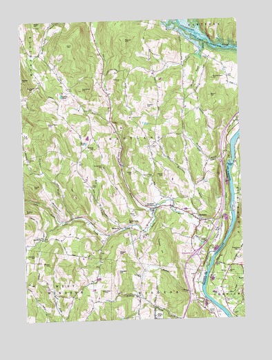
Hartland, VT USGS Topographic Map
Click on map above to begin viewing in our Map Viewer.

This topographic map contains these locations and features:
Feature Name Type Latitude Longitude GNIS ID View Map
Advent HillSummitN43.6003°W72.4424°1456114View Map
Alder Meadow BrookStreamN43.5470°W72.4237°1456130View Map
Aldrich CemeteryCemeteryN43.5437°W72.4349°1456134View Map
Barron HillSummitN43.6168°W72.4393°1456275View Map
Bashan BrookStreamN43.5109°W72.3981°1456287View Map
Baylies HillSummitN43.6015°W72.4997°1456300View Map
Beaver PondLakeN43.5736°W72.4639°1456356View Map
Blood HillSummitN43.5231°W72.4851°1456479View Map
Breeze HillSummitN43.5717°W72.4583°1456559View Map
Bronson DamDamN43.5234°W72.4662°1766758View Map
Cady BrookStreamN43.5415°W72.4754°1456713View Map
Center CemeteryCemeteryN43.5720°W72.4256°1456812View Map
Chase CemeteryCemeteryN43.5017°W72.3816°866117View Map
Cobb HillSummitN43.5616°W72.4371°1456936View Map
Cotton HillSummitN43.5892°W72.4277°1457027View Map
Crystal PondLakeN43.5937°W72.4769°1457067View Map
Cutts CemeteryCemeteryN43.6012°W72.3809°1457086View Map
Densmore BrookStreamN43.5426°W72.4712°1457147View Map
Densmore CemeteryCemeteryN43.5675°W72.4974°1457148View Map
Densmore HillSummitN43.5501°W72.4827°1457149View Map
Dunham HillSummitN43.5979°W72.4958°1457214View Map
Fareham HillSummitN43.5643°W72.4539°1457409View Map
FieldsvillePopulated PlaceN43.5387°W72.4434°1460417View Map
Freeman CemeteryCemeteryN43.5197°W72.3834°866972View Map
Freeman HillSummitN43.5276°W72.3768°866973View Map
French HillSummitN43.5461°W72.4993°1457492View Map
Frizzel CemeteryCemeteryN43.6098°W72.4756°1922367View Map
Fulling BrookStreamN43.6165°W72.3943°1457503View Map
Gallup CemeteryCemeteryN43.5656°W72.4678°1457509View Map
Garvin HillSummitN43.5817°W72.4845°1457523View Map
Gill CemeteryCemeteryN43.5969°W72.4720°1457544View Map
Grout HillSummitN43.5931°W72.3912°1457660View Map
Grout SchoolSchoolN43.6090°W72.3915°1457662View Map
Hall HillSummitN43.5528°W72.4707°1457698View Map
Harlow BrookStreamN43.6101°W72.3965°1457737View Map
Hart IslandIslandN43.5237°W72.3945°865175View Map
HartlandPopulated PlaceN43.5406°W72.3990°1457747View Map
Hartland CemeteryCemeteryN43.5403°W72.3953°1922392View Map
Hartland Census Designated PlaceCensusN43.5423°W72.4001°2586637View Map
Hartland Elementary SchoolSchoolN43.5381°W72.3942°1922393View Map
Hartland Four CornersPopulated PlaceN43.5465°W72.4245°1457748View Map
Hartland Four Corners Post OfficePost OfficeN43.5475°W72.4217°1922394View Map
Hartland HillSummitN43.5964°W72.4646°1457749View Map
Hartland Post OfficePost OfficeN43.5407°W72.3995°1922396View Map
Hartland Volunteer Fire Department and Rescue Squad Incorporated Station 1BuildingN43.5446°W72.4078°2121309View Map
Hoisington CemeteryCemeteryN43.5187°W72.4335°1457860View Map
Holbrook HillSummitN43.5121°W72.4548°1457862View Map
Hour Glass Country Club and Golf CourseLocaleN43.5028°W72.3898°1922409View Map
Interchange 9CrossingN43.5276°W72.4023°1922420View Map
JennevillePopulated PlaceN43.5345°W72.4893°1460428View Map
Jenneville CemeteryCemeteryN43.5346°W72.4887°1922426View Map
Kent HillSummitN43.6148°W72.4727°1458071View Map
Ledge IslandIslandN43.5648°W72.3795°867978View Map
Lulls BrookStreamN43.5276°W72.3923°1458313View Map
Mace HillSummitN43.5601°W72.4193°1458326View Map
Martins Mill Covered BridgeBridgeN43.5326°W72.3959°1922459View Map
McArthur BrookStreamN43.5406°W72.3804°1458389View Map
Meadowbrook SchoolSchoolN43.5465°W72.4254°2427571View Map
North Hartland ReservoirReservoirN43.6175°W72.3938°1458738View Map
Plains CemeteryCemeteryN43.5603°W72.3865°1458992View Map
Quaker-Willard CemeteryCemeteryN43.5600°W72.4251°1459120View Map
Rabbit HillSummitN43.5284°W72.4458°1459130View Map
Richardson HillSummitN43.6004°W72.3894°1459175View Map
Scott HillSummitN43.5567°W72.4940°1459432View Map
Shepherd BrookStreamN43.5723°W72.3801°1459490View Map
Snody Dock LighthouseBuildingN43.6001°W72.4329°1460359View Map
Southeast State Correctional Facility - WindsorBuildingN43.5008°W72.4255°2121205View Map
Sumner FallsFallsN43.5645°W72.3809°870269View Map
Tinkham HillSummitN43.5273°W72.4201°1459911View Map
Town Farm HillSummitN43.5411°W72.4406°1459934View Map
Town of HartlandCivilN43.5741°W72.4348°1462117View Map
Unitarian Universalist ChurchChurchN43.5459°W72.4262°1922671View Map
Verdun HillSummitN43.5274°W72.4943°1460017View Map
Walker CemeteryCemeteryN43.5356°W72.4321°1460043View Map
Weed BrookStreamN43.5376°W72.4429°1460095View Map
Weed CemeteryCemeteryN43.5559°W72.4606°1460096View Map
Weeden HillSummitN43.5202°W72.4464°1460097View Map
Windsor Country ClubLocaleN43.5017°W72.3934°1461809View Map
WMXR-FM (Woodstock)TowerN43.6048°W72.4670°1462016View Map

Note: Coordinates in the location and feature list above are referenced to NAD83 datum.


Copyright (C) 2008-2024 Ryan Niemi / Sunset Dynamics ... All Rights Reserved