TopoQuest Logo
Do you find TopoQuest useful?
Help keep TopoQuest running and adding new maps/features by donating!
Bitcoin:  19c7KJd3qBynnjoSw5npx9KScwjBe4ifkT
Litecoin:  LXs6TkuXGGXo1vDsWCkWVdjQX94eUKd6ui
Home View Maps Find Maps Find Places Resources & Links


Groton, Vermont Topographic Map

USGS Map Title: Groton, VT
USGS Map MRC: 44072B2
DRG (GeoTIFF) Download: o44072b2.tif


Neighboring USGS Topographic Map Quads:


  Marshfield, VT  
44072C3


  Knox Mountain, VT  
44072B3
 

  Groton, VT  
44072B2
 

  Woodsville, NH  
44072B1
 

  West Topsham, VT  
44072A3
 

  East Corinth, VT  
44072A2
 

  Newbury, VT  
44072A1


Map MRC Location:

N45°
W73°
N45°
W72°
H8 H7 H6 H5 H4 H3 H2 H1
G8 G7 G6 G5 G4 G3 G2 G1
F8 F7 F6 F5 F4 F3 F2 F1
E8 E7 E6 E5 E4 E3 E2 E1
D8 D7 D6 D5 D4 D3 D2 D1
C8 C7 C6 C5 C4 C3 C2 C1
B8 B7 B6 B5 B4 B3 B2 B1
A8 A7 A6 A5 A4 A3 A2 A1
N44°
W73°
N44°
W72°

Groton, VT USGS 1:24K Topographic Map Preview:
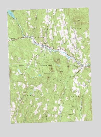
Groton, VT USGS Topographic Map
Click on map above to begin viewing in our Map Viewer.

This topographic map contains these locations and features:
Feature Name Type Latitude Longitude GNIS ID View Map
Blue MountainSummitN44.2359°W72.1376°1456490View Map
Bonazzi QuarryMineN44.1920°W72.2068°1919446View Map
Burnham MountainSummitN44.1740°W72.1907°1456668View Map
Clark Hatch BrookStreamN44.2040°W72.1807°1456900View Map
Clark Site Number 2 DamDamN44.1567°W72.2195°1766750View Map
Darius James BrookStreamN44.2031°W72.1707°1457111View Map
Dawes BrookStreamN44.1692°W72.1629°1457123View Map
East BrookStreamN44.2040°W72.1884°1457261View Map
Eastman PondLakeN44.1312°W72.1739°1457327View Map
Egypt BrookStreamN44.1351°W72.1431°1457349View Map
First Baptist ChurchChurchN44.2103°W72.1959°1919508View Map
Galusha HillSummitN44.1512°W72.1993°1457515View Map
Gibson Granite QuarryMineN44.2331°W72.1473°1919520View Map
GrotonPopulated PlaceN44.2103°W72.1954°1457657View Map
Groton - Ryegate Emergency Medical ServicesBuildingN44.2117°W72.1969°2578112View Map
Groton Census Designated PlaceCensusN44.2140°W72.1968°2586635View Map
Groton ConstableBuildingN44.2115°W72.1974°2752736View Map
Groton Post OfficePost OfficeN44.2100°W72.1930°1919526View Map
Groton Village CemeteryCemeteryN44.2063°W72.1829°1919528View Map
Groton Volunteer Fire DepartmentBuildingN44.2116°W72.1970°2121411View Map
Heath CemeteryCemeteryN44.2484°W72.2190°1919543View Map
Hillside CemeteryCemeteryN44.1848°W72.1336°1457835View Map
Huckins - Caldwell Hill CemeteryCemeteryN44.1655°W72.2276°1921438View Map
Jefferson HillSummitN44.1578°W72.1493°1457996View Map
Jefferson Hill CemeteryCemeteryN44.1657°W72.1424°1921449View Map
Keenam BrookLakeN44.2037°W72.1837°1458057View Map
Lime Kiln CemeteryCemeteryN44.1372°W72.1818°1921464View Map
Lime Kiln School (historical)SchoolN44.1378°W72.1731°1921465View Map
Mason MountainSummitN44.1323°W72.1937°1458375View Map
Melvin HillSummitN44.1803°W72.1701°1458418View Map
Newbury Municipal ForestForestN44.1481°W72.1601°1921474View Map
North Branch Wells RiverStreamN44.2176°W72.2118°1458705View Map
North Ryegate CemeteryCemeteryN44.2306°W72.1601°1919622View Map
Norwich ReservoirReservoirN44.1570°W72.2189°1766573View Map
Norwich Reservoir DamDamN44.1567°W72.2195°1766572View Map
Pine Mountain Wildlife Management AreaParkN44.1801°W72.1859°1458978View Map
Pine MountainsSummitN44.1848°W72.1862°1458979View Map
Pinehurst CemeteryCemeteryN44.1856°W72.1279°1458982View Map
Powder Spring BrookStreamN44.1253°W72.2412°1459066View Map
Red BrookStreamN44.2448°W72.2040°1459154View Map
Ricker MillsPopulated PlaceN44.2387°W72.2393°1459183View Map
Ricker PondLakeN44.2462°W72.2441°1459185View Map
Round Top CemeteryCemeteryN44.1360°W72.1956°1921538View Map
Ryegate QuarryMineN44.1917°W72.1606°1919676View Map
School Number 3 (historical)SchoolN44.2126°W72.1523°1919696View Map
Scotch HollowValleyN44.1401°W72.1420°1459430View Map
Scott BrookStreamN44.1873°W72.1384°1459431View Map
South Branch Wells RiverStreamN44.2198°W72.2204°1459574View Map
South Groton School (historical)SchoolN44.1909°W72.2179°1919709View Map
South RyegatePopulated PlaceN44.1884°W72.1409°1459613View Map
South Ryegate Post OfficePost OfficeN44.1872°W72.1399°1919712View Map
South Ryegate Presbyterian ChurchChurchN44.1870°W72.1404°1919713View Map
South Ryegate Public LibraryBuildingN44.1884°W72.1351°1919714View Map
Tannery BrookStreamN44.2078°W72.1901°1459821View Map
Town of TopshamCivilN44.1338°W72.2498°1462228View Map
West GrotonPopulated PlaceN44.2181°W72.2434°1460141View Map
Whitcher MountainSummitN44.1923°W72.1757°1460213View Map
White HillSummitN44.1853°W72.1606°1460222View Map

Note: Coordinates in the location and feature list above are referenced to NAD83 datum.


Copyright (C) 2008-2024 Ryan Niemi / Sunset Dynamics ... All Rights Reserved