TopoQuest Logo
Do you find TopoQuest useful?
Help keep TopoQuest running and adding new maps/features by donating!
Bitcoin:  19c7KJd3qBynnjoSw5npx9KScwjBe4ifkT
Litecoin:  LXs6TkuXGGXo1vDsWCkWVdjQX94eUKd6ui
Home View Maps Find Maps Find Places Resources & Links


Greenfield, New Hampshire Topographic Map

USGS Map Title: Greenfield, NH
USGS Map MRC: 42071H7
DRG (GeoTIFF) Download: o42071h7.tif


Neighboring USGS Topographic Map Quads:


  Hillsboro, NH  
43071A8
 

  Deering, NH  
43071A7
 

  Weare, NH  
43071A6
 

  Peterborough North, NH  
42071H8
 

  Greenfield, NH  
42071H7
 

  New Boston, NH  
42071H6
 

  Peterborough South, NH  
42071G8
 

  Greenville, NH  
42071G7
 

  Milford, NH  
42071G6


Map MRC Location:

N43°
W72°
N43°
W71°
H8 H7 H6 H5 H4 H3 H2 H1
G8 G7 G6 G5 G4 G3 G2 G1
F8 F7 F6 F5 F4 F3 F2 F1
E8 E7 E6 E5 E4 E3 E2 E1
D8 D7 D6 D5 D4 D3 D2 D1
C8 C7 C6 C5 C4 C3 C2 C1
B8 B7 B6 B5 B4 B3 B2 B1
A8 A7 A6 A5 A4 A3 A2 A1
N42°
W72°
N42°
W71°

Greenfield, NH USGS 1:24K Topographic Map Preview:
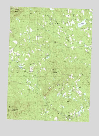
Greenfield, NH USGS Topographic Map
Click on map above to begin viewing in our Map Viewer.

This topographic map contains these locations and features:
Feature Name Type Latitude Longitude GNIS ID View Map
Badger PondLakeN42.9127°W71.7688°865315View Map
Blanchard HillSummitN42.9351°W71.8379°865656View Map
Bullard HillSummitN42.9937°W71.8465°865848View Map
Crotched MountainSummitN42.9984°W71.8737°866414View Map
Crotched Mountain SchoolSchoolN42.9721°W71.8741°1915310View Map
Crotched Mountain Specialty HospitalHospitalN42.9718°W71.8747°1915309View Map
First Unitarian ChurchChurchN42.9873°W71.8123°1915364View Map
FrancestownPopulated PlaceN42.9876°W71.8126°866961View Map
Francestown Elementary SchoolSchoolN42.9814°W71.8025°1915369View Map
Francestown Police DepartmentBuildingN42.9873°W71.8116°2752876View Map
Francestown Post OfficePost OfficeN42.9842°W71.8084°1915860View Map
Francestown Volunteer Fire DepartmentBuildingN42.9823°W71.8056°2605243View Map
Gould HillSummitN42.9284°W71.8617°867146View Map
GreenfieldPopulated PlaceN42.9506°W71.8723°867237View Map
Greenfield Police DepartmentBuildingN42.9509°W71.8728°2752993View Map
Greenfield Post OfficePost OfficeN42.9454°W71.8702°1915414View Map
Greenvale CemeteryCemeteryN42.9368°W71.8555°867247View Map
Haunted LakeLakeN42.9835°W71.7652°867407View Map
LyndeboroughPopulated PlaceN42.9076°W71.7665°868222View Map
Lyndeborough Center Historic DistrictParkN42.9062°W71.7662°1915534View Map
Lyndeborough Central SchoolSchoolN42.8816°W71.7857°1915535View Map
Lyndeborough Fire DepartmentBuildingN42.8782°W71.7825°2605032View Map
Lyndeborough MountainSummitN42.9290°W71.7981°868223View Map
Lyndeborough Police DepartmentBuildingN42.8792°W71.7842°2752808View Map
North Lyndeborough CemeteryCemeteryN42.9440°W71.7542°868792View Map
North Pack Monadnock MountainSummitN42.8862°W71.8656°868801View Map
Old Meeting House (historical)ChurchN42.9873°W71.8123°1915637View Map
Piscataquog MountainSummitN42.9306°W71.7734°869226View Map
Rand BrookStreamN42.9592°W71.7776°869432View Map
Rose MountainSummitN42.9320°W71.8048°869598View Map
RussellPopulated PlaceN42.9173°W71.8448°871225View Map
Souhegan River Watershed Dam Number 28DamN42.8851°W71.8129°1775521View Map
Souhegan River Watershed Dam Number 8DamN42.8851°W71.7679°1775605View Map
South Lyndeboro Post Office (historical)Post OfficeN42.8795°W71.7834°1915761View Map
South LyndeboroughPopulated PlaceN42.8801°W71.7837°870043View Map
South Lyndeborough CemeteryCemeteryN42.8812°W71.7680°870044View Map
Stimson HillSummitN42.8968°W71.7804°870179View Map
Swartz PondReservoirN42.9039°W71.7983°1775520View Map
Swartz Pond DamDamN42.9051°W71.7979°1775519View Map
The PinnacleSummitN42.9279°W71.7929°870395View Map
Town of FrancestownCivilN42.9958°W71.8152°873598View Map
Town of GreenfieldCivilN42.9401°W71.8704°873611View Map
Town of LyndeboroughCivilN42.9029°W71.7736°873655View Map
Union Congregational ChurchChurchN42.9512°W71.8717°1915807View Map
United Church of LyndeboroughChurchN42.9634°W71.7829°1915812View Map
Wapack National Wildlife RefugeParkN42.8875°W71.8660°871029View Map
Whiting BrookStreamN42.9851°W71.7684°870863View Map
Winn MountainSummitN42.9106°W71.8104°870949View Map
Wonderworks Learning CenterSchoolN42.9734°W71.8735°2499746View Map
Zephyr LakeLakeN42.9338°W71.8559°871026View Map

Note: Coordinates in the location and feature list above are referenced to NAD83 datum.


Copyright (C) 2008-2024 Ryan Niemi / Sunset Dynamics ... All Rights Reserved