TopoQuest Logo
Do you find TopoQuest useful?
Help keep TopoQuest running and adding new maps/features by donating!
Bitcoin:  19c7KJd3qBynnjoSw5npx9KScwjBe4ifkT
Litecoin:  LXs6TkuXGGXo1vDsWCkWVdjQX94eUKd6ui
Home View Maps Find Maps Find Places Resources & Links


Great East Lake, Maine Topographic Map

USGS Map Title: Great East Lake, ME
USGS Map MRC: 43070E8
DRG (GeoTIFF) Download: o43070e8.tif


Neighboring USGS Topographic Map Quads:


  Ossipee, NH  
43071F1
 

  West Newfield, ME  
43070F8
 

  Limerick, ME  
43070F7
 

  Sanbornville, NH  
43071E1
 

  Great East Lake, ME  
43070E8
 

  Mousam Lake, ME  
43070E7
 

  Farmington, NH  
43071D1
 

  Milton, NH  
43070D8
 

  Sanford, ME  
43070D7


Map MRC Location:

N44°
W71°
N44°
W70°
H8 H7 H6 H5 H4 H3 H2 H1
G8 G7 G6 G5 G4 G3 G2 G1
F8 F7 F6 F5 F4 F3 F2 F1
E8 E7 E6 E5 E4 E3 E2 E1
D8 D7 D6 D5 D4 D3 D2 D1
C8 C7 C6 C5 C4 C3 C2 C1
B8 B7 B6 B5 B4 B3 B2 B1
A8 A7 A6 A5 A4 A3 A2 A1
N43°
W71°
N43°
W70°

Great East Lake, ME USGS 1:24K Topographic Map Preview:
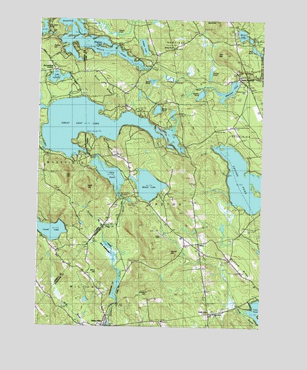
Great East Lake, ME USGS Topographic Map
Click on map above to begin viewing in our Map Viewer.

This topographic map contains these locations and features:
Feature Name Type Latitude Longitude GNIS ID View Map
ActonPopulated PlaceN43.5342°W70.9098°561080View Map
Acton Elementary SchoolSchoolN43.5069°W70.8972°1910721View Map
Acton Post OfficePost OfficeN43.5341°W70.9149°1910723View Map
Acton Public LibraryBuildingN43.5323°W70.9094°1910724View Map
Acton RidgeRidgeN43.5976°W70.9640°561081View Map
Acton Volunteer Fire DepartmentBuildingN43.5304°W70.9079°2553077View Map
Balch PondLakeN43.6148°W70.9753°865340View Map
Balch PondReservoirN43.6055°W70.9381°561491View Map
Balch Pond Outlet DamDamN43.6055°W70.9381°1773587View Map
Berry CemeteryCemeteryN43.5331°W70.9714°1914692View Map
Berry HillSummitN43.5223°W70.9659°865555View Map
Bond MountainSummitN43.6247°W70.9017°562725View Map
Buzzy's FieldAirportN43.6099°W70.9697°582106View Map
Camp Sa -Gis -CaLocaleN43.5673°W70.9615°563414View Map
Copp BrookStreamN43.5945°W70.9998°866332View Map
Copp BrookStreamN43.5726°W70.9953°866333View Map
Davis CemeteryCemeteryN43.5776°W70.8927°2736408View Map
Davis HillSummitN43.5567°W70.9742°866499View Map
Farnham BrookStreamN43.5398°W70.9631°866841View Map
Folsom PondLakeN43.6191°W70.9574°566365View Map
Garland Road CemeteryCemeteryN43.6212°W70.9278°2736884View Map
Gerrish MountainSummitN43.5299°W70.9262°566762View Map
Gile MountainSummitN43.6107°W70.8954°566788View Map
Great East LakeReservoirN43.5819°W70.9724°567137View Map
Great East Lake BeachBeachN43.5931°W70.9753°1915978View Map
Great East Lake DamDamN43.5700°W70.9725°1774956View Map
Great Hollow Road Number 1 CemeteryCemeteryN43.5828°W70.8826°2736445View Map
Great Hollow Road Number 2 CemeteryCemeteryN43.5805°W70.8793°2736446View Map
Green CemeteryCemeteryN43.5888°W70.8907°2736447View Map
Hansen PondLakeN43.5947°W70.9093°567575View Map
Hidden LakeLakeN43.6141°W70.9417°567999View Map
Highland Grove CemeteryCemeteryN43.5959°W70.8845°568035View Map
Hill Keys CemeteryCemeteryN43.6150°W70.9259°2736465View Map
Horn HillSummitN43.5704°W70.9570°568262View Map
Horn PondReservoirN43.5620°W70.9599°867601View Map
Horn Pond DamDamN43.5551°W70.9545°1775160View Map
Hubbard RidgeRidgeN43.5248°W70.8867°568426View Map
Hussey HillSummitN43.5143°W70.9375°568518View Map
Lake IvanhoeLakeN43.6012°W70.9896°867739View Map
Lake Ivanhoe BeachBeachN43.6017°W70.9834°1916013View Map
Loon PondLakeN43.5073°W70.8769°570376View Map
Maple Grove CemeteryCemeteryN43.5053°W70.9000°2736529View Map
Maple Grove ChurchChurchN43.5065°W70.8967°570731View Map
McCutcheon CornersLocaleN43.6048°W70.9912°868324View Map
Milton Fire Rescue Station 2BuildingN43.5016°W70.9597°2605320View Map
Milton MillsPopulated PlaceN43.5012°W70.9637°868472View Map
Milton Mills Census Designated PlaceCensusN43.5039°W70.9654°2629729View Map
Mirror LakeLakeN43.6192°W70.8868°571447View Map
Moose PondLakeN43.5881°W70.9337°571614View Map
Mud PondLakeN43.6127°W70.8789°571882View Map
Nadeau's AirportAirportN43.5375°W70.9297°1911022View Map
North ShapleighPopulated PlaceN43.6017°W70.8878°572410View Map
Oak HillSummitN43.5615°W70.9851°868871View Map
Patch CemeteryCemeteryN43.5813°W70.8989°2737178View Map
Perkins HillSummitN43.6142°W70.9940°869082View Map
Ross CemeteryCemeteryN43.5857°W70.8900°2737235View Map
Round PondLakeN43.6170°W70.8820°574493View Map
Rowe DamDamN43.5097°W70.9545°1773611View Map
Salmon Falls River 10 DamDamN43.5101°W70.9545°1775335View Map
Salmon Falls River ReservoirReservoirN43.5101°W70.9545°1775336View Map
Salmon Falls River ReservoirReservoirN43.5097°W70.9545°1773612View Map
Shady NookPopulated PlaceN43.6134°W70.9253°579687View Map
Shapleigh PondReservoirN43.5946°W70.8949°575306View Map
Shapleigh Pond DamDamN43.6008°W70.8899°1774083View Map
Shepherd IslandIslandN43.6140°W70.9637°575383View Map
Smarts PondLakeN43.6031°W70.9043°575581View Map
South ActonPopulated PlaceN43.5051°W70.9031°579708View Map
Spinney ChurchChurchN43.5342°W70.9726°870090View Map
Spinney Church (historical)ChurchN43.5337°W70.9717°1916124View Map
Square PondReservoirN43.5597°W70.8847°576181View Map
Square Pond Seaplane BaseAirportN43.5672°W70.8834°582230View Map
Stump PondLakeN43.6198°W70.9756°576462View Map
Stump PondLakeN43.6242°W70.9851°870241View Map
Swan PondLakeN43.6001°W70.9368°576580View Map
Sylvester CemeteryCemeteryN43.5771°W70.8776°2737287View Map
Town of ActonCivilN43.5299°W70.9207°582315View Map
Welch CemeteryCemeteryN43.5778°W70.8773°2736581View Map
Wilson LakeLakeN43.5577°W70.9383°578548View Map

Note: Coordinates in the location and feature list above are referenced to NAD83 datum.


Copyright (C) 2008-2024 Ryan Niemi / Sunset Dynamics ... All Rights Reserved