TopoQuest Logo
Do you find TopoQuest useful?
Help keep TopoQuest running and adding new maps/features by donating!
Bitcoin:  19c7KJd3qBynnjoSw5npx9KScwjBe4ifkT
Litecoin:  LXs6TkuXGGXo1vDsWCkWVdjQX94eUKd6ui
Home View Maps Find Maps Find Places Resources & Links


Government Point, Utah Topographic Map

USGS Map Title: Government Point, UT
USGS Map MRC: 38111B5
DRG (GeoTIFF) Download: o38111b5.tif


Neighboring USGS Topographic Map Quads:


  Moroni Peak, UT  
38111C6
 

  Bicknell, UT  
38111C5
 

  Torrey, UT  
38111C4
 

  Smooth Knoll, UT  
38111B6
 

  Government Point, UT  
38111B5
 

  Blind Lake, UT  
38111B4
 

  Big Lake, UT  
38111A6
 

  Jacobs Reservoir, UT  
38111A5
 

  Deer Creek Lake, UT  
38111A4


Map MRC Location:

N39°
W112°
N39°
W111°
H8 H7 H6 H5 H4 H3 H2 H1
G8 G7 G6 G5 G4 G3 G2 G1
F8 F7 F6 F5 F4 F3 F2 F1
E8 E7 E6 E5 E4 E3 E2 E1
D8 D7 D6 D5 D4 D3 D2 D1
C8 C7 C6 C5 C4 C3 C2 C1
B8 B7 B6 B5 B4 B3 B2 B1
A8 A7 A6 A5 A4 A3 A2 A1
N38°
W112°
N38°
W111°

Government Point, UT USGS 1:24K Topographic Map Preview:
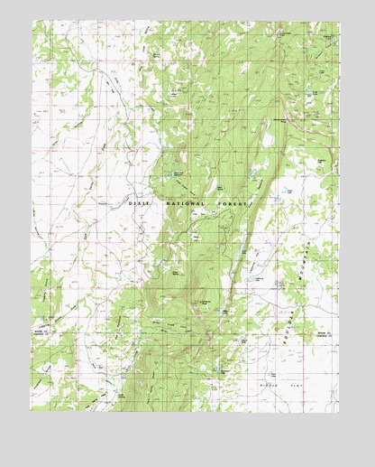
Government Point, UT USGS Topographic Map
Click on map above to begin viewing in our Map Viewer.

This topographic map contains these locations and features:
Feature Name Type Latitude Longitude GNIS ID View Map
Alkali LakeLakeN38.2262°W111.5689°1425076View Map
Aquarius Guard StationLocaleN38.1955°W111.5760°1425164View Map
Aquarius TrailTrailN38.2203°W111.5702°1425165View Map
Baker SpringSpringN38.1965°W111.5500°1425243View Map
Birch CreekStreamN38.1400°W111.6021°1425594View Map
Bullberry LakesLakeN38.2447°W111.5032°1437869View Map
Chuck LakeLakeN38.1481°W111.5400°1433093View Map
Cook LakeLakeN38.1768°W111.5400°1426835View Map
Cook PastureFlatN38.1841°W111.5399°1426836View Map
Dark ValleyValleyN38.2336°W111.5968°1440272View Map
Dark Valley DrawValleyN38.2158°W111.5916°1435387View Map
Giles HollowValleyN38.2369°W111.5999°1441321View Map
Government LakeLakeN38.2462°W111.5249°1428288View Map
Government PointCapeN38.2180°W111.5213°1428290View Map
Grass LakeLakeN38.1953°W111.5233°1428346View Map
Lava LakeLakeN38.2336°W111.5091°1435848View Map
Lava SpringSpringN38.1302°W111.5894°1429499View Map
Lightning FlatFlatN38.1739°W111.5338°1435859View Map
Lightning LakeLakeN38.1676°W111.5351°1429610View Map
Logging GroveWoodsN38.1644°W111.6238°1442865View Map
Logging Grove DrawValleyN38.1625°W111.6021°1442866View Map
Lone Pine FlatFlatN38.1878°W111.5552°1435890View Map
Lookout PeakSummitN38.1605°W111.5557°1429931View Map
Lost LakeLakeN38.2274°W111.5122°1429943View Map
Mill FieldAreaN38.2286°W111.5932°1435955View Map
Miller CreekStreamN38.1711°W111.6007°1430341View Map
Miller Creek CoveSlopeN38.1525°W111.5680°1435957View Map
Miller LakeLakeN38.1573°W111.5480°1430343View Map
Peterson GroveWoodsN38.1386°W111.6216°1444307View Map
Pine Creek CoveSlopeN38.1964°W111.5630°1436131View Map
Pine Creek ReservoirReservoirN38.2010°W111.5677°1431255View Map
Pine Creek Reservoir DamDamN38.2019°W111.5680°1434669View Map
Pinto KnollSummitN38.1361°W111.5355°1450466View Map
Pollywog Lake TrailTrailN38.1855°W111.5993°1431395View Map
Slope SpringSpringN38.1697°W111.5677°1436372View Map
Snow LakesLakeN38.1649°W111.5245°1432595View Map
Spruce SpringSpringN38.2389°W111.5749°1450511View Map
Station CreekStreamN38.1947°W111.6013°1432932View Map
Surveyors LakeLakeN38.1384°W111.5487°1455540View Map
The PotholesRangeN38.1522°W111.5888°1436169View Map
Torgerson LakeSwampN38.2045°W111.5111°1433601View Map
Twin LakesLakeN38.1372°W111.5283°1446786View Map
Twin LakesLakeN38.1380°W111.5275°1436533View Map
West LakeLakeN38.1393°W111.5304°1455691View Map

Note: Coordinates in the location and feature list above are referenced to NAD83 datum.


Copyright (C) 2008-2024 Ryan Niemi / Sunset Dynamics ... All Rights Reserved