TopoQuest Logo
Do you find TopoQuest useful?
Help keep TopoQuest running and adding new maps/features by donating!
Bitcoin:  19c7KJd3qBynnjoSw5npx9KScwjBe4ifkT
Litecoin:  LXs6TkuXGGXo1vDsWCkWVdjQX94eUKd6ui
Home View Maps Find Maps Find Places Resources & Links


Golddust, Tennessee Topographic Map

USGS Map Title: Golddust, TN
USGS Map MRC: 35089F7
DRG (GeoTIFF) Download: o35089f7.tif


Neighboring USGS Topographic Map Quads:


  Luxora, AR  
35089G8
 

  Rosa, AR  
35089G7
 

  Open Lake, TN  
35089G6
 

  Osceola, AR  
35089F8
 

  Golddust, TN  
35089F7
 

  Fort Pillow, TN  
35089F6
 

  Nodena, AR  
35089E8
 

  Gilt Edge, TN  
35089E7
 

  Covington, TN  
35089E6


Map MRC Location:

N36°
W90°
N36°
W89°
H8 H7 H6 H5 H4 H3 H2 H1
G8 G7 G6 G5 G4 G3 G2 G1
F8 F7 F6 F5 F4 F3 F2 F1
E8 E7 E6 E5 E4 E3 E2 E1
D8 D7 D6 D5 D4 D3 D2 D1
C8 C7 C6 C5 C4 C3 C2 C1
B8 B7 B6 B5 B4 B3 B2 B1
A8 A7 A6 A5 A4 A3 A2 A1
N35°
W90°
N35°
W89°

Golddust, TN USGS 1:24K Topographic Map Preview:
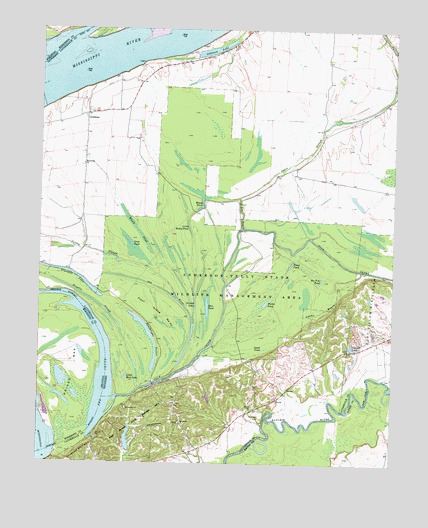
Golddust, TN USGS Topographic Map
Click on map above to begin viewing in our Map Viewer.

This topographic map contains these locations and features:
Feature Name Type Latitude Longitude GNIS ID View Map
Adams BayouStreamN35.6587°W89.7942°1275450View Map
Ash BayouStreamN35.6929°W89.8034°1275924View Map
Ashport Keyes Point RevetmentLeveeN35.7287°W89.8695°1311080View Map
Ashport TowheadIslandN35.7476°W89.8104°1644948View Map
Bates CemeteryCemeteryN35.6417°W89.7990°1276462View Map
Bee Tree PondLakeN35.6780°W89.7756°1276786View Map
Bethlehem ChurchChurchN35.7112°W89.8595°1277169View Map
Blue PondLakeN35.6717°W89.8153°1277771View Map
Broglin SloughLakeN35.6725°W89.8577°1278453View Map
Chickasaw Bluff Number OneCliffN35.6259°W89.8659°1314116View Map
Cold CreekStreamN35.6437°W89.8470°1280886View Map
Commissioner District 5CivilN35.6982°W89.8107°2464464View Map
Convict LakeLakeN35.6589°W89.7645°1281100View Map
Cotton SloughStreamN35.6723°W89.8259°1281367View Map
Driver BarBarN35.6526°W89.8651°48609View Map
Flour Island Number ThirtythreeIslandN35.6687°W89.8329°1314162View Map
Forked LakeLakeN35.6636°W89.8206°1284640View Map
Fort Pillow (historical)LocaleN35.6409°W89.8440°1318083View Map
Fort Pillow LandingLocaleN35.6426°W89.8495°1318084View Map
Fort Pillow School (historical)SchoolN35.6370°W89.8245°1318085View Map
Fort Pillow State Historic AreaParkN35.6367°W89.8401°1318086View Map
Fort Pillow State ParkParkN35.6362°W89.8423°1269584View Map
Gold Dust DikeLeveeN35.7287°W89.8745°1311090View Map
Gold Dust LandingLocaleN35.7265°W89.8748°1318089View Map
GolddustPopulated PlaceN35.7254°W89.8587°1285588View Map
Golddust BarBarN35.7340°W89.8618°1644949View Map
Golddust ChurchChurchN35.7062°W89.8570°1318090View Map
Golddust School (historical)SchoolN35.7267°W89.8487°1318091View Map
Goose PondLakeN35.6587°W89.7965°1285683View Map
Heathright PocketLakeN35.6646°W89.8375°1652477View Map
Johnson LakeLakeN35.7442°W89.8141°1289642View Map
Jones SloughStreamN35.7015°W89.8045°1289821View Map
Little Mud LakeLakeN35.6498°W89.8440°1291590View Map
Little Roney PondLakeN35.6931°W89.8222°1291654View Map
Lower Hatchie National Wildlife RefugeParkN35.6333°W89.7794°1320991View Map
Oak GrovePopulated PlaceN35.6334°W89.8215°1311107View Map
Oak Grove ChurchChurchN35.6367°W89.8245°1296094View Map
Old RiverStreamN35.6723°W89.8256°1296357View Map
Otter PondLakeN35.6866°W89.8415°1296522View Map
Roney PondLakeN35.7028°W89.8195°1300047View Map
Samuels CemeteryCemeteryN35.6387°W89.7967°1300651View Map
Sanders Airport (historical)AirportN35.7001°W89.8334°1301362View Map
The ChuteLakeN35.6690°W89.8586°1272379View Map
The ChuteStreamN35.6329°W89.8570°55508View Map
Trout PondLakeN35.6824°W89.7862°1272916View Map
Walker PondLakeN35.6714°W89.7949°1273639View Map
Whale PondLakeN35.6927°W89.8410°1274270View Map
Yankee BarBarN35.6584°W89.8431°1647460View Map
Yankee BarBarN35.6487°W89.8562°61958View Map

Note: Coordinates in the location and feature list above are referenced to NAD83 datum.


Copyright (C) 2008-2024 Ryan Niemi / Sunset Dynamics ... All Rights Reserved