TopoQuest Logo
Do you find TopoQuest useful?
Help keep TopoQuest running and adding new maps/features by donating!
Bitcoin:  19c7KJd3qBynnjoSw5npx9KScwjBe4ifkT
Litecoin:  LXs6TkuXGGXo1vDsWCkWVdjQX94eUKd6ui
Home View Maps Find Maps Find Places Resources & Links


Garfield Basin, Utah Topographic Map

USGS Map Title: Garfield Basin, UT
USGS Map MRC: 40110F4
DRG (GeoTIFF) Download: o40110f4.tif


Neighboring USGS Topographic Map Quads:


  Mount Lovenia, UT  
40110G5
 

  Mount Powell, UT  
40110G4
 

  Kings Peak, UT  
40110G3
 

  Oweep Creek, UT  
40110F5
 

  Garfield Basin, UT  
40110F4
 

  Mount Emmons, UT  
40110F3
 

  Kidney Lake, UT  
40110E5
 

  Lake Fork Mountain, UT  
40110E4
 

  Burnt Mill Spring, UT  
40110E3


Map MRC Location:

N41°
W111°
N41°
W110°
H8 H7 H6 H5 H4 H3 H2 H1
G8 G7 G6 G5 G4 G3 G2 G1
F8 F7 F6 F5 F4 F3 F2 F1
E8 E7 E6 E5 E4 E3 E2 E1
D8 D7 D6 D5 D4 D3 D2 D1
C8 C7 C6 C5 C4 C3 C2 C1
B8 B7 B6 B5 B4 B3 B2 B1
A8 A7 A6 A5 A4 A3 A2 A1
N40°
W111°
N40°
W110°

Garfield Basin, UT USGS 1:24K Topographic Map Preview:
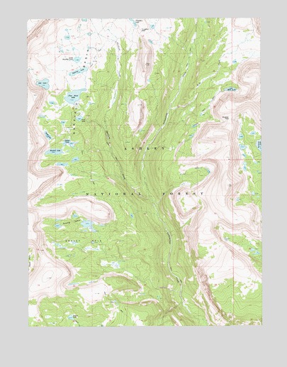
Garfield Basin, UT USGS Topographic Map
Click on map above to begin viewing in our Map Viewer.

This topographic map contains these locations and features:
Feature Name Type Latitude Longitude GNIS ID View Map
Bluebell LakeLakeN40.6961°W110.4863°1425834View Map
Bluebell PassGapN40.7088°W110.3918°1425836View Map
Doll LakeLakeN40.7236°W110.4919°1427445View Map
Drift LakeReservoirN40.7026°W110.4898°1427479View Map
Drift Lake DamDamN40.7016°W110.4874°1434840View Map
Farmers LakeLakeN40.6978°W110.3754°1441003View Map
Five Point Forest Service StationLocaleN40.7147°W110.4752°1455278View Map
Five Point LakeReservoirN40.7186°W110.4758°1427974View Map
Five Point Lake DamDamN40.7166°W110.4757°1434842View Map
Garfield BasinBasinN40.7319°W110.4668°1441276View Map
Garfield CreekStreamN40.6777°W110.4357°1441277View Map
Gem LakeLakeN40.7096°W110.4729°1428164View Map
High Uintas WildernessReserveN40.7410°W110.4774°2035156View Map
Little Superior LakeLakeN40.7334°W110.4740°1429803View Map
Milk CreekStreamN40.7133°W110.4232°1443391View Map
Milk LakeReservoirN40.7209°W110.3918°1430321View Map
Milk Lake DamDamN40.7206°W110.3953°1434845View Map
North Duchesne DivisionCivilN40.6482°W110.4427°1939398View Map
Spider LakeLakeN40.6997°W110.4782°1432791View Map
Superior LakeReservoirN40.7285°W110.4732°1433086View Map
Superior Lake DamDamN40.7283°W110.4724°1434849View Map
Swasey HoleBendN40.6594°W110.4704°1433114View Map
Swasey LakesLakeN40.6700°W110.4755°1433115View Map
Toquer LakeLakeN40.6287°W110.4781°1433600View Map
Tungsten LakeLakeN40.7481°W110.4438°1446759View Map
Tungsten PassGapN40.7455°W110.4385°1433696View Map

Note: Coordinates in the location and feature list above are referenced to NAD83 datum.


Copyright (C) 2008-2024 Ryan Niemi / Sunset Dynamics ... All Rights Reserved