TopoQuest Logo
Do you find TopoQuest useful?
Help keep TopoQuest running and adding new maps/features by donating!
Bitcoin:  19c7KJd3qBynnjoSw5npx9KScwjBe4ifkT
Litecoin:  LXs6TkuXGGXo1vDsWCkWVdjQX94eUKd6ui
Home View Maps Find Maps Find Places Resources & Links


Frisco, Colorado Topographic Map

USGS Map Title: Frisco, CO
USGS Map MRC: 39106E1
DRG (GeoTIFF) Download: o39106e1.tif


Neighboring USGS Topographic Map Quads:


  Willow Lakes, CO  
39106F2
 

  Dillon, CO  
39106F1
 

  Loveland Pass, CO  
39105F8
 

  Vail Pass, CO  
39106E2
 

  Frisco, CO  
39106E1
 

  Keystone, CO  
39105E8
 

  Copper Mountain, CO  
39106D2
 

  Breckenridge, CO  
39106D1
 

  Boreas Pass, CO  
39105D8


Map MRC Location:

N40°
W107°
N40°
W106°
H8 H7 H6 H5 H4 H3 H2 H1
G8 G7 G6 G5 G4 G3 G2 G1
F8 F7 F6 F5 F4 F3 F2 F1
E8 E7 E6 E5 E4 E3 E2 E1
D8 D7 D6 D5 D4 D3 D2 D1
C8 C7 C6 C5 C4 C3 C2 C1
B8 B7 B6 B5 B4 B3 B2 B1
A8 A7 A6 A5 A4 A3 A2 A1
N39°
W107°
N39°
W106°

Frisco, CO USGS 1:24K Topographic Map Preview:
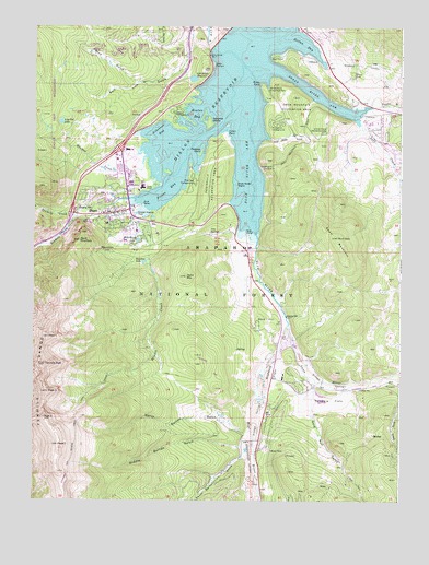
Frisco, CO USGS Topographic Map
Click on map above to begin viewing in our Map Viewer.

This topographic map contains these locations and features:
Feature Name Type Latitude Longitude GNIS ID View Map
Bills Ranch LakeLakeN39.5686°W106.0899°176220View Map
Blue River ArmBayN39.5869°W106.0528°176228View Map
Blue River Inlet Fishermans ParkingLocaleN39.5689°W106.0528°197265View Map
Braddock FlatsFlatN39.5342°W106.0434°176210View Map
Breckenridge Airport (historical)AirportN39.5069°W106.0497°176209View Map
Breckenridge DivisionCivilN39.5111°W106.0410°1935411View Map
Colorado State Patrol Frisco PostBuildingN39.5724°W106.0827°2735565View Map
Como ClaimsMineN39.5030°W106.0345°1735326View Map
Crown PointCapeN39.5972°W106.0595°176241View Map
Delaware FlatsFlatN39.5267°W106.0259°176211View Map
Dillon BayBayN39.6097°W106.0603°176243View Map
Dillon CemeteryCemeteryN39.6125°W106.0170°176248View Map
Dillon DamDamN39.6217°W106.0656°199766View Map
Dillon OverlookLocaleN39.6144°W106.0645°176233View Map
Dillon ReservoirReservoirN39.6016°W106.0580°202344View Map
Fishhook IslandIslandN39.5919°W106.0681°176242View Map
Flight for Life Colorado 2 Medical TransportBuildingN39.5692°W106.0789°2716951View Map
FriscoPopulated PlaceN39.5744°W106.0975°176218View Map
Frisco BayBayN39.5814°W106.0806°176213View Map
Frisco Bay Fishermans ParkingLocaleN39.5814°W106.0922°197264View Map
Frisco CemeteryCemeteryN39.5773°W106.0917°2734544View Map
Frisco MarinaLocaleN39.5880°W106.0689°176226View Map
Frisco MineMineN39.5772°W106.0986°1735414View Map
Frisco Police DepartmentBuildingN39.5757°W106.1024°2757286View Map
Frisco Post OfficePost OfficeN39.5758°W106.1038°2734621View Map
Giberson BayBayN39.5980°W106.0836°176224View Map
Giberson Bay Fishermans ParkingLocaleN39.6008°W106.0806°197275View Map
Gold Cord Tunnel MineMineN39.5105°W106.0003°1694385View Map
Gold HillPopulated PlaceN39.5453°W106.0484°176217View Map
Gold Pan CampgroundLocaleN39.5747°W106.0756°197263View Map
Gold Run GulchValleyN39.5243°W106.0300°176202View Map
Gold Run Gulch Claims MineMineN39.5203°W106.0186°1684201View Map
Heaton BayBayN39.6025°W106.0703°176238View Map
Heaton CampgroundLocaleN39.6022°W106.0775°176237View Map
Horseshoe GulchValleyN39.5337°W106.0006°182371View Map
Iron SpringsSpringN39.5705°W106.0647°176215View Map
King Solomon MineMineN39.5669°W106.1217°1684202View Map
KYSL-FM (Frisco)TowerN39.5561°W106.1153°204131View Map
Lake Dillon Fire - Rescue Station 2BuildingN39.5743°W106.0924°2667152View Map
Lake HillSummitN39.6136°W106.0675°196423View Map
Lily Pad LakeLakeN39.5997°W106.1161°176225View Map
Lily Pad Lake TrailTrailN39.6092°W106.1122°197276View Map
MasontownPopulated PlaceN39.5664°W106.1003°176221View Map
Meadow CreekStreamN39.5925°W106.0731°176190View Map
Middle Barton GulchValleyN39.5141°W106.0539°176207View Map
Miners CreekStreamN39.5858°W106.0767°176232View Map
Miners Creek TrailTrailN39.5072°W106.1131°202367View Map
Naperville Tunnel MineMineN39.5036°W106.0317°1684203View Map
North Barton GulchValleyN39.5175°W106.0530°176208View Map
North Tenmile CreekStreamN39.5747°W106.1109°176189View Map
Old Dillon DamDamN39.6117°W106.0722°201246View Map
Old Dillon ReservoirReservoirN39.6112°W106.0712°176236View Map
Ophir MountainSummitN39.5592°W106.0731°176216View Map
Peak FiveSummitN39.5147°W106.1167°176206View Map
Peak FourSummitN39.5216°W106.1214°176205View Map
Peak OneSummitN39.5430°W106.1200°176223View Map
Peak One CampgroundLocaleN39.5836°W106.0706°176230View Map
Peak ThreeSummitN39.5283°W106.1200°176204View Map
Peninsula Recreation AreaLocaleN39.5855°W106.0636°176229View Map
Pine Cove CampgroundLocaleN39.5883°W106.0686°197272View Map
Prospector CampgroundLocaleN39.5997°W106.0425°176240View Map
Rainbow LakeLakeN39.5628°W106.0876°176222View Map
Red White and Blue Fire District Station 4BuildingN39.5304°W106.0457°2666836View Map
Royal MountainSummitN39.5686°W106.1095°176219View Map
Ryan GulchValleyN39.6100°W106.0899°176231View Map
Saint Anthony Summit Medical CenterHospitalN39.5694°W106.0778°2695636View Map
Salt Lick GulchValleyN39.6233°W106.0715°176188View Map
Sapphire Point OverlookLocaleN39.5886°W106.0442°176227View Map
Sentinel IslandIslandN39.5997°W106.0659°176239View Map
Sentinel Island CampgroundLocaleN39.5997°W106.0653°197274View Map
Silver Dollar IslandIslandN39.5833°W106.0564°176214View Map
Snake RiverStreamN39.6153°W106.0542°176197View Map
Snake River ArmBayN39.6067°W106.0286°176247View Map
Snake River Fishermans ParkingLocaleN39.6042°W106.0145°197273View Map
Soda CreekStreamN39.5994°W106.0142°176198View Map
Soda GulchValleyN39.5960°W106.0466°176244View Map
South Barton GulchValleyN39.5118°W106.0531°176201View Map
Squaw CreekStreamN39.5833°W106.0822°189450View Map
Summit County Ambulance ServiceBuildingN39.5688°W106.0830°2716994View Map
Summit Medical Center HeliportAirportN39.5811°W106.0928°204410View Map
Swan MountainSummitN39.5694°W106.0220°176212View Map
Swan Mountain Recreation AreaLocaleN39.6042°W106.0370°176246View Map
Swan RiverStreamN39.5464°W106.0384°176199View Map
Tenmile CreekStreamN39.6153°W106.0542°176191View Map
Tenmile PeakSummitN39.5358°W106.1211°176203View Map
Town of DillonCivilN39.6210°W106.0386°2412431View Map
Town of FriscoCivilN39.5794°W106.0919°2412661View Map
Williams-Hamm Diversion DitchCanalN39.5867°W106.0670°189444View Map
Windy PointCapeN39.6103°W106.0481°176235View Map
Windy Point Fisherman ParkParkN39.6072°W106.0453°176234View Map

Note: Coordinates in the location and feature list above are referenced to NAD83 datum.


Copyright (C) 2008-2024 Ryan Niemi / Sunset Dynamics ... All Rights Reserved