TopoQuest Logo
Do you find TopoQuest useful?
Help keep TopoQuest running and adding new maps/features by donating!
Bitcoin:  19c7KJd3qBynnjoSw5npx9KScwjBe4ifkT
Litecoin:  LXs6TkuXGGXo1vDsWCkWVdjQX94eUKd6ui
Home View Maps Find Maps Find Places Resources & Links


Fox Island, Washington Topographic Map

USGS Map Title: Fox Island, WA
USGS Map MRC: 47122C6
DRG (GeoTIFF) Download: o47122c6.tif


Neighboring USGS Topographic Map Quads:


  Belfair, WA  
47122D7
 

  Burley, WA  
47122D6
 

  Olalla, WA  
47122D5
 

  Vaughn, WA  
47122C7
 

  Fox Island, WA  
47122C6
 

  Gig Harbor, WA  
47122C5
 

  Longbranch, WA  
47122B7
 

  McNeil Island, WA  
47122B6
 

  Steilacoom, WA  
47122B5


Map MRC Location:

N48°
W123°
N48°
W122°
H8 H7 H6 H5 H4 H3 H2 H1
G8 G7 G6 G5 G4 G3 G2 G1
F8 F7 F6 F5 F4 F3 F2 F1
E8 E7 E6 E5 E4 E3 E2 E1
D8 D7 D6 D5 D4 D3 D2 D1
C8 C7 C6 C5 C4 C3 C2 C1
B8 B7 B6 B5 B4 B3 B2 B1
A8 A7 A6 A5 A4 A3 A2 A1
N47°
W123°
N47°
W122°

Fox Island, WA USGS 1:24K Topographic Map Preview:
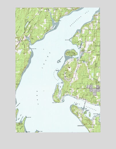
Fox Island, WA USGS Topographic Map
Click on map above to begin viewing in our Map Viewer.

This topographic map contains these locations and features:
Feature Name Type Latitude Longitude GNIS ID View Map
Allen PointCapeN47.3423°W122.6704°1503001View Map
ArlettaPopulated PlaceN47.2901°W122.6676°1511970View Map
Artondale Census Designated PlaceCensusN47.3020°W122.6399°2407769View Map
Camp ColmanLocaleN47.2998°W122.6796°1503734View Map
Camp SeymourLocaleN47.3437°W122.7282°1503749View Map
Carr InletBayN47.2557°W122.6859°1503821View Map
Castlenook (historical)Populated PlaceN47.2657°W122.6357°1514791View Map
Cutts IslandIslandN47.3209°W122.6871°1533033View Map
Cutts Island State ParkParkN47.3209°W122.6876°1511746View Map
Delano BeachLocaleN47.2504°W122.7385°1504431View Map
ElginLocaleN47.3693°W122.7004°1514660View Map
Ford HillSummitN47.2973°W122.6382°1512218View Map
Forest BeachPopulated PlaceN47.2940°W122.6885°1512220View Map
Fox IslandPopulated PlaceN47.2607°W122.6371°1530887View Map
Fox IslandPopulated PlaceN47.2515°W122.6290°1867612View Map
Fox Island CemeteryCemeteryN47.2502°W122.6362°1505015View Map
Fox Island Post OfficePost OfficeN47.2574°W122.6379°2462220View Map
Fox Island Yacht ClubLocaleN47.2659°W122.6465°2610305View Map
Gig Harbor AcademySchoolN47.2855°W122.6300°2606399View Map
Gig Harbor Golf ClubLocaleN47.3057°W122.6284°2608397View Map
Glen CoveBayN47.3430°W122.7319°1505148View Map
GlencovePopulated PlaceN47.3459°W122.7371°1510992View Map
Green PointCapeN47.2809°W122.6937°1505273View Map
Hale PassageChannelN47.2709°W122.6296°1505342View Map
Henderson BayBayN47.3664°W122.6571°1505463View Map
Horsehead BayBayN47.2955°W122.6846°1505614View Map
Island BridgeBridgeN47.2770°W122.6493°1505754View Map
Ketners PointCapeN47.2673°W122.6290°1505958View Map
Key CenterPopulated PlaceN47.3407°W122.7454°1505962View Map
Key Center LibraryBuildingN47.3383°W122.7466°2610154View Map
Key Peninsula-Anderson Island DivisionCivilN47.2541°W122.7401°1939545View Map
Kopachuck Middle SchoolSchoolN47.3055°W122.6782°2462386View Map
Kopachuck State ParkParkN47.3165°W122.6785°1506023View Map
Lake BayPopulated PlaceN47.2518°W122.7385°1514788View Map
Lake MinterwoodLakeN47.3581°W122.7343°1511778View Map
Lay InletBayN47.3360°W122.6552°1506115View Map
Mayo CoveBayN47.2639°W122.7464°1531008View Map
McCormick CreekStreamN47.3720°W122.6251°1506541View Map
Meyer CreekStreamN47.3401°W122.6505°2765166View Map
MinterPopulated PlaceN47.3620°W122.6876°1513167View Map
Minter Community CenterBuildingN47.3743°W122.6932°1506731View Map
Minter CreekStreamN47.3698°W122.6996°1531024View Map
Minter Creek Elementary SchoolSchoolN47.3725°W122.6928°2462418View Map
Nearns PointCapeN47.2776°W122.6662°1506936View Map
Olufson DamDamN47.3115°W122.6612°1532559View Map
Peninsula Mobile ParkPopulated PlaceN47.3402°W122.6252°2607257View Map
Penrose PointCapeN47.2651°W122.7371°1507370View Map
Penrose Point State ParkParkN47.2587°W122.7440°1507371View Map
Pierce County Fire District 5 / Gig Harbor Fire and Medic One Station 54 ArlettaBuildingN47.2988°W122.6703°2619612View Map
Pierce County Fire District 5 / Gig Harbor Fire and Medic One Station 55 RosedaleBuildingN47.3291°W122.6413°2619613View Map
Pierce County Fire Protection District 16 Key Peninsula Fire Department Station 2BuildingN47.3389°W122.7463°2619778View Map
Raft IslandIslandN47.3293°W122.6690°1507689View Map
Raft Island Census Designated PlaceCensusN47.3290°W122.6688°2585028View Map
Reed DamDamN47.3465°W122.6562°1532658View Map
Roland LakeReservoirN47.3581°W122.7342°1532088View Map
Rolland Lake DamDamN47.3615°W122.7312°1532087View Map
RosedalePopulated PlaceN47.3315°W122.6524°1512622View Map
Rosedale Census Designated PlaceCensusN47.3453°W122.6372°2585032View Map
Rosedale Reformed Bible ChurchChurchN47.3302°W122.6544°2609521View Map
Scott PointCapeN47.2990°W122.6874°1514652View Map
Shaws CoveCapeN47.2834°W122.6807°1508262View Map
Shorewood BeachLocaleN47.2701°W122.6482°1508321View Map
South HeadCliffN47.2507°W122.7193°1508550View Map
Sunny BayLocaleN47.2779°W122.6299°1508823View Map
Sunrise BeachPopulated PlaceN47.3234°W122.6979°1511840View Map
Sunshine BeachPopulated PlaceN47.3543°W122.7318°1511839View Map
Sylvia LakeReservoirN47.3205°W122.6502°1532086View Map
Sylvia Lake DamDamN47.3215°W122.6529°1532085View Map
Tanglewood IslandIslandN47.2676°W122.6424°1533060View Map
Thompson SplitBarN47.3326°W122.7285°1508999View Map
Towhead IslandIslandN47.2737°W122.6504°1509063View Map
Vaughn Post OfficePost OfficeN47.3410°W122.7470°2607038View Map
Voyager Elementary SchoolSchoolN47.3092°W122.6782°2606526View Map
WarrenPopulated PlaceN47.2820°W122.6524°1511411View Map

Note: Coordinates in the location and feature list above are referenced to NAD83 datum.


Copyright (C) 2008-2024 Ryan Niemi / Sunset Dynamics ... All Rights Reserved