TopoQuest Logo
Do you find TopoQuest useful?
Help keep TopoQuest running and adding new maps/features by donating!
Bitcoin:  19c7KJd3qBynnjoSw5npx9KScwjBe4ifkT
Litecoin:  LXs6TkuXGGXo1vDsWCkWVdjQX94eUKd6ui
Home View Maps Find Maps Find Places Resources & Links


Fowling Creek, Maryland Topographic Map

USGS Map Title: Fowling Creek, MD
USGS Map MRC: 38075G8
DRG (GeoTIFF) Download: o38075g8.tif


Neighboring USGS Topographic Map Quads:


  Wye Mills, MD  
38076H1
 

  Ridgely, MD  
38075H8
 

  Denton, MD  
38075H7
 

  Easton, MD  
38076G1
 

  Fowling Creek, MD  
38075G8
 

  Hobbs, MD  
38075G7
 

  Trappe, MD  
38076F1
 

  Preston, MD  
38075F8
 

  Federalsburg, MD  
38075F7


Map MRC Location:

N39°
W76°
N39°
W75°
H8 H7 H6 H5 H4 H3 H2 H1
G8 G7 G6 G5 G4 G3 G2 G1
F8 F7 F6 F5 F4 F3 F2 F1
E8 E7 E6 E5 E4 E3 E2 E1
D8 D7 D6 D5 D4 D3 D2 D1
C8 C7 C6 C5 C4 C3 C2 C1
B8 B7 B6 B5 B4 B3 B2 B1
A8 A7 A6 A5 A4 A3 A2 A1
N38°
W76°
N38°
W75°

Fowling Creek, MD USGS 1:24K Topographic Map Preview:
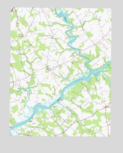
Fowling Creek, MD USGS Topographic Map
Click on map above to begin viewing in our Map Viewer.

This topographic map contains these locations and features:
Feature Name Type Latitude Longitude GNIS ID View Map
Beaverdam BranchStreamN38.7971°W75.9766°583111View Map
Bell Chapel African Methodist Episcopal ChurchChurchN38.8601°W75.9130°595718View Map
Bell Chapel CemeteryCemeteryN38.8601°W75.9132°595719View Map
Bell CreekStreamN38.7896°W75.9333°583143View Map
Berry RunStreamN38.7973°W75.9280°583168View Map
Blairtown (historical)Populated PlaceN38.7562°W75.9002°595721View Map
Chancellors BranchStreamN38.7937°W75.9930°592683View Map
Chapel WoodsPopulated PlaceN38.8632°W75.9747°592686View Map
Cordova Baptist ChurchChurchN38.8722°W75.9937°2503225View Map
Cordova Census Designated PlaceCensusN38.8680°W75.9989°2389360View Map
Cordova Post OfficePost OfficeN38.8748°W75.9955°595459View Map
Cordova Volunteer Fire Department Station 50BuildingN38.8743°W75.9959°2131764View Map
Country Life AcresPopulated PlaceN38.8709°W75.9280°595755View Map
Cowards PointCapeN38.8571°W75.9233°583941View Map
Crowberry CreekStreamN38.7768°W75.9483°583984View Map
Dawson BranchStreamN38.8029°W75.9124°584030View Map
Deep BranchStreamN38.8548°W75.9216°584047View Map
Dileo FieldAirportN38.8364°W75.9074°2443781View Map
Doans LandingLocaleN38.8559°W75.9219°595767View Map
Dover BridgeBridgeN38.7571°W75.9972°584142View Map
Dover Ferry (historical)CrossingN38.7571°W75.9972°592721View Map
Downes LandingLocaleN38.8226°W75.8783°595769View Map
East Providence LandingLocaleN38.7682°W75.9716°595773View Map
Ewing AirportAirportN38.8074°W75.9917°595273View Map
Fairview CemeteryCemeteryN38.8569°W75.9757°592737View Map
Fairview ChurchChurchN38.8573°W75.9752°584330View Map
Forest GardensPopulated PlaceN38.8354°W75.9822°592747View Map
Fowling CreekStreamN38.8137°W75.8852°584471View Map
Ganey WharfLocaleN38.8046°W75.9097°584552View Map
Gilpin PointCapeN38.8096°W75.8983°584595View Map
GriffinPopulated PlaceN38.8615°W75.9138°590388View Map
HarmonyPopulated PlaceN38.7790°W75.8805°584869View Map
Harmony Community ParkParkN38.7798°W75.8780°595799View Map
Harmony United Methodist ChurchChurchN38.7787°W75.8810°595800View Map
Harris Methodist Chapel (historical)ChurchN38.8401°W75.8960°595801View Map
High BanksPopulated PlaceN38.7976°W75.9244°592772View Map
Hog CreekStreamN38.7829°W75.9405°584992View Map
Hopeland AcresPopulated PlaceN38.7604°W75.9280°595816View Map
Jadwins CreekStreamN38.8359°W75.9244°592790View Map
Kellum FarmLocaleN38.8042°W75.9558°2726192View Map
Kings CreekStreamN38.7773°W75.9710°585317View Map
Kings Creek CemeteryCemeteryN38.8172°W75.9527°592796View Map
Kings Creek ChurchChurchN38.8168°W75.9527°592797View Map
Kingston LandingPopulated PlaceN38.7818°W75.9652°590605View Map
Kitty Corner ParkPopulated PlaceN38.8265°W75.9635°592799View Map
Kittys CornerPopulated PlaceN38.8462°W75.9838°588685View Map
LewistownPopulated PlaceN38.8451°W75.9477°590662View Map
MatthewsPopulated PlaceN38.8162°W75.9527°585737View Map
McCarty WharfLocaleN38.7787°W75.9463°585753View Map
Meadow View FarmsLocaleN38.8615°W75.9508°592819View Map
Millers LandingLocaleN38.8673°W75.9288°595837View Map
Mitchell RunStreamN38.7609°W75.9808°585913View Map
Mount Zion CemeteryCemeteryN38.7812°W75.8811°595842View Map
Mount Zion Pentecostal Holiness ChurchChurchN38.7809°W75.8783°595845View Map
New HopePopulated PlaceN38.8007°W75.9055°595846View Map
NewtonPopulated PlaceN38.7648°W75.9316°590882View Map
Picture Hill LandingLocaleN38.7737°W75.9635°595859View Map
ProvidencePopulated PlaceN38.7704°W75.9658°591077View Map
Providence LandingPopulated PlaceN38.7637°W75.9758°591080View Map
Robins CreekStreamN38.8198°W75.8802°586853View Map
Ross Farm WoodsPopulated PlaceN38.8251°W75.9169°592898View Map
Saint Paul Methodist Episcopal ChurchChurchN38.8723°W75.9947°592920View Map
School Number 10 (historical)SchoolN38.7665°W75.9302°595894View Map
School Number 14 (historical)SchoolN38.8298°W75.8813°595895View Map
School Number 8 (historical)SchoolN38.7782°W75.8810°595891View Map
Scull Farm Pond DamDamN38.8268°W75.8947°594527View Map
Smithson ChapelChurchN38.7654°W75.9313°595900View Map
Smithson Chapel CemeteryCemeteryN38.7656°W75.9313°595899View Map
TanyardPopulated PlaceN38.7507°W75.9766°591392View Map
Todd WharfLocaleN38.8134°W75.8830°587817View Map
Tuckahoe BridgeBridgeN38.8312°W75.9138°595916View Map
Tuckahoe CreekStreamN38.8148°W75.8972°598183View Map
Tuckahoe NeckCapeN38.8551°W75.8888°587897View Map
Tuckahoe SpringsPopulated PlaceN38.8334°W75.9052°595921View Map
Turkey CreekStreamN38.8009°W75.9244°592977View Map
Union Grove CemeteryCemeteryN38.7607°W75.8782°595926View Map
Wings LandingPopulated PlaceN38.7840°W75.9377°591577View Map

Note: Coordinates in the location and feature list above are referenced to NAD83 datum.


Copyright (C) 2008-2024 Ryan Niemi / Sunset Dynamics ... All Rights Reserved