TopoQuest Logo
Do you find TopoQuest useful?
Help keep TopoQuest running and adding new maps/features by donating!
Bitcoin:  19c7KJd3qBynnjoSw5npx9KScwjBe4ifkT
Litecoin:  LXs6TkuXGGXo1vDsWCkWVdjQX94eUKd6ui
Home View Maps Find Maps Find Places Resources & Links


Ewing, Virginia Topographic Map

USGS Map Title: Ewing, VA
USGS Map MRC: 36083F4
DRG (GeoTIFF) Download: o36083f4.tif


Neighboring USGS Topographic Map Quads:


  Balkan, KY  
36083G5
 

  Wallins Creek, KY  
36083G4
 

  Harlan, KY  
36083G3
 

  Varilla, KY  
36083F5
 

  Ewing, VA  
36083F4
 

  Rose Hill, VA  
36083F3
 

  Wheeler, VA  
36083E5
 

  Coleman Gap, TN  
36083E4
 

  Back Valley, TN  
36083E3


Map MRC Location:

N37°
W84°
N37°
W83°
H8 H7 H6 H5 H4 H3 H2 H1
G8 G7 G6 G5 G4 G3 G2 G1
F8 F7 F6 F5 F4 F3 F2 F1
E8 E7 E6 E5 E4 E3 E2 E1
D8 D7 D6 D5 D4 D3 D2 D1
C8 C7 C6 C5 C4 C3 C2 C1
B8 B7 B6 B5 B4 B3 B2 B1
A8 A7 A6 A5 A4 A3 A2 A1
N36°
W84°
N36°
W83°

Ewing, VA USGS 1:24K Topographic Map Preview:
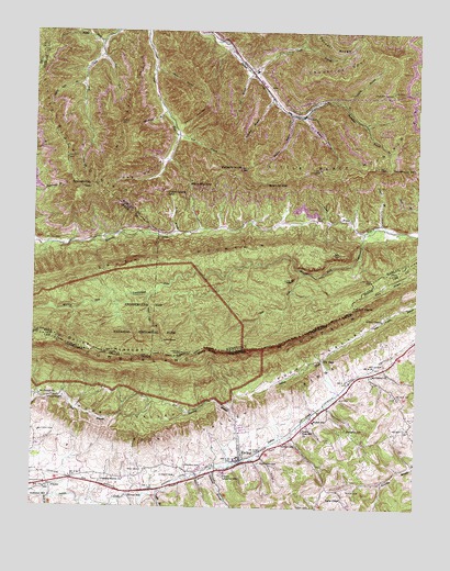
Ewing, VA USGS Topographic Map
Click on map above to begin viewing in our Map Viewer.

This topographic map contains these locations and features:
Feature Name Type Latitude Longitude GNIS ID View Map
AlvaPopulated PlaceN36.7351°W83.4244°485915View Map
Alva DivisionCivilN36.7227°W83.4146°1936852View Map
Alva Post Office (historical)Post OfficeN36.7348°W83.4242°2565525View Map
Alva Railroad Station (historical)LocaleN36.7320°W83.4220°2565526View Map
Arthur ChapelChurchN36.6743°W83.3863°1462561View Map
Arthur Chapel CemeteryCemeteryN36.6755°W83.3852°2774749View Map
Avondale Post Office (historical)Post OfficeN36.6996°W83.3974°2565529View Map
Avondale School (historical)SchoolN36.7006°W83.3977°2565530View Map
Bailes MeadowsFlatN36.6670°W83.4774°486205View Map
Bailes MeadowsFlatN36.6662°W83.4782°1462676View Map
Ball CemeteryCemeteryN36.6346°W83.4641°1462724View Map
Beartree BranchStreamN36.7281°W83.4160°486588View Map
Beartree GapGapN36.7106°W83.4241°486590View Map
Black Mountain GapGapN36.7101°W83.4496°487380View Map
Black Star Coal CampLocaleN36.7323°W83.4184°2565551View Map
Black Star Elementary School (historical)SchoolN36.7397°W83.4281°2565552View Map
Brittain CemeteryCemeteryN36.6442°W83.4977°1463833View Map
Brooks CemeteryCemeteryN36.6306°W83.4955°1463887View Map
Brooks CemeteryCemeteryN36.6359°W83.4495°1463888View Map
Brownies Creek School (historical)SchoolN36.6979°W83.4412°2565562View Map
Brownies RidgeRidgeN36.7168°W83.4878°2565563View Map
Butterfly KnobSummitN36.7143°W83.4330°488521View Map
CaylorPopulated PlaceN36.6306°W83.4944°1494196View Map
Cedar HollowValleyN36.7248°W83.4537°489223View Map
Chances BranchStreamN36.6354°W83.4407°1464726View Map
Chattels Station ChurchChurchN36.6323°W83.4696°1464759View Map
Chuncklick Look Out TowerTowerN36.7341°W83.3831°2565664View Map
Chunklick BranchStreamN36.7315°W83.3991°489506View Map
Chunklick SpurRidgeN36.7418°W83.3994°489507View Map
Cowan MillPopulated PlaceN36.6287°W83.4669°1494204View Map
Cy BranchStreamN36.7393°W83.4294°490516View Map
District 1CivilN36.6365°W83.4375°1927182View Map
Edds CemeteryCemeteryN36.6298°W83.3966°1466170View Map
Ely CemeteryCemeteryN36.6537°W83.4002°1466272View Map
Ely GapGapN36.6643°W83.4052°1466274View Map
Evergreen SchoolSchoolN36.6456°W83.3977°1466371View Map
EwingPopulated PlaceN36.6368°W83.4316°1466374View Map
Ewing Census Designated PlaceCensusN36.6381°W83.4291°2389055View Map
Ewing Elementary SchoolSchoolN36.6342°W83.4368°1465301View Map
Ewing Post OfficePost OfficeN36.6365°W83.4324°2766361View Map
Fulkerson Post Office (historical)Post OfficeN36.6999°W83.3867°2565624View Map
Gap HollowValleyN36.7228°W83.4536°492683View Map
Gibson CemeteryCemeteryN36.6412°W83.4185°1467064View Map
Green BranchStreamN36.7398°W83.4613°493261View Map
Indian Grave GapGapN36.7084°W83.4566°494954View Map
Ingles ChapelChurchN36.6273°W83.3982°1468502View Map
Kesterson MillPopulated PlaceN36.6273°W83.4944°1494241View Map
Kincaid CemeteryCemeteryN36.6332°W83.4528°1468998View Map
Laurel BranchStreamN36.6998°W83.3869°496016View Map
Lee BranchStreamN36.7276°W83.4130°496152View Map
Left Fork Martins Fork Cumberland RiverStreamN36.6870°W83.4121°496240View Map
Left Fork Mill CreekStreamN36.7437°W83.4782°496242View Map
Lick BranchStreamN36.7231°W83.4532°496450View Map
Lick BranchStreamN36.6281°W83.4591°1469392View Map
Littlefield BranchStreamN36.7329°W83.4224°496905View Map
Long Ridge Church (historical)ChurchN36.6437°W83.3755°1496547View Map
Lovely BranchStreamN36.6983°W83.4461°2565743View Map
Lower Rose Hill ChurchChurchN36.6454°W83.4116°1469919View Map
McLin CemeteryCemeteryN36.6629°W83.3852°1470276View Map
McLin NotchGapN36.6781°W83.3952°497924View Map
Meek BranchStreamN36.6276°W83.4960°1470338View Map
Mill SpurRidgeN36.7262°W83.4721°498299View Map
Moore BranchStreamN36.6970°W83.4541°498536View Map
Mount Carmel ChurchChurchN36.6543°W83.4971°1470839View Map
Mount Carmel ChurchChurchN36.6595°W83.3894°1470840View Map
Old Field BranchStreamN36.7284°W83.4571°499823View Map
Poplar Lick BranchStreamN36.7370°W83.4844°501121View Map
Richmond CemeteryCemeteryN36.6367°W83.4257°1473196View Map
Right Fork Mill CreekStreamN36.7473°W83.4782°501908View Map
Roaring BranchStreamN36.6365°W83.4352°1473300View Map
Rockhouse BranchStreamN36.7315°W83.3991°502181View Map
Rockhouse GapGapN36.7145°W83.3835°502207View Map
Rose Hill Census Designated PlaceCensusN36.6670°W83.3753°2389775View Map
Rose Hill District (historical)CivilN36.6334°W83.4480°1927477View Map
Rough BranchStreamN36.6976°W83.3921°502377View Map
Rowland CemeteryCemeteryN36.6538°W83.4898°1473607View Map
Saylor Post Office (historical)Post OfficeN36.6979°W83.4415°2565805View Map
Spanish Oak GapGapN36.7095°W83.4816°504018View Map
Thomas Walker Fire Department Station 1BuildingN36.6460°W83.4091°2768994View Map
Thomas Walker High SchoolSchoolN36.6476°W83.4082°1476241View Map
Toms BranchStreamN36.7401°W83.4305°505345View Map
Upper Martins Fork School (historical)SchoolN36.6970°W83.3928°2565845View Map
White RocksSummitN36.6670°W83.4430°506641View Map
Wilson CemeteryCemeteryN36.6951°W83.4963°506894View Map
Yeary CemeteryCemeteryN36.6254°W83.4085°1474331View Map

Note: Coordinates in the location and feature list above are referenced to NAD83 datum.


Copyright (C) 2008-2024 Ryan Niemi / Sunset Dynamics ... All Rights Reserved