TopoQuest Logo
Do you find TopoQuest useful?
Help keep TopoQuest running and adding new maps/features by donating!
Bitcoin:  19c7KJd3qBynnjoSw5npx9KScwjBe4ifkT
Litecoin:  LXs6TkuXGGXo1vDsWCkWVdjQX94eUKd6ui
Home View Maps Find Maps Find Places Resources & Links


Essex, North Carolina Topographic Map

USGS Map Title: Essex, NC
USGS Map MRC: 36077B8
DRG (GeoTIFF) Download: o36077b8.tif


Neighboring USGS Topographic Map Quads:


  Inez, NC  
36078C1
 

  Hollister, NC  
36077C8
 

  Aurelian Springs, NC  
36077C7
 

  Centerville, NC  
36078B1
 

  Essex, NC  
36077B8
 

  Ringwood, NC  
36077B7
 

  Castalia, NC  
36078A1
 

  Red Oak, NC  
36077A8
 

  Drake, NC  
36077A7


Map MRC Location:

N37°
W78°
N37°
W77°
H8 H7 H6 H5 H4 H3 H2 H1
G8 G7 G6 G5 G4 G3 G2 G1
F8 F7 F6 F5 F4 F3 F2 F1
E8 E7 E6 E5 E4 E3 E2 E1
D8 D7 D6 D5 D4 D3 D2 D1
C8 C7 C6 C5 C4 C3 C2 C1
B8 B7 B6 B5 B4 B3 B2 B1
A8 A7 A6 A5 A4 A3 A2 A1
N36°
W78°
N36°
W77°

Essex, NC USGS 1:24K Topographic Map Preview:
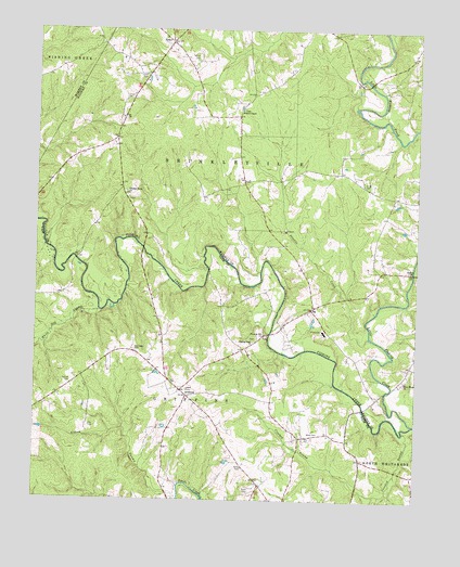
Essex, NC USGS Topographic Map
Click on map above to begin viewing in our Map Viewer.

This topographic map contains these locations and features:
Feature Name Type Latitude Longitude GNIS ID View Map
Avent CemeteryCemeteryN36.1546°W77.9500°980381View Map
AventonPopulated PlaceN36.1529°W77.9497°1018879View Map
Aventon Post OfficePost OfficeN36.1529°W77.9497°1952530View Map
Aventon School (historical)SchoolN36.1424°W77.9567°1951072View Map
Aventon School (historical)SchoolN36.1627°W77.9372°1951074View Map
Battles BridgeBridgeN36.1499°W77.8914°1006913View Map
Bluff Loop TrailTrailN36.2429°W77.8930°1853981View Map
Crooked SwampStreamN36.1438°W77.8789°983473View Map
Davis BridgeBridgeN36.1693°W77.9228°1006914View Map
Doziers LakeReservoirN36.1452°W77.9564°1000180View Map
Doziers Lake DamDamN36.1452°W77.9564°1000179View Map
EssexPopulated PlaceN36.2468°W77.9567°984837View Map
Fishing Creek ChurchChurchN36.1674°W77.9286°985120View Map
Fraziers PondReservoirN36.1588°W77.9596°1000223View Map
Fraziers Pond DamDamN36.1585°W77.9597°1000222View Map
Gay CemeteryCemeteryN36.1443°W77.9817°985613View Map
Halifax Emergency Medical Services Station 7 - Hollister Volunteer Rescue SquadBuildingN36.2471°W77.9552°2720712View Map
Harmony ChurchChurchN36.1643°W77.9653°1006915View Map
Harper CemeteryCemeteryN36.1565°W77.9878°986427View Map
ItaPopulated PlaceN36.1760°W77.9097°1006252View Map
Little Fishing CreekStreamN36.1457°W77.8755°988642View Map
Lynch CemeteryCemeteryN36.2382°W77.9650°989142View Map
Lynch CemeteryCemeteryN36.2424°W77.9480°989143View Map
Medoc Mountain State Park OfficeBuildingN36.2457°W77.8755°1853982View Map
Perry Grove ChurchChurchN36.1571°W77.8778°992054View Map
Pleasant Grove ChurchChurchN36.2071°W77.9708°992500View Map
Pleasure Hill ChurchChurchN36.1685°W77.9250°992589View Map
Powells CreekStreamN36.1682°W77.8900°992773View Map
Ricks CemeteryCemeteryN36.1276°W77.9286°993329View Map
Ricks CemeteryCemeteryN36.1338°W77.9316°993330View Map
Ricks PondReservoirN36.1302°W77.9264°1000136View Map
Ricks Pond DamDamN36.1302°W77.9264°1000137View Map
Rossers BridgeBridgeN36.1918°W77.9647°1006916View Map
Saunders CemeteryCemeteryN36.1654°W77.9672°994370View Map
Silver CemeteryCemeteryN36.2099°W77.8928°994809View Map
Stream Loop TrailTrailN36.2460°W77.8911°1853978View Map
Township of BrinkleyvilleCivilN36.2322°W77.8752°1026748View Map
Walters ChapelChurchN36.2288°W77.9333°996758View Map
Ward CemeteryCemeteryN36.1426°W77.9086°996773View Map
Wards StoreLocaleN36.1363°W77.8922°1006912View Map
White Oak SwampStreamN36.1754°W77.9786°1023205View Map
WVSP-FM (Warrenton)TowerN36.2432°W77.9697°1025085View Map

Note: Coordinates in the location and feature list above are referenced to NAD83 datum.


Copyright (C) 2008-2024 Ryan Niemi / Sunset Dynamics ... All Rights Reserved