TopoQuest Logo
Do you find TopoQuest useful?
Help keep TopoQuest running and adding new maps/features by donating!
Bitcoin:  19c7KJd3qBynnjoSw5npx9KScwjBe4ifkT
Litecoin:  LXs6TkuXGGXo1vDsWCkWVdjQX94eUKd6ui
Home View Maps Find Maps Find Places Resources & Links


Elkinsville, Indiana Topographic Map

USGS Map Title: Elkinsville, IN
USGS Map MRC: 39086A3
DRG (GeoTIFF) Download: o39086a3.tif


Neighboring USGS Topographic Map Quads:


  Unionville, IN  
39086B4
 

  Belmont, IN  
39086B3
 

  Nashville, IN  
39086B2
 

  Allens Creek, IN  
39086A4
 

  Elkinsville, IN  
39086A3
 

  Story, IN  
39086A2
 

  Bartlettsville, IN  
38086H4
 

  Norman, IN  
38086H3
 

  Kurtz, IN  
38086H2


Map MRC Location:

N40°
W87°
N40°
W86°
H8 H7 H6 H5 H4 H3 H2 H1
G8 G7 G6 G5 G4 G3 G2 G1
F8 F7 F6 F5 F4 F3 F2 F1
E8 E7 E6 E5 E4 E3 E2 E1
D8 D7 D6 D5 D4 D3 D2 D1
C8 C7 C6 C5 C4 C3 C2 C1
B8 B7 B6 B5 B4 B3 B2 B1
A8 A7 A6 A5 A4 A3 A2 A1
N39°
W87°
N39°
W86°

Elkinsville, IN USGS 1:24K Topographic Map Preview:
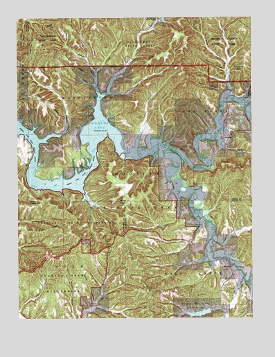
Elkinsville, IN USGS Topographic Map
Click on map above to begin viewing in our Map Viewer.

This topographic map contains these locations and features:
Feature Name Type Latitude Longitude GNIS ID View Map
Axsom BranchStreamN39.0517°W86.3394°450638View Map
Axsom Branch PondLakeN39.0564°W86.3310°451666View Map
Bad HollowValleyN39.0439°W86.2737°451668View Map
Bales HollowValleyN39.1065°W86.2632°450649View Map
Bret Kimberlin LakeReservoirN39.0234°W86.2867°451767View Map
Bret Kimberlin Lake DamDamN39.0234°W86.2867°451766View Map
Brown County State ParkParkN39.1137°W86.2647°450716View Map
Brown HollowValleyN39.0936°W86.2653°450717View Map
Browning HillSummitN39.0639°W86.2619°450719View Map
Callahan HollowValleyN39.0054°W86.3332°452254View Map
Charles C Deam WildernessReserveN39.0354°W86.3534°451825View Map
Charles C. Deam WildernessReserveN39.0367°W86.3517°2035083View Map
Combs BranchStreamN39.0414°W86.2778°450789View Map
Combs CreekStreamN39.0320°W86.2711°450790View Map
Cope HollowValleyN39.0032°W86.3746°450802View Map
Crooked CreekStreamN39.0939°W86.3275°450817View Map
Crooked Creek ChurchChurchN39.1075°W86.3139°450818View Map
Crooked Creek LakeReservoirN39.1244°W86.2970°450819View Map
Crooked Creek Lake DamDamN39.1237°W86.2994°451799View Map
Deckard ChurchChurchN39.0837°W86.3364°450835View Map
Deckard RidgeRidgeN39.0895°W86.3597°450836View Map
Dewar RidgeRidgeN39.1062°W86.3439°450846View Map
Eel CreekStreamN39.0781°W86.3489°450885View Map
ElkinsvillePopulated PlaceN39.0762°W86.2647°450887View Map
Elkinsville CemeteryCemeteryN39.0885°W86.2619°450888View Map
Fleetwood BranchStreamN39.0262°W86.2742°450916View Map
Forman HollowValleyN39.0928°W86.2527°450923View Map
Frank Grubb RidgeRidgeN39.0362°W86.3630°450930View Map
Geiger Ridge PondLakeN39.0081°W86.3628°451671View Map
Gilmore RidgeRidgeN39.1181°W86.3597°450961View Map
Hickory RidgeRidgeN39.0209°W86.3114°451034View Map
Hickory Ridge Lookout TowerTowerN39.0348°W86.3217°451035View Map
Hunter Creek ChurchChurchN39.0053°W86.3339°451072View Map
Hunter Creek PondLakeN39.0250°W86.3236°451669View Map
Jay PondLakeN39.0160°W86.3492°451670View Map
John Grubb RidgeRidgeN39.0456°W86.3542°451103View Map
Jones BranchStreamN39.0673°W86.3017°451105View Map
Lake TarzianReservoirN39.0021°W86.2782°451685View Map
Lake Tarzian DamDamN39.0028°W86.2722°451738View Map
Lincoln Back BranchStreamN39.0206°W86.2714°451672View Map
Little Blue CreekStreamN39.0917°W86.2630°451152View Map
Lucas HollowValleyN39.1025°W86.3325°451183View Map
Martin HollowValleyN39.0063°W86.3347°451198View Map
MaumeePopulated PlaceN39.0212°W86.2617°451203View Map
Maumee Boy Scout ReservationLocaleN39.0028°W86.2828°451855View Map
May BranchStreamN39.0978°W86.2639°451831View Map
Middle Fork State Wildlife RefugeParkN39.0559°W86.3569°451829View Map
Miller RidgeRidgeN39.1106°W86.2980°451223View Map
Moore HollowValleyN39.0973°W86.3342°451236View Map
Mose Ray BranchStreamN39.0095°W86.3308°451240View Map
Negro CreekStreamN39.0170°W86.2547°451271View Map
Panther CreekStreamN39.0934°W86.3272°451311View Map
Petro HollowValleyN39.1029°W86.2641°451330View Map
Porter HollowValleyN39.0742°W86.2983°451360View Map
Robertson CemeteryCemeteryN39.0378°W86.2768°451400View Map
Shaw HollowValleyN39.1080°W86.3379°453065View Map
Smoky HollowValleyN39.0930°W86.3311°451475View Map
South Fork Salt CreekStreamN39.0703°W86.2958°451483View Map
Spanker BranchStreamN39.0712°W86.2644°451487View Map
Starnes BranchStreamN39.0028°W86.2636°451509View Map
Swain BranchStreamN39.0837°W86.2694°451532View Map
Sycamore BranchStreamN39.0509°W86.2894°444506View Map
Taylor BranchStreamN39.0048°W86.3339°451543View Map
Terrill CemeteryCemeteryN39.0551°W86.3199°451550View Map
Terrill RidgeRidgeN39.0562°W86.3200°451551View Map
Terrill Ridge PondLakeN39.0571°W86.3181°451830View Map
Terrill Ridge RoadReservoirN39.0573°W86.3180°451667View Map
Warren LakeReservoirN39.0626°W86.3254°448716View Map
Will Hay BranchStreamN39.0712°W86.3117°451628View Map
Youno (historical)Populated PlaceN39.0739°W86.3167°451655View Map

Note: Coordinates in the location and feature list above are referenced to NAD83 datum.


Copyright (C) 2008-2024 Ryan Niemi / Sunset Dynamics ... All Rights Reserved