TopoQuest Logo
Do you find TopoQuest useful?
Help keep TopoQuest running and adding new maps/features by donating!
Bitcoin:  19c7KJd3qBynnjoSw5npx9KScwjBe4ifkT
Litecoin:  LXs6TkuXGGXo1vDsWCkWVdjQX94eUKd6ui
Home View Maps Find Maps Find Places Resources & Links


Eagar, Arizona Topographic Map

USGS Map Title: Eagar, AZ
USGS Map MRC: 34109A3
DRG (GeoTIFF) Download: o34109a3.tif


Neighboring USGS Topographic Map Quads:


  Springerville NW, AZ  
34109B4
 

  Springerville, AZ  
34109B3
 

  Coyote Hills, AZ  
34109B2
 

  Greer, AZ  
34109A4
 

  Eagar, AZ  
34109A3
 

  Nelson Reservoir, AZ  
34109A2
 

  Big Lake North, AZ  
33109H4
 

  Rudd Knoll, AZ  
33109H3
 

  Nutrioso, AZ  
33109H2


Map MRC Location:

N35°
W110°
N35°
W109°
H8 H7 H6 H5 H4 H3 H2 H1
G8 G7 G6 G5 G4 G3 G2 G1
F8 F7 F6 F5 F4 F3 F2 F1
E8 E7 E6 E5 E4 E3 E2 E1
D8 D7 D6 D5 D4 D3 D2 D1
C8 C7 C6 C5 C4 C3 C2 C1
B8 B7 B6 B5 B4 B3 B2 B1
A8 A7 A6 A5 A4 A3 A2 A1
N34°
W110°
N34°
W109°

Eagar, AZ USGS 1:24K Topographic Map Preview:
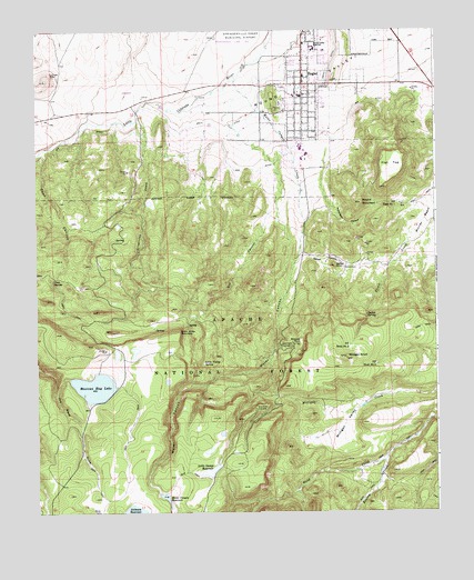
Eagar, AZ USGS Topographic Map
Click on map above to begin viewing in our Map Viewer.

This topographic map contains these locations and features:
Feature Name Type Latitude Longitude GNIS ID View Map
Amity DitchCanalN34.0987°W109.3159°25634View Map
Atcheson DamDamN34.0023°W109.3454°39002View Map
Athletic DomeSummitN34.1203°W109.2848°1853719View Map
Baca SpringSpringN34.0070°W109.3573°41608View Map
Benton CreekStreamN34.0131°W109.2668°26224View Map
Big DitchCanalN34.0887°W109.3062°26256View Map
Bigelow SpringSpringN34.0667°W109.3584°39005View Map
Bigelow TankReservoirN34.0718°W109.3503°1853663View Map
Browns ParkFlatN34.0445°W109.2926°26797View Map
Canvasback SinkBasinN34.0414°W109.3448°41634View Map
Canyon DamDamN34.0050°W109.3373°39019View Map
Canyon TankReservoirN34.0304°W109.2657°1852025View Map
CB Tank Number TwoReservoirN34.0305°W109.3454°41611View Map
Coon CanyonValleyN34.0931°W109.3720°27884View Map
Coon SpringSpringN34.0602°W109.3700°27889View Map
Cottonwood TankReservoirN34.0035°W109.2524°41612View Map
Division TankReservoirN34.0201°W109.3463°41606View Map
Dry CanyonValleyN34.0787°W109.3009°28615View Map
Duker SpringSpringN34.0002°W109.3589°1852030View Map
EagarPopulated PlaceN34.1112°W109.2915°28719View Map
Eagar Elementary SchoolSchoolN34.1078°W109.2923°39038View Map
Eagar Fire DepartmentBuildingN34.1129°W109.2871°2672341View Map
Eagar Police DepartmentBuildingN34.1078°W109.2912°2672263View Map
Eagar Post OfficePost OfficeN34.1106°W109.2942°2670490View Map
Eagar-Slade DamDamN34.0000°W109.3340°39039View Map
Eldeberry SpringSpringN34.0425°W109.3001°41616View Map
Elderberry Spring CampgroundLocaleN34.0434°W109.2990°28845View Map
Fat TankReservoirN34.0735°W109.3198°41625View Map
Flat TopSummitN34.0889°W109.2645°29060View Map
Grandview OverlookLocaleN34.0270°W109.3070°29468View Map
Grapevine CanyonValleyN34.1042°W109.3431°41622View Map
Grapevine CreekStreamN34.1017°W109.3418°29510View Map
Grapevine SpringSpringN34.0581°W109.3490°1852029View Map
Greer Lakes Golf ResortLocaleN34.1165°W109.3092°2669906View Map
Hay SpringSpringN34.0231°W109.3616°41605View Map
Head SpringSpringN34.0204°W109.3465°1852031View Map
Henry Slade SpringSpringN34.0698°W109.2923°39056View Map
Heron MarshSwampN34.0423°W109.3334°41609View Map
Kingdom Hall of Jehovahs WitnessesChurchN34.1162°W109.2552°2671202View Map
Little George ReservoirReservoirN34.0110°W109.3206°31066View Map
Little Valley SpringSpringN34.0385°W109.3234°31142View Map
Loon SinkBasinN34.0412°W109.3504°41635View Map
Lower Trick TankReservoirN34.0618°W109.3256°1852020View Map
Mexican Hay LakeReservoirN34.0326°W109.3571°31781View Map
Milligan KnollSummitN34.0398°W109.2784°31889View Map
Milligan Saddle SpringSpringN34.0287°W109.2935°1852022View Map
Milligan ValleyValleyN34.0270°W109.2748°31892View Map
Milligan Valley Creek Spring Number 1SpringN34.0276°W109.2743°1852024View Map
Milligan Valley Tank Number 1ReservoirN34.0191°W109.2886°41620View Map
Milligan Valley Tank Number 2ReservoirN34.0278°W109.2733°41617View Map
Northland Pioneer College Springerville - Eagar CenterSchoolN34.1211°W109.2919°2672188View Map
Number Four TankReservoirN34.0197°W109.3288°41607View Map
Perm TankReservoirN34.0020°W109.2685°41613View Map
Point Mountain TankReservoirN34.0404°W109.3321°41610View Map
Point of Mountain SpringSpringN34.0488°W109.3280°39109View Map
Point of the MountainCliffN34.0473°W109.3304°33070View Map
Point of the Mountain SpringSpringN34.0402°W109.3317°1852023View Map
Renaissance Academy Malpais CampusSchoolN34.1174°W109.2907°2543512View Map
Rim Creek SpringSpringN34.0475°W109.3383°1853544View Map
Rim SpringSpringN34.0481°W109.3390°41614View Map
Robertson HollowValleyN34.0939°W109.2843°33679View Map
Robertson TankReservoirN34.0747°W109.2720°41626View Map
Robinson TankReservoirN34.0754°W109.2792°1852026View Map
Rose TankReservoirN34.0207°W109.2841°41619View Map
RosebudPopulated PlaceN34.0006°W109.2673°33804View Map
Round MountainSummitN34.0800°W109.2737°33825View Map
Round ValleyValleyN34.1162°W109.3087°33836View Map
Round Valley Elementary SchoolSchoolN34.1082°W109.2842°1853735View Map
Round Valley High SchoolSchoolN34.1206°W109.2879°33837View Map
Round Valley Middle SchoolSchoolN34.1085°W109.2940°1853736View Map
Round Valley Primary SchoolSchoolN34.1247°W109.2753°1853737View Map
Round Valley Public LibraryBuildingN34.1078°W109.2912°2669470View Map
Saffell CanyonValleyN34.0675°W109.2923°33939View Map
Saffell KnollSummitN34.0639°W109.2820°33940View Map
Saffell SpringSpringN34.0510°W109.2723°33941View Map
Saffell tankReservoirN34.0610°W109.2807°41615View Map
Sattell Knoll SubstationLocaleN34.0634°W109.2790°39133View Map
Sawmill SpringSpringN34.0581°W109.3512°39135View Map
Sawmill TankReservoirN34.0609°W109.3523°41623View Map
Section Ten TankReservoirN34.0178°W109.2780°41618View Map
Spec TnakReservoirN34.0255°W109.3657°41633View Map
Stock Dam Number TwoReservoirN34.0112°W109.3523°41603View Map
Stock Tank Number ThreeReservoirN34.0184°W109.3477°41604View Map
T T Tank Number OneReservoirN34.0804°W109.2627°35072View Map
T T Tank Number ThreeReservoirN34.0382°W109.2693°35074View Map
T T Tank Number TwoReservoirN34.0430°W109.2779°35073View Map
T T WellWellN34.0800°W109.2615°35075View Map
The Church of Jesus Christ of Latter Day SaintsChurchN34.1132°W109.2909°2671357View Map
Town of EagarCivilN34.1058°W109.2956°2412455View Map
Upper Trick TankReservoirN34.0806°W109.3213°1852021View Map
Wad SpringSpringN34.0639°W109.3515°1852027View Map
Wad TankReservoirN34.0630°W109.3494°41624View Map
Wahl Knoll SpringSpringN34.0085°W109.3747°1852032View Map
Water CanyonValleyN34.1120°W109.3123°35916View Map
Water Canyon CreekStreamN34.1134°W109.3126°35919View Map
Water Canyon Ranger StationLocaleN34.0656°W109.2943°43436View Map
Water Canyon ReservoirReservoirN34.0038°W109.3352°35920View Map

Note: Coordinates in the location and feature list above are referenced to NAD83 datum.


Copyright (C) 2008-2024 Ryan Niemi / Sunset Dynamics ... All Rights Reserved