TopoQuest Logo
Do you find TopoQuest useful?
Help keep TopoQuest running and adding new maps/features by donating!
Bitcoin:  19c7KJd3qBynnjoSw5npx9KScwjBe4ifkT
Litecoin:  LXs6TkuXGGXo1vDsWCkWVdjQX94eUKd6ui
Home View Maps Find Maps Find Places Resources & Links


Dumas, Arkansas Topographic Map

USGS Map Title: Dumas, AR
USGS Map MRC: 33091H4
DRG (GeoTIFF) Download: o33091h4.tif


Neighboring USGS Topographic Map Quads:


  Cades, AR  
34091A5
 

  Gillett, AR  
34091A4
 

  Arkansas Post, AR  
34091A3
 

  Gould, AR  
33091H5
 

  Dumas, AR  
33091H4
 

  Watson, AR  
33091H3
 

  Gourd, AR  
33091G5
 

  Winchester, AR  
33091G4
 

  Kelso, AR  
33091G3


Map MRC Location:

N34°
W92°
N34°
W91°
H8 H7 H6 H5 H4 H3 H2 H1
G8 G7 G6 G5 G4 G3 G2 G1
F8 F7 F6 F5 F4 F3 F2 F1
E8 E7 E6 E5 E4 E3 E2 E1
D8 D7 D6 D5 D4 D3 D2 D1
C8 C7 C6 C5 C4 C3 C2 C1
B8 B7 B6 B5 B4 B3 B2 B1
A8 A7 A6 A5 A4 A3 A2 A1
N33°
W92°
N33°
W91°

Dumas, AR USGS 1:24K Topographic Map Preview:
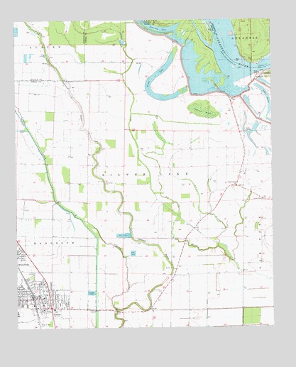
Dumas, AR USGS Topographic Map
Click on map above to begin viewing in our Map Viewer.

This topographic map contains these locations and features:
Feature Name Type Latitude Longitude GNIS ID View Map
Atkins SloughStreamN33.9093°W91.4012°45968View Map
Back GatePopulated PlaceN33.9326°W91.3929°45995View Map
Bethel ChurchChurchN33.9757°W91.4748°46443View Map
Brookhaven Shopping CenterLocaleN33.8829°W91.4826°63804View Map
Calvary Missionary Baptist ChurchChurchN33.8934°W91.4865°63794View Map
Carter Shopping CenterLocaleN33.8843°W91.4843°63803View Map
Central Elementary SchoolSchoolN33.8885°W91.4894°63802View Map
City of DumasCivilN33.8848°W91.4863°2403515View Map
City of MitchellvilleCivilN33.9051°W91.4984°2404276View Map
Cypress BrakeSwampN33.9627°W91.4087°48295View Map
Daniel Chapel Baptist ChurchChurchN33.9270°W91.3798°76745View Map
Dayton BayouStreamN33.9023°W91.3940°48405View Map
Desha County MuseumBuildingN33.8823°W91.4679°63808View Map
DumasPopulated PlaceN33.8870°W91.4918°48697View Map
Dumas Church of ChristChurchN33.8823°W91.4685°63807View Map
Dumas Emergency Medical ServicesBuildingN33.8877°W91.4903°2119047View Map
Dumas Fire DepartmentBuildingN33.8877°W91.4903°2116373View Map
Dumas High SchoolSchoolN33.8771°W91.4705°63806View Map
Dumas Junior High SchoolSchoolN33.8847°W91.4871°63799View Map
Dumas Nursing CenterBuildingN33.8848°W91.4793°63797View Map
Dumas Police DepartmentBuildingN33.8877°W91.4908°2118644View Map
Dumas Post OfficePost OfficeN33.8870°W91.4932°84253View Map
Dumas Public LibraryBuildingN33.8857°W91.4851°63801View Map
Echubby LakeLakeN33.9958°W91.4266°74815View Map
First Assembly of God ChurchChurchN33.8773°W91.4732°63805View Map
First Baptist Church of DumasChurchN33.8873°W91.4893°63798View Map
First Delta ChurchChurchN33.8895°W91.4301°49058View Map
First United Methodist ChurchChurchN33.8859°W91.4896°63793View Map
Havis ChapelChurchN33.8820°W91.4526°49943View Map
Holy Child Catholic ChurchChurchN33.8873°W91.4798°63796View Map
Jerusalem CemeteryCemeteryN33.9379°W91.3809°50631View Map
Lake LenoxLakeN33.9544°W91.3824°74943View Map
Lake LenoxLakeN33.9714°W91.3792°74944View Map
Leach CemeteryCemeteryN33.9479°W91.4579°51020View Map
Memorial ParkParkN33.8765°W91.4862°63862View Map
MitchellvillePopulated PlaceN33.9057°W91.4990°58200View Map
Mitchellville Fire DepartmentBuildingN33.9059°W91.4982°2116802View Map
Mitchellville Police DepartmentBuildingN33.9057°W91.4982°2118649View Map
Mount Zion ChurchChurchN33.8993°W91.4237°52460View Map
Mud LakeLakeN33.9779°W91.4129°63809View Map
Northside Baptist ChurchChurchN33.8907°W91.4807°63795View Map
Oak Log BayouStreamN33.9023°W91.3940°52939View Map
OaklawnPopulated PlaceN33.9112°W91.4307°63810View Map
Oakwood BayouStreamN33.8818°W91.4515°52972View Map
PendletonPopulated PlaceN33.9773°W91.3821°58342View Map
Pendleton FerryLocaleN33.9820°W91.3815°53266View Map
Reed Elementary SchoolSchoolN33.8810°W91.4993°63792View Map
Saint Stevens ChurchChurchN33.9337°W91.4565°54478View Map
Silver LakeLakeN33.9694°W91.4319°75127View Map
Southeast Arkansas Law Enforcement Center - Desha County Sheriff SubstationBuildingN33.9000°W91.4912°2118646View Map
Southeast Arkansas Law Enforcement Center Highway Patrol StationBuildingN33.8994°W91.4912°2118647View Map
Southeast Arkansas Law Enforcement Center- Alcohol Tobacco And FirearmsBuildingN33.9000°W91.4912°2118648View Map
Southeast Arkansas Law Enforcement Center- State Police Troop EBuildingN33.8999°W91.4912°2118645View Map
Township of Silver LakeCivilN33.9405°W91.4327°66506View Map

Note: Coordinates in the location and feature list above are referenced to NAD83 datum.


Copyright (C) 2008-2024 Ryan Niemi / Sunset Dynamics ... All Rights Reserved