TopoQuest Logo
Do you find TopoQuest useful?
Help keep TopoQuest running and adding new maps/features by donating!
Bitcoin:  19c7KJd3qBynnjoSw5npx9KScwjBe4ifkT
Litecoin:  LXs6TkuXGGXo1vDsWCkWVdjQX94eUKd6ui
Home View Maps Find Maps Find Places Resources & Links


Downsville, New York Topographic Map

USGS Map Title: Downsville, NY
USGS Map MRC: 42074A8
DRG (GeoTIFF) Download: o42074a8.tif


Neighboring USGS Topographic Map Quads:


  Walton East, NY  
42075B1
 

  Hamden, NY  
42074B8
 

  Andes, NY  
42074B7
 

  Corbett, NY  
42075A1
 

  Downsville, NY  
42074A8
 

  Lewbeach, NY  
42074A7
 

  Horton, NY  
41075H1
 

  Roscoe, NY  
41074H8
 

  Livingston Manor, NY  
41074H7


Map MRC Location:

N43°
W75°
N43°
W74°
H8 H7 H6 H5 H4 H3 H2 H1
G8 G7 G6 G5 G4 G3 G2 G1
F8 F7 F6 F5 F4 F3 F2 F1
E8 E7 E6 E5 E4 E3 E2 E1
D8 D7 D6 D5 D4 D3 D2 D1
C8 C7 C6 C5 C4 C3 C2 C1
B8 B7 B6 B5 B4 B3 B2 B1
A8 A7 A6 A5 A4 A3 A2 A1
N42°
W75°
N42°
W74°

Downsville, NY USGS 1:24K Topographic Map Preview:
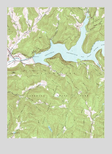
Downsville, NY USGS Topographic Map
Click on map above to begin viewing in our Map Viewer.

This topographic map contains these locations and features:
Feature Name Type Latitude Longitude GNIS ID View Map
Brock MountainSummitN42.0526°W74.9032°944800View Map
Bryden Hill BrookStreamN42.1148°W74.8985°945001View Map
Cables LakeLakeN42.0092°W74.9447°945418View Map
Campbell MountainSummitN42.0568°W74.9479°945705View Map
Cat HollowValleyN42.0692°W74.9464°946013View Map
Central SchoolSchoolN42.0787°W74.9979°946274View Map
Cherry RidgeRidgeN42.0204°W74.9638°946525View Map
Coles CloveValleyN42.1204°W74.8962°947120View Map
Conklin HillSummitN42.1048°W74.9232°947294View Map
Doe BrookStreamN42.1020°W74.9710°948529View Map
Downs BrookStreamN42.0759°W74.9913°948620View Map
DownsvillePopulated PlaceN42.0809°W74.9957°948622View Map
Downsville Census Designated PlaceCensusN42.0819°W74.9979°2628045View Map
Downsville Covered BridgeBridgeN42.0764°W74.9908°2097338View Map
Downsville Fire StationBuildingN42.0795°W74.9945°2718663View Map
Downsville Post OfficePost OfficeN42.0800°W74.9949°2780781View Map
Edwards PondLakeN42.0056°W74.9903°949412View Map
Fall CloveValleyN42.1150°W74.8910°949876View Map
Fuller HillSummitN42.0204°W74.9913°950782View Map
Gregory HollowValleyN42.0761°W74.9947°951796View Map
Hawks HollowValleyN42.0395°W74.9838°952409View Map
Holliday BrookStreamN42.0768°W74.8891°952998View Map
Huntley HollowValleyN42.0936°W74.9437°953503View Map
Little Spring BrookStreamN42.0179°W74.8896°955699View Map
Money PointCliffN42.1001°W74.9954°957508View Map
Murphy Hill BrookStreamN42.1023°W74.8988°958185View Map
Paige CemeteryCemeteryN42.0787°W74.9889°959757View Map
Pond HollowValleyN42.0320°W74.9643°960895View Map
Renard HillSummitN42.0962°W74.9596°962380View Map
Sugarloaf MountainSummitN42.0687°W74.9268°966728View Map
Telford HollowValleyN42.0943°W74.9849°967125View Map
Tiffany HollowValleyN42.1137°W74.9577°967518View Map
Town of ColchesterCivilN42.0418°W74.9585°978848View Map
Wilson HollowValleyN42.0851°W74.9971°971420View Map
Wilson Hollow BrookStreamN42.0829°W74.9932°971421View Map

Note: Coordinates in the location and feature list above are referenced to NAD83 datum.


Copyright (C) 2008-2024 Ryan Niemi / Sunset Dynamics ... All Rights Reserved