TopoQuest Logo
Do you find TopoQuest useful?
Help keep TopoQuest running and adding new maps/features by donating!
Bitcoin:  19c7KJd3qBynnjoSw5npx9KScwjBe4ifkT
Litecoin:  LXs6TkuXGGXo1vDsWCkWVdjQX94eUKd6ui
Home View Maps Find Maps Find Places Resources & Links


Doubletop Mountain, Maine Topographic Map

USGS Map Title: Doubletop Mountain, ME
USGS Map MRC: 45069H1
DRG (GeoTIFF) Download: o45069h1.tif


Neighboring USGS Topographic Map Quads:


  Telos Brook, ME  
46069A2
 

  Nesowadnehunk Lake, ME  
46069A1
 

  Wassataquoik Lake, ME  
46068A8
 

  Harrington Lake, ME  
45069H2
 

  Doubletop Mountain, ME  
45069H1
 

  Mount Katahdin, ME  
45068H8
 

  Rainbow Lake West, ME  
45069G2
 

  Rainbow Lake East, ME  
45069G1
 

  Abol Pond, ME  
45068G8


Map MRC Location:

N46°
W70°
N46°
W69°
H8 H7 H6 H5 H4 H3 H2 H1
G8 G7 G6 G5 G4 G3 G2 G1
F8 F7 F6 F5 F4 F3 F2 F1
E8 E7 E6 E5 E4 E3 E2 E1
D8 D7 D6 D5 D4 D3 D2 D1
C8 C7 C6 C5 C4 C3 C2 C1
B8 B7 B6 B5 B4 B3 B2 B1
A8 A7 A6 A5 A4 A3 A2 A1
N45°
W70°
N45°
W69°

Doubletop Mountain, ME USGS 1:24K Topographic Map Preview:
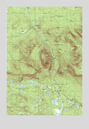
Doubletop Mountain, ME USGS Topographic Map
Click on map above to begin viewing in our Map Viewer.

This topographic map contains these locations and features:
Feature Name Type Latitude Longitude GNIS ID View Map
Bean Hole MountainSummitN45.9237°W69.1211°561783View Map
Beaver PondLakeN45.8871°W69.0795°561953View Map
Celia PondLakeN45.8920°W69.0682°563742View Map
Daicey PondLakeN45.8815°W69.0258°564737View Map
Deer PondLakeN45.9067°W69.0472°565002View Map
Doubletop MountainSummitN45.9359°W69.0612°565226View Map
Draper PondLakeN45.9011°W69.0448°565279View Map
Elbow PondLakeN45.8866°W69.0171°565829View Map
Foster FieldFlatN45.9034°W69.0367°581615View Map
Fowler PondLakeN45.8882°W69.0957°566504View Map
Grassy PondLakeN45.8840°W69.0076°567089View Map
Harrington PondLakeN45.9127°W69.1154°567681View Map
Jackson PondLakeN45.8943°W69.0741°568748View Map
Kidney PondLakeN45.8901°W69.0449°569157View Map
Ledge FallsFallsN45.9598°W69.0589°569440View Map
Lily Pad PondLakeN45.8770°W69.0421°569564View Map
Little Beaver PondLakeN45.8856°W69.0742°569675View Map
Little Nesowadnehunk StreamStreamN45.9753°W69.0767°569938View Map
Little Rocky PondLakeN45.9034°W69.0609°570029View Map
McKenna PondLakeN45.9090°W69.1022°571000View Map
McManus BrookStreamN45.9825°W69.0792°571026View Map
Moose BosomSummitN45.9334°W69.0858°576193View Map
Mount CoeSummitN45.9337°W69.0090°564149View Map
Mount O-J-ISummitN45.9278°W69.0151°572559View Map
Mount VetoSummitN45.9499°W69.0875°577716View Map
Nesowadnehunk Field CampLocaleN45.9731°W69.0859°575745View Map
Nesowaonehunk FieldFlatN45.9792°W69.0781°581614View Map
Polly PondLakeN45.9092°W69.0783°573579View Map
Roaring BrookStreamN45.9484°W69.0487°574275View Map
Rocky PondLakeN45.9005°W69.0565°574409View Map
Slaughter BrookStreamN45.8992°W69.0378°575546View Map
Slaughter PondLakeN45.9127°W69.0827°575547View Map
Slide DamDamN45.9403°W69.0425°1910181View Map
South BrotherSummitN45.9442°W69.0017°575826View Map
T3 R10 WELSCivilN45.9059°W69.0110°2748705View Map
T4 R10 WELSCivilN45.9934°W69.0191°2748663View Map
The Cross RangeRangeN45.9640°W69.0248°576788View Map
Tracy PondLakeN45.8909°W69.0131°577261View Map
Unorganized Territory of Northeast PiscataquisCivilN45.9180°W69.0898°582629View Map
West PeakSummitN45.9246°W69.0331°578188View Map
Williams PondLakeN45.9710°W69.0951°578523View Map

Note: Coordinates in the location and feature list above are referenced to NAD83 datum.


Copyright (C) 2008-2024 Ryan Niemi / Sunset Dynamics ... All Rights Reserved