TopoQuest Logo
Do you find TopoQuest useful?
Help keep TopoQuest running and adding new maps/features by donating!
Bitcoin:  19c7KJd3qBynnjoSw5npx9KScwjBe4ifkT
Litecoin:  LXs6TkuXGGXo1vDsWCkWVdjQX94eUKd6ui
Home View Maps Find Maps Find Places Resources & Links


Dorothy, West Virginia Topographic Map

USGS Map Title: Dorothy, WV
USGS Map MRC: 37081H4
DRG (GeoTIFF) Download: o37081h4.tif


Neighboring USGS Topographic Map Quads:


  Sylvester, WV  
38081A5
 

  Eskdale, WV  
38081A4
 

  Powellton, WV  
38081A3
 

  Whitesville, WV  
37081H5
 

  Dorothy, WV  
37081H4
 

  Pax, WV  
37081H3
 

  Pilot Knob, WV  
37081G5
 

  Arnett, WV  
37081G4
 

  Eccles, WV  
37081G3


Map MRC Location:

N38°
W82°
N38°
W81°
H8 H7 H6 H5 H4 H3 H2 H1
G8 G7 G6 G5 G4 G3 G2 G1
F8 F7 F6 F5 F4 F3 F2 F1
E8 E7 E6 E5 E4 E3 E2 E1
D8 D7 D6 D5 D4 D3 D2 D1
C8 C7 C6 C5 C4 C3 C2 C1
B8 B7 B6 B5 B4 B3 B2 B1
A8 A7 A6 A5 A4 A3 A2 A1
N37°
W82°
N37°
W81°

Dorothy, WV USGS 1:24K Topographic Map Preview:
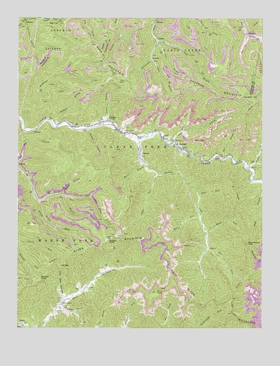
Dorothy, WV USGS Topographic Map
Click on map above to begin viewing in our Map Viewer.

This topographic map contains these locations and features:
Feature Name Type Latitude Longitude GNIS ID View Map
AmeaglePopulated PlaceN37.9498°W81.4187°1534917View Map
Ameagle Post OfficePost OfficeN37.9471°W81.4162°1742657View Map
Bacon HollowValleyN37.9290°W81.4776°1535108View Map
Beetree BranchStreamN37.9282°W81.4754°1535580View Map
Boyd Branch KnobSummitN37.9090°W81.3823°1536276View Map
Brushy ForkStreamN37.9257°W81.4887°1536494View Map
Coal River MountainSummitN37.8854°W81.4121°1537465View Map
ColcordPopulated PlaceN37.9443°W81.4371°1537501View Map
Culvert HollowValleyN37.9973°W81.4957°1537903View Map
Davis ForkStreamN37.9151°W81.4043°1538043View Map
DorothyPopulated PlaceN37.9551°W81.4496°1538274View Map
Dorothy Post OfficePost OfficeN37.9577°W81.4744°1742733View Map
Dow ForkStreamN37.9546°W81.4157°1538302View Map
EmersonPopulated PlaceN37.9409°W81.4976°1553683View Map
Estep-Bailey CemeteryCemeteryN37.9514°W81.4218°2586175View Map
Fulton CemeteryCemeteryN37.9415°W81.3804°1539298View Map
Fulton CreekStreamN37.9398°W81.3804°1539299View Map
Fulton School (historical)SchoolN37.9404°W81.3826°1742768View Map
Gardner BranchStreamN37.9565°W81.4798°1539334View Map
Gibson BranchStreamN37.9834°W81.4326°1539383View Map
High CoalLocaleN37.9984°W81.4793°1540243View Map
Hill CemeteryCemeteryN37.9590°W81.4582°1540281View Map
Hodge CemeteryCemeteryN37.9440°W81.3987°1540330View Map
Hope School (historical)SchoolN37.9562°W81.4709°1540440View Map
Horse Creek ChurchChurchN37.8854°W81.4768°1540483View Map
Jarrell CemeteryCemeteryN37.8865°W81.4771°1540826View Map
Jarrell School (historical)SchoolN37.8854°W81.4757°1742808View Map
Kayford MountainSummitN37.9698°W81.3821°1541091View Map
Laurel BranchStreamN37.9584°W81.4546°1541377View Map
Lem ForkStreamN37.9076°W81.4023°1541777View Map
Long BranchStreamN37.9504°W81.4207°1542339View Map
Long BranchStreamN37.9907°W81.4293°1542343View Map
Low GapGapN37.9001°W81.4779°1542493View Map
Low Gap HollowValleyN37.8865°W81.4762°1542508View Map
Mare BranchStreamN37.9437°W81.3943°1542755View Map
Miller CemeteryCemeteryN37.8829°W81.4768°1543359View Map
NotomineLocaleN37.9843°W81.4323°1544244View Map
Panther BranchStreamN37.9559°W81.4640°1544543View Map
Pettry CemeteryCemeteryN37.8762°W81.4965°1544760View Map
Pheasant ForkStreamN37.9096°W81.4998°1544772View Map
Pond KnobSummitN37.8896°W81.4287°1545130View Map
Raines ForkStreamN37.9196°W81.4062°1545385View Map
Right Fork Sycamore CreekStreamN37.9368°W81.4293°1545713View Map
Rollyson HollowValleyN37.8843°W81.4771°1546053View Map
Short BranchStreamN37.9896°W81.4301°1546718View Map
Slip Ridge BranchStreamN37.9279°W81.4632°1546946View Map
Speed BranchStreamN37.9398°W81.4340°1547120View Map
Squealer KnobSummitN37.8940°W81.4879°1547292View Map
Stanley CemeteriesCemeteryN37.9748°W81.4487°1547332View Map
Stonecoal CreekStreamN37.9540°W81.4309°1547466View Map
Stover CemeteryCemeteryN37.9393°W81.3807°1547531View Map
Stover ForkStreamN37.9287°W81.4076°1547534View Map
Sycamore CreekStreamN37.9512°W81.4384°1547825View Map
Sycamore School (historical)SchoolN37.9323°W81.4101°1742987View Map
Truax-Traer Coal Company SpringSpringN37.9868°W81.4468°1678148View Map
Union CemeteryCemeteryN37.9548°W81.4451°1548464View Map
UnitedPopulated PlaceN37.9907°W81.4265°1555854View Map
William CemeteryCemeteryN37.8818°W81.4798°1549160View Map
Wriston KnobSummitN37.9109°W81.4532°1556029View Map
Wriston Knob Lookout TowerLocaleN37.9107°W81.4534°1743025View Map

Note: Coordinates in the location and feature list above are referenced to NAD83 datum.


Copyright (C) 2008-2024 Ryan Niemi / Sunset Dynamics ... All Rights Reserved