TopoQuest Logo
Do you find TopoQuest useful?
Help keep TopoQuest running and adding new maps/features by donating!
Bitcoin:  19c7KJd3qBynnjoSw5npx9KScwjBe4ifkT
Litecoin:  LXs6TkuXGGXo1vDsWCkWVdjQX94eUKd6ui
Home View Maps Find Maps Find Places Resources & Links


Dixie, Mississippi Topographic Map

USGS Map Title: Dixie, MS
USGS Map MRC: 31089B3
DRG (GeoTIFF) Download: o31089b3.tif


Neighboring USGS Topographic Map Quads:


  Hattiesburg SW, MS  
31089C4
 

  Hattiesburg, MS  
31089C3
 

  Carterville, MS  
31089C2
 

  Purvis, MS  
31089B4
 

  Dixie, MS  
31089B3
 

  McLaurin, MS  
31089B2
 

  Lumberton, MS  
31089A4
 

  Rock Hill, MS  
31089A3
 

  Brooklyn, MS  
31089A2


Map MRC Location:

N32°
W90°
N32°
W89°
H8 H7 H6 H5 H4 H3 H2 H1
G8 G7 G6 G5 G4 G3 G2 G1
F8 F7 F6 F5 F4 F3 F2 F1
E8 E7 E6 E5 E4 E3 E2 E1
D8 D7 D6 D5 D4 D3 D2 D1
C8 C7 C6 C5 C4 C3 C2 C1
B8 B7 B6 B5 B4 B3 B2 B1
A8 A7 A6 A5 A4 A3 A2 A1
N31°
W90°
N31°
W89°

Dixie, MS USGS 1:24K Topographic Map Preview:
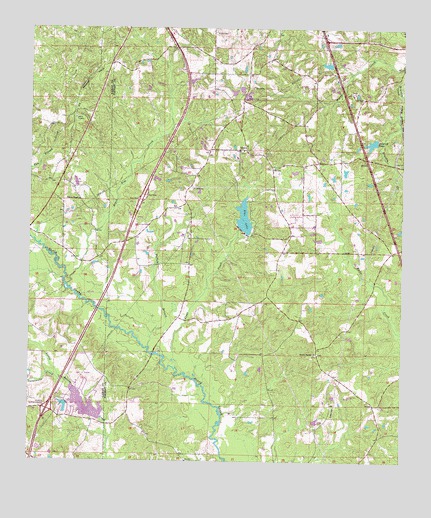
Dixie, MS USGS Topographic Map
Click on map above to begin viewing in our Map Viewer.

This topographic map contains these locations and features:
Feature Name Type Latitude Longitude GNIS ID View Map
Beaver LakeReservoirN31.1432°W89.3586°707449View Map
Bellecrest Mobile Home VillagePopulated PlaceN31.2459°W89.3298°2596802View Map
Black Tom CreekStreamN31.1757°W89.3628°667238View Map
Browns School (historical)SchoolN31.1830°W89.3237°683888View Map
Bufkins BranchStreamN31.1563°W89.3348°667763View Map
Central Forrest Attendance CenterSchoolN31.2163°W89.3026°706334View Map
Clark CemeteryCemeteryN31.2488°W89.3153°668504View Map
Clear CreekStreamN31.1518°W89.3256°668549View Map
DixiePopulated PlaceN31.2152°W89.3037°691818View Map
Dixie Baptist ChurchChurchN31.2145°W89.3059°683896View Map
Dixie CemeteryCemeteryN31.2149°W89.3042°706338View Map
Dixie Recreation CenterBuildingN31.2173°W89.3028°2596933View Map
Dixie United Methodist ChurchChurchN31.2153°W89.3036°2596835View Map
Dixie Volunteer Fire DepartmentBuildingN31.2218°W89.3060°2332813View Map
Elk Lake DamDamN31.2285°W89.3034°680623View Map
Elks LakeReservoirN31.1954°W89.3032°669725View Map
Forrest CountyCivilN31.1889°W89.2579°695742View Map
Interchange 51CrossingN31.1399°W89.3687°691606View Map
Interstate 59 North Roadside ParkLocaleN31.2031°W89.3361°2596310View Map
Lake Beaver DamDamN31.1402°W89.3534°680591View Map
Lake Beaver DamDamN31.1418°W89.3617°680592View Map
Lamar Pines Mobile Home CommunityPopulated PlaceN31.2056°W89.3576°2596619View Map
Mineral Springs Baptist ChurchChurchN31.1563°W89.2784°673670View Map
Mineral Springs CemeteryCemeteryN31.1563°W89.2781°706350View Map
Pine Creek Golf ClubLocaleN31.1517°W89.3567°2596668View Map
Pineview Baptist ChurchChurchN31.1429°W89.2572°2596157View Map
Rodgers School (historical)SchoolN31.2093°W89.2942°683950View Map
Sumrall LakeReservoirN31.2170°W89.2606°678407View Map
Supervisor District 1CivilN31.1845°W89.2903°711843View Map
Sweatmans CreekStreamN31.1488°W89.3642°678460View Map
Whites ChapelChurchN31.2005°W89.3590°679634View Map

Note: Coordinates in the location and feature list above are referenced to NAD83 datum.


Copyright (C) 2008-2024 Ryan Niemi / Sunset Dynamics ... All Rights Reserved