TopoQuest Logo
Do you find TopoQuest useful?
Help keep TopoQuest running and adding new maps/features by donating!
Bitcoin:  19c7KJd3qBynnjoSw5npx9KScwjBe4ifkT
Litecoin:  LXs6TkuXGGXo1vDsWCkWVdjQX94eUKd6ui
Home View Maps Find Maps Find Places Resources & Links


Diamond Peak, Washington Topographic Map

USGS Map Title: Diamond Peak, WA
USGS Map MRC: 46117A5
DRG (GeoTIFF) Download: o46117a5.tif


Neighboring USGS Topographic Map Quads:


  Panjab Creek, WA  
46117B6
 

  Stentz Spring, WA  
46117B5
 

  Pinkham Butte, WA  
46117B4
 

  Oregon Butte, WA  
46117A6
 

  Diamond Peak, WA  
46117A5
 

  Saddle Butte, WA  
46117A4
 

  Elbow Creek, OR  
45117H6
 

  Eden Ridge, OR  
45117H5
 

  Troy, OR  
45117H4


Map MRC Location:

N47°
W118°
N47°
W117°
H8 H7 H6 H5 H4 H3 H2 H1
G8 G7 G6 G5 G4 G3 G2 G1
F8 F7 F6 F5 F4 F3 F2 F1
E8 E7 E6 E5 E4 E3 E2 E1
D8 D7 D6 D5 D4 D3 D2 D1
C8 C7 C6 C5 C4 C3 C2 C1
B8 B7 B6 B5 B4 B3 B2 B1
A8 A7 A6 A5 A4 A3 A2 A1
N46°
W118°
N46°
W117°

Diamond Peak, WA USGS 1:24K Topographic Map Preview:
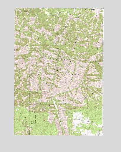
Diamond Peak, WA USGS Topographic Map
Click on map above to begin viewing in our Map Viewer.

This topographic map contains these locations and features:
Feature Name Type Latitude Longitude GNIS ID View Map
Bald ButteSummitN46.0876°W117.6085°1511980View Map
C H Neal RanchLocaleN46.0174°W117.5332°1514030View Map
Cecil Bott RanchLocaleN46.0001°W117.5057°1514031View Map
Chaparral BasinBasinN46.0854°W117.5613°1503912View Map
Cherry CreekStreamN46.0429°W117.5869°1503937View Map
Coyote CreekStreamN46.0335°W117.5691°1504224View Map
Crooked Creek TrailTrailN46.0424°W117.5757°1531605View Map
Diamond PeakSummitN46.1154°W117.5393°1512150View Map
Diamond SpringSpringN46.1188°W117.5452°1504475View Map
East Fork First CreekStreamN46.0713°W117.5196°1513102View Map
F Kessler RanchLocaleN46.0185°W117.5335°1533287View Map
Fairview SpringSpringN46.0090°W117.6074°1504811View Map
First CreekStreamN46.0349°W117.5702°1504892View Map
First Creek CabinLocaleN46.0365°W117.5677°1504893View Map
Halsey ButteSummitN46.0751°W117.5432°1512262View Map
Hunt SchoolSchoolN46.0143°W117.5218°1514032View Map
J R Evans RanchLocaleN46.0163°W117.5318°1514029View Map
July RidgeRidgeN46.0913°W117.5071°1505878View Map
July Ridge TrailTrailN46.1007°W117.5049°1510185View Map
Kelly CampLocaleN46.1207°W117.5060°1511518View Map
Melton CreekStreamN46.0421°W117.5757°1506620View Map
Melton Creek TrailTrailN46.0896°W117.5694°1510186View Map
Monument RidgeRidgeN46.0751°W117.5432°1506767View Map
Mount MiserySummitN46.1229°W117.5146°1506735View Map
Mud SpringSpringN46.0011°W117.6017°1506877View Map
Packer TrailTrailN46.0215°W117.5910°1510184View Map
Pistol SpringSpringN46.0119°W117.5978°1507472View Map
Saddle CreekStreamN46.0729°W117.5088°1507981View Map
Second CreekStreamN46.0424°W117.6032°1508198View Map
Sheephead CorralLocaleN46.1188°W117.5716°1508280View Map
Sheephead SpringSpringN46.1179°W117.5713°1508281View Map
Slide CanyonValleyN46.0315°W117.5669°1508412View Map
Smooth RidgeRidgeN46.0110°W117.5941°1508450View Map
Squaw SpringSpringN46.1240°W117.5865°1508667View Map
Third CreekStreamN46.0460°W117.6244°1508984View Map
West Fork First CreekStreamN46.0713°W117.5196°1509396View Map
Willow CreekStreamN46.0435°W117.5463°1509545View Map

Note: Coordinates in the location and feature list above are referenced to NAD83 datum.


Copyright (C) 2008-2024 Ryan Niemi / Sunset Dynamics ... All Rights Reserved