TopoQuest Logo
Do you find TopoQuest useful?
Help keep TopoQuest running and adding new maps/features by donating!
Bitcoin:  19c7KJd3qBynnjoSw5npx9KScwjBe4ifkT
Litecoin:  LXs6TkuXGGXo1vDsWCkWVdjQX94eUKd6ui
Home View Maps Find Maps Find Places Resources & Links


Diablo Dam, Washington Topographic Map

USGS Map Title: Diablo Dam, WA
USGS Map MRC: 48121F2
DRG (GeoTIFF) Download: o48121f2.tif


Neighboring USGS Topographic Map Quads:


  Mount Challenger, WA  
48121G3
 

  Mount Prophet, WA  
48121G2
 

  Pumpkin Mountain, WA  
48121G1
 

  Mount Triumph, WA  
48121F3
 

  Diablo Dam, WA  
48121F2
 

  Ross Dam, WA  
48121F1
 

  Big Devil Peak, WA  
48121E3
 

  Eldorado Peak, WA  
48121E2
 

  Forbidden Peak, WA  
48121E1


Map MRC Location:

N49°
W122°
N49°
W121°
H8 H7 H6 H5 H4 H3 H2 H1
G8 G7 G6 G5 G4 G3 G2 G1
F8 F7 F6 F5 F4 F3 F2 F1
E8 E7 E6 E5 E4 E3 E2 E1
D8 D7 D6 D5 D4 D3 D2 D1
C8 C7 C6 C5 C4 C3 C2 C1
B8 B7 B6 B5 B4 B3 B2 B1
A8 A7 A6 A5 A4 A3 A2 A1
N48°
W122°
N48°
W121°

Diablo Dam, WA USGS 1:24K Topographic Map Preview:
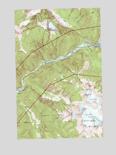
Diablo Dam, WA USGS Topographic Map
Click on map above to begin viewing in our Map Viewer.

This topographic map contains these locations and features:
Feature Name Type Latitude Longitude GNIS ID View Map
Bouck LakeLakeN48.6840°W121.1842°1516815View Map
Bucket CreekStreamN48.7310°W121.1621°1517048View Map
Camp Dayo CreekStreamN48.7340°W121.1704°1517272View Map
Colonial GlacierGlacierN48.6621°W121.1390°1517968View Map
Davis PeakSummitN48.7296°W121.2029°1518511View Map
DiabloPopulated PlaceN48.7135°W121.1412°1518740View Map
Diablo CanyonValleyN48.7130°W121.1526°1530514View Map
Diablo DamDamN48.7143°W121.1312°1518741View Map
East Fork Newhalem CreekStreamN48.6393°W121.2251°1519119View Map
Gorge CreekStreamN48.7001°W121.2082°1520163View Map
Gorge Creek BridgeBridgeN48.7010°W121.2094°2608024View Map
Gorge Creek FallsFallsN48.7015°W121.2104°1529797View Map
Gorge Creek Falls ViewpointLocaleN48.7015°W121.2107°1529796View Map
Gorge DamDamN48.6979°W121.2085°1520164View Map
Gorge LakeReservoirN48.7066°W121.1717°1520165View Map
Gorge PowerhouseLocaleN48.6754°W121.2401°1533126View Map
Jeanita LakeLakeN48.7455°W121.1397°1521342View Map
Ladder CreekStreamN48.6751°W121.2401°1521821View Map
Ladder Creek FallsFallsN48.6701°W121.2498°1530520View Map
Mount RossSummitN48.7094°W121.2446°1525225View Map
Neve GlacierGlacierN48.6462°W121.1412°1523630View Map
NewhalemPopulated PlaceN48.6737°W121.2473°1523641View Map
Newhalem / Diablo Volunteer Fire DepartmentBuildingN48.7187°W121.1484°2643636View Map
Newhalem Creek PowerhouseLocaleN48.6687°W121.2493°1533182View Map
Paul Bunyans StumpSummitN48.6657°W121.1500°1524257View Map
Pinnacle PeakSummitN48.6715°W121.1496°1524467View Map
Pyramid CreekStreamN48.7129°W121.1535°1524715View Map
Pyramid Lake Research Natural AreaAreaN48.6999°W121.1296°1529450View Map
Pyramid Lake TrailTrailN48.7015°W121.1346°1524718View Map
Pyramid PeakSummitN48.6745°W121.1461°1524725View Map
Reflector BarBarN48.7135°W121.1421°1530512View Map
Snowfield PeakSummitN48.6353°W121.1387°1526043View Map
Sourdough Lookout TrailTrailN48.7299°W121.1318°1526127View Map
Stephen Mather WildernessReserveN48.6905°W121.1456°2035312View Map
Stetattle CreekStreamN48.7171°W121.1493°1526546View Map
The HorsemanPillarN48.6373°W121.1546°1527036View Map
The NeedlePillarN48.6456°W121.1569°1527052View Map

Note: Coordinates in the location and feature list above are referenced to NAD83 datum.


Copyright (C) 2008-2024 Ryan Niemi / Sunset Dynamics ... All Rights Reserved