TopoQuest Logo
Do you find TopoQuest useful?
Help keep TopoQuest running and adding new maps/features by donating!
Bitcoin:  19c7KJd3qBynnjoSw5npx9KScwjBe4ifkT
Litecoin:  LXs6TkuXGGXo1vDsWCkWVdjQX94eUKd6ui
Home View Maps Find Maps Find Places Resources & Links


Culbertson, Montana Topographic Map

USGS Map Title: Culbertson, MT
USGS Map MRC: 48104B5
DRG (GeoTIFF) Download: o48104b5.tif


Neighboring USGS Topographic Map Quads:


  Rocky Point, MT  
48104C6
 

  Johnson Lake, MT  
48104C5
 

  Froid, MT  
48104C4
 

  Fort Kipp, MT  
48104B6
 

  Culbertson, MT  
48104B5
 

  McCabe West, MT  
48104B4
 

  Twomile Creek, MT  
48104A6
 

  Dugout Creek, MT  
48104A5
 

  Three Buttes, MT  
48104A4


Map MRC Location:

N49°
W105°
N49°
W104°
H8 H7 H6 H5 H4 H3 H2 H1
G8 G7 G6 G5 G4 G3 G2 G1
F8 F7 F6 F5 F4 F3 F2 F1
E8 E7 E6 E5 E4 E3 E2 E1
D8 D7 D6 D5 D4 D3 D2 D1
C8 C7 C6 C5 C4 C3 C2 C1
B8 B7 B6 B5 B4 B3 B2 B1
A8 A7 A6 A5 A4 A3 A2 A1
N48°
W105°
N48°
W104°

Culbertson, MT USGS 1:24K Topographic Map Preview:
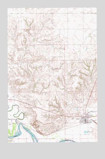
Culbertson, MT USGS Topographic Map
Click on map above to begin viewing in our Map Viewer.

This topographic map contains these locations and features:
Feature Name Type Latitude Longitude GNIS ID View Map
28N55E01CB__01 WellWellN48.2072°W104.5652°1634116View Map
28N55E22BB__01 WellWellN48.1709°W104.6086°1633810View Map
28N55E23ABDB01 WellWellN48.1695°W104.5747°1633799View Map
28N55E23AD__01 WellWellN48.1672°W104.5705°1633789View Map
28N55E24BA__01 WellWellN48.1709°W104.5597°1633809View Map
28N55E24DD__01 WellWellN48.1600°W104.5488°826849View Map
28N55E27AC__01 WellWellN48.1528°W104.5977°826781View Map
28N55E27BA__01 WellWellN48.1564°W104.6033°826817View Map
28N55E28CD__01 WellWellN48.1456°W104.6250°826701View Map
28N55E33DA__01 WellWellN48.1347°W104.6141°826576View Map
28N55E34AA__01 WellWellN48.1420°W104.5925°826649View Map
28N55E34AA__02 WellWellN48.1420°W104.5925°826650View Map
28N55E35AD__01 WellWellN48.1384°W104.5705°826604View Map
28N55E36AA__01 WellWellN48.1420°W104.5488°826646View Map
28N55E36AA__02 WellWellN48.1420°W104.5488°826647View Map
28N55E36AA__03 WellWellN48.1420°W104.5488°826648View Map
28N55E36BD__01 WellWellN48.1384°W104.5597°826603View Map
28N55E36CD__01 WellWellN48.1311°W104.5597°826538View Map
28N56E06AD__01 WellWellN48.2106°W104.5297°1634144View Map
28N56E07AA__01 WellWellN48.1997°W104.5297°1634053View Map
28N56E07ADCA01 WellWellN48.1956°W104.5275°1634016View Map
28N56E20CA__01 WellWellN48.1634°W104.5188°1633770View Map
28N56E20CB__01 WellWellN48.1634°W104.5244°1633771View Map
28N56E29AC__01 WellWellN48.1525°W104.5136°826772View Map
28N56E29BC__01 WellWellN48.1525°W104.5244°826773View Map
28N56E29BC__02 WellWellN48.1525°W104.5244°826774View Map
28N56E29BC__03 WellWellN48.1525°W104.5244°826775View Map
28N56E29CB__01 WellWellN48.1489°W104.5244°826727View Map
28N56E29CD__01 WellWellN48.1453°W104.5188°826689View Map
28N56E29DB__01 WellWellN48.1489°W104.5136°826726View Map
28N56E29DC__01 WellWellN48.1453°W104.5136°826688View Map
28N56E29DD__01 WellWellN48.1453°W104.5083°826687View Map
28N56E30CC__01 WellWellN48.1453°W104.5461°826691View Map
28N56E30DD__01 WellWellN48.1453°W104.5297°826690View Map
28N56E32AA__01 WellWellN48.1417°W104.5083°826642View Map
28N56E32DB__01 WellWellN48.1345°W104.5136°826572View Map
28N56E32DD__02 WellWellN48.1309°W104.5083°826527View Map
Bauer CemeteryCemeteryN48.1486°W104.6022°768563View Map
Bethel Free Lutheran ChurchChurchN48.1492°W104.5136°1669186View Map
Big Muddy CreekStreamN48.1417°W104.6119°768809View Map
Big Sky FieldAirportN48.1520°W104.5096°806396View Map
Bruegger Centennial ParkParkN48.1470°W104.5122°1669166View Map
C C Recreation ComplexParkN48.1500°W104.5186°1669164View Map
Clover CreekStreamN48.1331°W104.5119°799157View Map
CulbertsonPopulated PlaceN48.1445°W104.5169°770366View Map
CulbertsonLocaleN48.1436°W104.5150°1669402View Map
Culbertson Police DepartmentBuildingN48.1461°W104.5175°1669148View Map
Culbertson Post OfficePost OfficeN48.1467°W104.5165°1669403View Map
Culbertson Public LibraryBuildingN48.1453°W104.5177°1669228View Map
Culbertson SchoolSchoolN48.1475°W104.5205°1669265View Map
Culbertson Sewage Disposal Ponds DamDamN48.1350°W104.5172°798156View Map
Culbertson Volunteer Fire DepartmentBuildingN48.1466°W104.5174°1669149View Map
Damm School Number Two (historical)SchoolN48.2464°W104.6200°1669303View Map
Everson-Clayton Mortuary ChapelChurchN48.1459°W104.5180°1669185View Map
Farmers Elevator Company ElevatorLocaleN48.1431°W104.5172°1669178View Map
Finnicum Mobile Home ParkPopulated PlaceN48.1497°W104.5227°1669145View Map
First Baptist ChurchChurchN48.1459°W104.5177°1669192View Map
Fish CampLocaleN48.1436°W104.6133°771386View Map
Helton Nursing Home (historical)HospitalN48.1445°W104.5169°1669218View Map
Hillside CemeteryCemeteryN48.1472°W104.5336°772417View Map
LeClair School (historical)SchoolN48.2495°W104.5311°1669301View Map
Liberty School (historical)SchoolN48.2167°W104.6180°1669268View Map
Mrs Spiegelbergs Hospital (historical)HospitalN48.1445°W104.5169°1669217View Map
Newtons Maternity Hospital (historical)HospitalN48.1445°W104.5169°1669215View Map
Pleasant View School (historical)SchoolN48.2084°W104.5569°1669302View Map
Presbyterian Church (historical)ChurchN48.1445°W104.5169°1669191View Map
Reorganized Church of Jesus Christ of Latter Day SaintsChurchN48.1459°W104.5177°1669184View Map
Roosevelt County Sheriff's Office SubstationBuildingN48.1458°W104.5171°2548951View Map
Roosevelt Medical CenterHospitalN48.1515°W104.5147°1669225View Map
Roosevelt Memorial ClinicHospitalN48.1511°W104.5144°1669219View Map
Roosevelt Memorial Nursing HomeHospitalN48.1511°W104.5144°1669224View Map
Saint Anthonys Catholic ChurchChurchN48.1475°W104.5230°1669188View Map
Saint Pauls Lutheran Church (historical)ChurchN48.1445°W104.5169°1669190View Map
Saxton Independent Elevator (historical)LocaleN48.1431°W104.5186°1669171View Map
Swimming Pool ParkParkN48.1481°W104.5233°1669165View Map
Town of CulbertsonCivilN48.1474°W104.5154°2412395View Map
Trinity Lutheran ChurchChurchN48.1481°W104.5122°1669187View Map
United Methodist Church (historical)ChurchN48.1445°W104.5169°1669189View Map
Walker Mobile Home ParkPopulated PlaceN48.1497°W104.5233°1669146View Map

Note: Coordinates in the location and feature list above are referenced to NAD83 datum.


Copyright (C) 2008-2024 Ryan Niemi / Sunset Dynamics ... All Rights Reserved