TopoQuest Logo
Do you find TopoQuest useful?
Help keep TopoQuest running and adding new maps/features by donating!
Bitcoin:  19c7KJd3qBynnjoSw5npx9KScwjBe4ifkT
Litecoin:  LXs6TkuXGGXo1vDsWCkWVdjQX94eUKd6ui
Home View Maps Find Maps Find Places Resources & Links


Cuchara, Colorado Topographic Map

USGS Map Title: Cuchara, CO
USGS Map MRC: 37105D1
DRG (GeoTIFF) Download: o37105d1.tif


Neighboring USGS Topographic Map Quads:


  La Veta Pass, CO  
37105E2
 

  La Veta, CO  
37105E1
 

  Ritter Arroyo, CO  
37104E8
 

  McCarty Park, CO  
37105D2
 

  Cuchara, CO  
37105D1
 

  Spanish Peaks, CO  
37104D8
 

  Trinchera Peak, CO  
37105C2
 

  Cucharas Pass, CO  
37105C1
 

  Herlick Canyon, CO  
37104C8


Map MRC Location:

N38°
W106°
N38°
W105°
H8 H7 H6 H5 H4 H3 H2 H1
G8 G7 G6 G5 G4 G3 G2 G1
F8 F7 F6 F5 F4 F3 F2 F1
E8 E7 E6 E5 E4 E3 E2 E1
D8 D7 D6 D5 D4 D3 D2 D1
C8 C7 C6 C5 C4 C3 C2 C1
B8 B7 B6 B5 B4 B3 B2 B1
A8 A7 A6 A5 A4 A3 A2 A1
N37°
W106°
N37°
W105°

Cuchara, CO USGS 1:24K Topographic Map Preview:
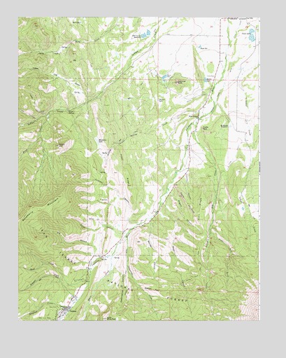
Cuchara, CO USGS Topographic Map
Click on map above to begin viewing in our Map Viewer.

This topographic map contains these locations and features:
Feature Name Type Latitude Longitude GNIS ID View Map
Barnes CanyonValleyN37.4156°W105.0571°192884View Map
Bend CreekStreamN37.3911°W105.0881°192868View Map
Big BranchStreamN37.4011°W105.0825°196843View Map
Big Branch Cucharas CreekStreamN37.4008°W105.0828°192881View Map
Black Hills TrailTrailN37.3972°W105.0297°192889View Map
Bonnett CreekStreamN37.3845°W105.0936°192867View Map
Butte DitchCanalN37.4770°W105.0422°192873View Map
Butte ReservoirReservoirN37.4754°W105.0493°192896View Map
Chaparral CreekStreamN37.4097°W105.0692°192888View Map
Coleman CanyonValleyN37.4186°W105.0584°192892View Map
Copper King CanyonValleyN37.4689°W105.0821°192864View Map
CucharaPopulated PlaceN37.3792°W105.1003°203635View Map
Cuchara Camps Post Office (historical)Post OfficeN37.3792°W105.1003°2026933View Map
Devils StairstepsRidgeN37.4239°W105.0378°192904View Map
Dodgeton CreekStreamN37.3795°W105.0961°192866View Map
Echo CanyonValleyN37.4505°W105.0338°192911View Map
Echo CreekStreamN37.4578°W105.0317°192910View Map
Echo DitchCanalN37.4417°W105.0136°192907View Map
Echo RidgeRidgeN37.4167°W105.0311°192890View Map
Fielden DamDamN37.4850°W105.0772°201202View Map
Fielden ReservoirReservoirN37.4850°W105.0772°201203View Map
Goemmer ButteSummitN37.4733°W105.0428°192872View Map
H R Carson Number 1 DamDamN37.4933°W105.0622°201230View Map
H R Carson Number 2 DamDamN37.4950°W105.0589°201500View Map
H R Carson ReservoirReservoirN37.4924°W105.0600°196840View Map
H R Carson Reservoir Number 1ReservoirN37.4936°W105.0618°201231View Map
H R Carson Reservoir Number 2ReservoirN37.4937°W105.0577°201501View Map
Hayes ReservoirReservoirN37.4881°W105.0306°192874View Map
Hope GulchValleyN37.4599°W105.1105°192869View Map
Huestes CanyonValleyN37.4358°W105.0387°192908View Map
Kruger MountainSummitN37.4467°W105.1039°192901View Map
La Veta Lake North DamDamN37.4933°W105.0039°201576View Map
La Veta Lake North ReservoirReservoirN37.4933°W105.0039°201577View Map
La Veta Lake South DamDamN37.4917°W105.0039°200214View Map
La Veta Town ReservoirReservoirN37.4913°W105.0043°200215View Map
Linscott MineMineN37.4614°W105.1133°192899View Map
Little Echo CreekStreamN37.4131°W105.0261°192903View Map
Magpie CanyonValleyN37.4279°W105.0458°192891View Map
Marker LakeReservoirN37.4741°W105.0281°192877View Map
McDonald ReservoirReservoirN37.4551°W105.0157°192909View Map
Mexican LakeLakeN37.4659°W105.0526°192897View Map
Mountain LakeLakeN37.4488°W105.0839°192894View Map
North White PeakSummitN37.3761°W105.0794°192886View Map
Piney RidgeRidgeN37.4375°W105.0697°192893View Map
Price CanyonValleyN37.4600°W105.1102°192862View Map
Price CreekStreamN37.4606°W105.1094°192863View Map
Profile RockPillarN37.4542°W105.0297°192905View Map
Rilling CanyonValleyN37.4552°W105.0525°192879View Map
Rilling CreekStreamN37.4603°W105.0267°192880View Map
Rock LakeLakeN37.4978°W105.0928°192900View Map
Sawtooth RockPillarN37.3878°W105.0553°192870View Map
Spanish Peaks DitchCanalN37.4750°W105.0172°192876View Map
Spanish Peaks MineMineN37.4103°W105.0978°1735114View Map
Sulphur SpringsSpringN37.4620°W105.0986°192898View Map
Three BridgesLocaleN37.4589°W105.0319°192878View Map
Town LakesReservoirN37.4906°W105.0028°192875View Map
Tracy CanyonValleyN37.4578°W105.1151°192865View Map
Vories CanyonValleyN37.4106°W105.0710°192882View Map
Wade CanyonValleyN37.4232°W105.0492°192871View Map
White CreekStreamN37.4017°W105.0767°192887View Map
Wonder MineMineN37.4970°W105.0978°1735115View Map

Note: Coordinates in the location and feature list above are referenced to NAD83 datum.


Copyright (C) 2008-2024 Ryan Niemi / Sunset Dynamics ... All Rights Reserved