TopoQuest Logo
Do you find TopoQuest useful?
Help keep TopoQuest running and adding new maps/features by donating!
Bitcoin:  19c7KJd3qBynnjoSw5npx9KScwjBe4ifkT
Litecoin:  LXs6TkuXGGXo1vDsWCkWVdjQX94eUKd6ui
Home View Maps Find Maps Find Places Resources & Links


Crater Lake East, Oregon Topographic Map

USGS Map Title: Crater Lake East, OR
USGS Map MRC: 42122H1
DRG (GeoTIFF) Download: o42122h1.tif


Neighboring USGS Topographic Map Quads:


  Pumice Desert West, OR  
43122A2
 

  Pumice Desert East, OR  
43122A1
 

  Welch Butte, OR  
43121A8
 

  Crater Lake West, OR  
42122H2
 

  Crater Lake East, OR  
42122H1
 

  Pothole Butte, OR  
42121H8
 

  Union Peak, OR  
42122G2
 

  Maklaks Crater, OR  
42122G1
 

  Sun Pass, OR  
42121G8


Map MRC Location:

N43°
W123°
N43°
W122°
H8 H7 H6 H5 H4 H3 H2 H1
G8 G7 G6 G5 G4 G3 G2 G1
F8 F7 F6 F5 F4 F3 F2 F1
E8 E7 E6 E5 E4 E3 E2 E1
D8 D7 D6 D5 D4 D3 D2 D1
C8 C7 C6 C5 C4 C3 C2 C1
B8 B7 B6 B5 B4 B3 B2 B1
A8 A7 A6 A5 A4 A3 A2 A1
N42°
W123°
N42°
W122°

Crater Lake East, OR USGS 1:24K Topographic Map Preview:
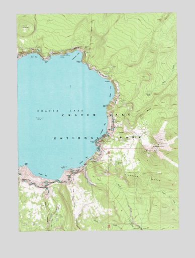
Crater Lake East, OR USGS Topographic Map
Click on map above to begin viewing in our Map Viewer.

This topographic map contains these locations and features:
Feature Name Type Latitude Longitude GNIS ID View Map
Anderson BluffsCliffN42.9043°W122.0322°1137194View Map
Anderson SpringSpringN42.9134°W122.0485°1137207View Map
Applegate PeakSummitN42.8998°W122.1050°1137278View Map
Base of Mount MazamaAreaN42.9507°W122.0497°1137551View Map
Bear Creek TrailTrailN42.9665°W122.0284°1137704View Map
Cascade SpringSpringN42.9527°W122.0220°1139423View Map
Castle RockPillarN42.9290°W122.0622°1154274View Map
Chaski BayBayN42.9091°W122.1039°1139585View Map
Cleetwood CoveBayN42.9744°W122.0802°1139816View Map
CloudcapSummitN42.9312°W122.0430°1158169View Map
Cloudcap BayBayN42.9346°W122.0600°1139842View Map
Crater LakeLakeN42.9420°W122.1064°1163669View Map
Danger BayBayN42.9175°W122.0750°1140614View Map
Dutton CliffCliffN42.9043°W122.0853°1141446View Map
Dutton RidgeRidgeN42.8999°W122.0848°1141447View Map
Dyar RockPillarN42.9012°W122.1156°1637904View Map
Eagle CragsSummitN42.9016°W122.1157°1141465View Map
Eagle PointCapeN42.9115°W122.1200°1141484View Map
Garfield PeakSummitN42.9040°W122.1234°1142578View Map
Garfield Peak TrailTrailN42.8932°W122.1192°1142579View Map
Grotto CoveBayN42.9549°W122.0559°1143115View Map
Grouse HillSummitN42.9925°W122.1213°1143128View Map
Kerr NotchGapN42.9124°W122.0717°1144572View Map
Kerr ValleyValleyN42.9016°W122.0532°1144573View Map
Lost Creek Ranger StationBuildingN42.8804°W122.0386°1132839View Map
Lost Creek Recreation SiteLocaleN42.8799°W122.0389°1156386View Map
Lost Creek SpringSpringN42.8852°W122.0502°1155202View Map
Mazama RockSummitN42.9832°W122.0734°1154306View Map
Mount MazamaSummitN42.9165°W122.0845°1163671View Map
Mount ScottSummitN42.9229°W122.0160°1149176View Map
Mount Scott LookoutLocaleN42.9235°W122.0159°1156385View Map
Mount Scott TrailTrailN42.9262°W122.0320°1146530View Map
Palisade PointCapeN42.9718°W122.0756°1147363View Map
PalisadesCliffN42.9637°W122.0595°1154312View Map
Phantom ShipIslandN42.9110°W122.0925°1147629View Map
Pumice CastleCliffN42.9290°W122.0575°1134046View Map
Pumice PointCapeN42.9726°W122.1050°1148040View Map
Redcloud CliffCliffN42.9368°W122.0509°1148343View Map
RoundtopSummitN42.9654°W122.0573°1148806View Map
Rugged CrestRidgeN42.9805°W122.0754°1132109View Map
Rugged Crest PalisadesCliffN42.9671°W122.0645°1148842View Map
Scott BluffsCliffN42.9412°W122.0275°1149166View Map
Sentinel RockPillarN42.9260°W122.0656°1149236View Map
Skell HeadCliffN42.9457°W122.0567°1149588View Map
Steel BayBayN42.9732°W122.1136°1150386View Map
Sun MeadowsFlatN42.8882°W122.0947°1150651View Map
Sun NotchGapN42.9026°W122.0970°1154335View Map
Sun Notch TrailTrailN42.8846°W122.0975°1150653View Map
Victor ViewCliffN42.9249°W122.0609°1639197View Map
Vidae CliffCliffN42.9015°W122.1006°1151761View Map
Vidae RidgeRidgeN42.8989°W122.1048°1151762View Map
WineglassCliffN42.9596°W122.0514°1152525View Map

Note: Coordinates in the location and feature list above are referenced to NAD83 datum.


Copyright (C) 2008-2024 Ryan Niemi / Sunset Dynamics ... All Rights Reserved