TopoQuest Logo
Do you find TopoQuest useful?
Help keep TopoQuest running and adding new maps/features by donating!
Bitcoin:  19c7KJd3qBynnjoSw5npx9KScwjBe4ifkT
Litecoin:  LXs6TkuXGGXo1vDsWCkWVdjQX94eUKd6ui
Home View Maps Find Maps Find Places Resources & Links


Cozahome, Arkansas Topographic Map

USGS Map Title: Cozahome, AR
USGS Map MRC: 36092A5
DRG (GeoTIFF) Download: o36092a5.tif


Neighboring USGS Topographic Map Quads:


  Yellville, AR  
36092B6
 

  Rea Valley, AR  
36092B5
 

  Buffalo City, AR  
36092B4
 

  Maumee, AR  
36092A6
 

  Cozahome, AR  
36092A5
 

  Big Flat, AR  
36092A4
 

  Marshall, AR  
35092H6
 

  Harriet, AR  
35092H5
 

  Landis, AR  
35092H4


Map MRC Location:

N37°
W93°
N37°
W92°
H8 H7 H6 H5 H4 H3 H2 H1
G8 G7 G6 G5 G4 G3 G2 G1
F8 F7 F6 F5 F4 F3 F2 F1
E8 E7 E6 E5 E4 E3 E2 E1
D8 D7 D6 D5 D4 D3 D2 D1
C8 C7 C6 C5 C4 C3 C2 C1
B8 B7 B6 B5 B4 B3 B2 B1
A8 A7 A6 A5 A4 A3 A2 A1
N36°
W93°
N36°
W92°

Cozahome, AR USGS 1:24K Topographic Map Preview:
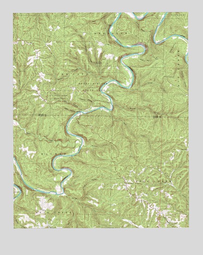
Cozahome, AR USGS Topographic Map
Click on map above to begin viewing in our Map Viewer.

This topographic map contains these locations and features:
Feature Name Type Latitude Longitude GNIS ID View Map
Assembly of God ChurchChurchN36.0256°W92.5460°69952View Map
Brantley FordCrossingN36.1090°W92.5168°70048View Map
Buffalo River State ParkParkN36.0809°W92.5716°47160View Map
Coon HollowValleyN36.0162°W92.5793°48001View Map
CozahomePopulated PlaceN36.0451°W92.5016°57596View Map
DeSoto CemeteryCemeteryN36.1081°W92.5949°48417View Map
Dog Leg ChuteChannelN36.1223°W92.5168°70055View Map
Dry Prong Spring CreekStreamN36.0167°W92.5821°48671View Map
Elm Springs CemeteryCemeteryN36.0878°W92.5160°48878View Map
Evening StarPopulated PlaceN36.0290°W92.5460°69958View Map
Fishtrap HollowValleyN36.0948°W92.5002°71617View Map
Harriet - Rock Creek Cosey Home Fire StationBuildingN36.0287°W92.5456°2116532View Map
Hickory CreekStreamN36.0592°W92.5002°71985View Map
Hogskin HollowValleyN36.0683°W92.5695°50179View Map
Indian RockhouseArchN36.0925°W92.5789°2571575View Map
Ingram CreekStreamN36.0817°W92.5413°50507View Map
Jim HollowValleyN36.0681°W92.5761°50650View Map
Jones HollowValleyN36.1002°W92.5345°50736View Map
Keystone (historical)Populated PlaceN36.1223°W92.5349°61027View Map
Kimball CreekStreamN36.0481°W92.5754°50841View Map
Little Panther CreekStreamN36.0878°W92.5635°51304View Map
Lonely HollowValleyN36.1112°W92.5074°51409View Map
MullPopulated PlaceN36.0776°W92.6054°61024View Map
Mull Church of ChristChurchN36.0773°W92.6060°77781View Map
Mull School (historical)SchoolN36.0767°W92.6132°81917View Map
Panther CreekStreamN36.0853°W92.5552°53151View Map
Panther HollowValleyN36.0862°W92.5557°61026View Map
Peter HollowValleyN36.0670°W92.5806°53300View Map
Petits ChuteChannelN36.1173°W92.5210°70066View Map
Pine Grove ChurchChurchN36.0009°W92.5996°53430View Map
Ralph - Caney Rural Fire ProtectionBuildingN36.1088°W92.6223°2117011View Map
Roaring RockBarN36.1101°W92.5029°70067View Map
Rock CreekStreamN36.0684°W92.5552°54090View Map
Rock Creek CemeteryCemeteryN36.0287°W92.5463°54096View Map
Rush CreekStreamN36.1240°W92.5491°54279View Map
Silver HollowValleyN36.1217°W92.5371°54848View Map
Silver Hollow ShoalBarN36.1212°W92.5349°70073View Map
Spring CreekStreamN36.0204°W92.5893°55097View Map
Sylvia (historical)Populated PlaceN36.1078°W92.6024°61025View Map
Township of De Soto (historical)CivilN36.0917°W92.6002°69632View Map
Township of Jefferson (historical)CivilN36.1223°W92.5668°69638View Map
Township of Maumee (historical)CivilN36.0542°W92.6168°69087View Map
Water CreekStreamN36.0498°W92.5766°56082View Map
Weast FordCrossingN36.1001°W92.5010°70078View Map

Note: Coordinates in the location and feature list above are referenced to NAD83 datum.


Copyright (C) 2008-2024 Ryan Niemi / Sunset Dynamics ... All Rights Reserved