TopoQuest Logo
Do you find TopoQuest useful?
Help keep TopoQuest running and adding new maps/features by donating!
Bitcoin:  19c7KJd3qBynnjoSw5npx9KScwjBe4ifkT
Litecoin:  LXs6TkuXGGXo1vDsWCkWVdjQX94eUKd6ui
Home View Maps Find Maps Find Places Resources & Links


Angus, New Mexico Topographic Map

USGS Map Title: Angus, NM
USGS Map MRC: 33105D6
DRG (GeoTIFF) Download: o33105d6.tif


Neighboring USGS Topographic Map Quads:


  Church Mountain, NM  
33105E7
 

  Nogal, NM  
33105E6
 

  Capitan, NM  
33105E5
 

  Nogal Peak, NM  
33105D7
 

  Angus, NM  
33105D6
 

  Fort Stanton, NM  
33105D5
 

  Sierra Blanca Peak, NM  
33105C7
 

  Ruidoso, NM  
33105C6
 

  Ruidoso Downs, NM  
33105C5


Map MRC Location:

N34°
W106°
N34°
W105°
H8 H7 H6 H5 H4 H3 H2 H1
G8 G7 G6 G5 G4 G3 G2 G1
F8 F7 F6 F5 F4 F3 F2 F1
E8 E7 E6 E5 E4 E3 E2 E1
D8 D7 D6 D5 D4 D3 D2 D1
C8 C7 C6 C5 C4 C3 C2 C1
B8 B7 B6 B5 B4 B3 B2 B1
A8 A7 A6 A5 A4 A3 A2 A1
N33°
W106°
N33°
W105°

Angus, NM USGS 1:24K Topographic Map Preview:
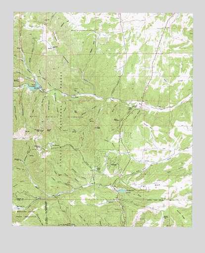
Angus, NM USGS Topographic Map
Click on map above to begin viewing in our Map Viewer.

This topographic map contains these locations and features:
Feature Name Type Latitude Longitude GNIS ID View Map
AltoPopulated PlaceN33.3987°W105.6808°903117View Map
Alto Lake DamDamN33.3934°W105.6672°923954View Map
Alto Post OfficePost OfficeN33.4059°W105.6752°937740View Map
Alto ReservoirReservoirN33.3962°W105.6739°903118View Map
Anan CanyonValleyN33.4712°W105.7425°903144View Map
AngusPopulated PlaceN33.4454°W105.6655°1986627View Map
Angus CanyonValleyN33.4467°W105.6603°903172View Map
Bear CanyonValleyN33.4545°W105.7311°903624View Map
BonitoPopulated PlaceN33.4506°W105.7089°923566View Map
Bonito DamDamN33.4559°W105.7317°924031View Map
Bonito LakeReservoirN33.4554°W105.7360°904000View Map
Bonito Post Office (historical)Post OfficeN33.4506°W105.7089°937215View Map
Bonito Volunteer Fire Department Angus Canyon StationBuildingN33.4479°W105.6682°2658219View Map
Bonito Volunteer Fire Department Copper Canyon StationBuildingN33.4474°W105.6606°2658218View Map
Bonito Volunteer Fire Department Main StationBuildingN33.4072°W105.6748°2657622View Map
Buck MountainSummitN33.4373°W105.6803°904132View Map
Carlton CanyonValleyN33.4004°W105.7361°904781View Map
Cedar Creek TrailTrailN33.3876°W105.7180°904868View Map
ChristmasMineN33.4570°W105.7467°916226View Map
Church of the NazareneChurchN33.3987°W105.6808°920288View Map
Coal Mine CanyonValleyN33.4129°W105.6525°905222View Map
Coyote MesaSummitN33.4337°W105.6561°905476View Map
Creek Lead ClaimMineN33.4581°W105.7178°916959View Map
Crest TrailTrailN33.4270°W105.7450°905498View Map
Crocket CanyonValleyN33.4492°W105.6817°905511View Map
Divine Guidance Number TwoMineN33.4334°W105.7197°916961View Map
Dry Mills TrailTrailN33.4273°W105.7014°905890View Map
Eagle Creek LodgeLocaleN33.4140°W105.7458°905930View Map
Eagle LakeReservoirN33.3861°W105.7470°905933View Map
Ferguson CanyonValleyN33.4867°W105.6875°906258View Map
Flume CanyonValleyN33.3981°W105.7025°906312View Map
Fox SpringSpringN33.4359°W105.7292°1986628View Map
Fox Spring CanyonValleyN33.4523°W105.7250°906366View Map
Fred CanyonValleyN33.4509°W105.7028°906385View Map
Gavilan RidgeRidgeN33.3823°W105.6330°906511View Map
George CanyonValleyN33.4667°W105.7389°906516View Map
Gilmore CanyonValleyN33.3995°W105.6933°906550View Map
Granite KnobSummitN33.4312°W105.7272°906686View Map
Grapevine CanyonValleyN33.4990°W105.7022°906699View Map
High MesaSummitN33.3990°W105.6547°906973View Map
Hope ProspectMineN33.4623°W105.7333°915410View Map
Hubbard CanyonValleyN33.4004°W105.7150°907134View Map
Jackson CanyonValleyN33.4492°W105.6892°907290View Map
Johnson CanyonValleyN33.4087°W105.7403°907407View Map
Krause CanyonValleyN33.3965°W105.7072°907590View Map
Kraut CanyonValleyN33.4598°W105.7355°907591View Map
KWES-FM (Ruidoso)TowerN33.3867°W105.6711°938768View Map
Lamay RanchLocaleN33.4651°W105.6792°913308View Map
Little Creek SpringSpringN33.4215°W105.7315°908010View Map
Littleton CanyonValleyN33.4598°W105.7353°908075View Map
Loma GrandeSummitN33.4842°W105.7203°908130View Map
Loma Grande RanchLocaleN33.4798°W105.7233°1986626View Map
Loma Grande RanchLocaleN33.4798°W105.7236°908131View Map
Mayberry MineMineN33.4681°W105.7055°914808View Map
McCrory ProspectMineN33.3823°W105.7044°914809View Map
Mills CanyonValleyN33.4490°W105.6864°908763View Map
Mills PeakSummitN33.4329°W105.6922°908767View Map
Mineral Farm ProspectMineN33.4617°W105.7272°914810View Map
Mineral Farms CanyonValleyN33.4545°W105.7228°908791View Map
Monjeau CampgroundLocaleN33.4320°W105.7300°924230View Map
Monjeau LookoutLocaleN33.3987°W105.6808°935892View Map
Monjeau Number 1 ClaimMineN33.4581°W105.7178°914812View Map
Monjeau PeakSummitN33.4309°W105.7317°908837View Map
Nolton CanyonValleyN33.4517°W105.7144°909116View Map
North Eagle TrailTrailN33.4217°W105.7408°909135View Map
Oak Grove CampgroundLocaleN33.3962°W105.7467°913306View Map
Oso ClaimMineN33.4581°W105.7178°916968View Map
Peters CanyonValleyN33.4479°W105.6636°909588View Map
Philadelphia CanyonValleyN33.4512°W105.6944°909599View Map
Phillips CanyonValleyN33.3992°W105.6961°909601View Map
Rock Number OneMineN33.4442°W105.7444°916155View Map
Rodamaker CanyonValleyN33.4573°W105.7417°910412View Map
Ruidoso ReservoirReservoirN33.3806°W105.6456°910470View Map
Salt PeakSummitN33.4420°W105.7083°910576View Map
Schoolhouse CanyonValleyN33.4542°W105.7211°910872View Map
Sierra VistaPopulated PlaceN33.4090°W105.6930°911042View Map
Silver Plume MineMineN33.4015°W105.7114°916162View Map
Skinner CanyonValleyN33.4481°W105.6775°911118View Map
Skyline CampgroundLocaleN33.4198°W105.7339°1986629View Map
Skyline CampgroundLocaleN33.4201°W105.7344°913307View Map
SoldierMineN33.4606°W105.7464°916165View Map
South Fork Eagle CreekStreamN33.3926°W105.7244°911233View Map
Spring CanyonValleyN33.4540°W105.7247°911315View Map
Sun ValleyPopulated PlaceN33.4123°W105.6825°911485View Map
Telephone CanyonValleyN33.4117°W105.7430°911592View Map
The Church of Latter Day SaintsChurchN33.3987°W105.6808°920247View Map
Trick TankReservoirN33.4957°W105.6608°1986625View Map
Vickers CanyonValleyN33.4142°W105.6630°912099View Map
Villa MadonnaPopulated PlaceN33.4226°W105.7236°912109View Map
Water Dog ProspectMineN33.4745°W105.7497°916178View Map
Wet Mills TrailTrailN33.4312°W105.7122°912280View Map
Yours Truly ClaimMineN33.4456°W105.7489°914776View Map

Note: Coordinates in the location and feature list above are referenced to NAD83 datum.


Copyright (C) 2008-2024 Ryan Niemi / Sunset Dynamics ... All Rights Reserved