TopoQuest Logo
Do you find TopoQuest useful?
Help keep TopoQuest running and adding new maps/features by donating!
Bitcoin:  19c7KJd3qBynnjoSw5npx9KScwjBe4ifkT
Litecoin:  LXs6TkuXGGXo1vDsWCkWVdjQX94eUKd6ui
Home View Maps Find Maps Find Places Resources & Links


Cowlesville, New York Topographic Map

USGS Map Title: Cowlesville, NY
USGS Map MRC: 42078G4
DRG (GeoTIFF) Download: o42078g4.tif


Neighboring USGS Topographic Map Quads:


  East Aurora, NY  
42078G5
 

  Cowlesville, NY  
42078G4
 

  Attica, NY  
42078G3
 

  Holland, NY  
42078F5
 

  Strykersville, NY  
42078F4
 

  Johnsonburg, NY  
42078F3


Map MRC Location:

N43°
W79°
N43°
W78°
H8 H7 H6 H5 H4 H3 H2 H1
G8 G7 G6 G5 G4 G3 G2 G1
F8 F7 F6 F5 F4 F3 F2 F1
E8 E7 E6 E5 E4 E3 E2 E1
D8 D7 D6 D5 D4 D3 D2 D1
C8 C7 C6 C5 C4 C3 C2 C1
B8 B7 B6 B5 B4 B3 B2 B1
A8 A7 A6 A5 A4 A3 A2 A1
N42°
W79°
N42°
W78°

Cowlesville, NY USGS 1:24K Topographic Map Preview:
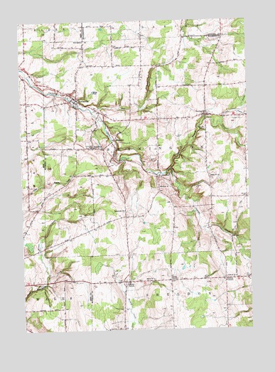
Cowlesville, NY USGS Topographic Map
Click on map above to begin viewing in our Map Viewer.

This topographic map contains these locations and features:
Feature Name Type Latitude Longitude GNIS ID View Map
Bender CreekStreamN42.7723°W78.4859°943655View Map
BenningtonPopulated PlaceN42.8370°W78.3975°943693View Map
Bennington Volunteer Fire CompanyBuildingN42.8370°W78.3944°2700817View Map
Camp SchoellkopfLocaleN42.8137°W78.4178°945659View Map
CowlesvillePopulated PlaceN42.8434°W78.4689°947602View Map
Cowlesville Baptist ChurchChurchN42.8421°W78.4688°2615826View Map
Cowlesville CemeteryCemeteryN42.8456°W78.4682°2515209View Map
Cowlesville Fire CompanyBuildingN42.8404°W78.4600°2701227View Map
Fairview CemeteryCemeteryN42.8357°W78.3791°949833View Map
Fenton CreekStreamN42.8384°W78.3820°949974View Map
Fisher AirportAirportN42.7892°W78.4768°978348View Map
FolsomdalePopulated PlaceN42.8273°W78.4481°950361View Map
Folsomdale Baptist ChurchChurchN42.8138°W78.4508°2616029View Map
Folsomdale CemeteryCemeteryN42.8239°W78.4611°950362View Map
French BrookStreamN42.8337°W78.3889°950684View Map
Gillett CreekStreamN42.8337°W78.3889°951120View Map
Harris CornersPopulated PlaceN42.7698°W78.4420°952262View Map
Harris Corners Fire DepartmentBuildingN42.7707°W78.4443°2701001View Map
Hedges CemeteryCemeteryN42.7717°W78.4514°2515212View Map
Ironwood Golf CourseLocaleN42.7818°W78.4494°2615419View Map
Maple Lawn CemeteryCemeteryN42.8309°W78.3984°956435View Map
Matts PondReservoirN42.8464°W78.4597°956686View Map
North SheldonPopulated PlaceN42.7701°W78.4186°958917View Map
Persons CornersPopulated PlaceN42.7703°W78.3886°960220View Map
Persons Pioneer CemeteryCemeteryN42.7704°W78.4003°960219View Map
Red BrookStreamN42.8387°W78.4603°962270View Map
Right Branch Cayuga CreekStreamN42.8145°W78.4192°962521View Map
Sacred Heart CemeteryCemeteryN42.8361°W78.3997°2515210View Map
Sacred Heart Roman Catholic ChurchChurchN42.8364°W78.3994°2515211View Map
Salem United Church of ChristChurchN42.8373°W78.3966°2617054View Map
Schoellkopf Road BridgeBridgeN42.8186°W78.4458°2614983View Map
School Number 1 (historical)SchoolN42.8372°W78.3939°2100535View Map
School Number 12 (historical)SchoolN42.8078°W78.4245°975034View Map
School Number 14 (historical)SchoolN42.8120°W78.3964°975087View Map
School Number 18 (historical)SchoolN42.8142°W78.3758°2100536View Map
School Number 19 (historical)SchoolN42.7984°W78.4434°975155View Map
School Number 20 (historical)SchoolN42.8239°W78.4550°975217View Map
School Number 4 (historical)SchoolN42.7692°W78.4897°975347View Map
School Number 4 (historical)SchoolN42.7706°W78.3842°975348View Map
School Number 5 (historical)SchoolN42.7701°W78.4281°975417View Map
Sheldon Airstrip (historical)AirportN42.7589°W78.3920°978296View Map
Town of BenningtonCivilN42.8246°W78.3968°978722View Map
Treichler Farm AirportAirportN42.7623°W78.4962°2443111View Map
WNYB-TV (Buffalo)TowerN42.7828°W78.4575°978626View Map

Note: Coordinates in the location and feature list above are referenced to NAD83 datum.


Copyright (C) 2008-2024 Ryan Niemi / Sunset Dynamics ... All Rights Reserved