TopoQuest Logo
Do you find TopoQuest useful?
Help keep TopoQuest running and adding new maps/features by donating!
Bitcoin:  19c7KJd3qBynnjoSw5npx9KScwjBe4ifkT
Litecoin:  LXs6TkuXGGXo1vDsWCkWVdjQX94eUKd6ui
Home View Maps Find Maps Find Places Resources & Links


Cove Creek, Virginia Topographic Map

USGS Map Title: Cove Creek, VA
USGS Map MRC: 37081B3
DRG (GeoTIFF) Download: o37081b3.tif


Neighboring USGS Topographic Map Quads:


  Anawalt, WV  
37081C4
 

  Bramwell, WV  
37081C3
 

  Bluefield, WV  
37081C2
 

  Tiptop, VA  
37081B4
 

  Cove Creek, VA  
37081B3
 

  Bastian, VA  
37081B2
 

  Hutchinson Rock, VA  
37081A4
 

  Garden Mountain, VA  
37081A3
 

  Big Bend, VA  
37081A2


Map MRC Location:

N38°
W82°
N38°
W81°
H8 H7 H6 H5 H4 H3 H2 H1
G8 G7 G6 G5 G4 G3 G2 G1
F8 F7 F6 F5 F4 F3 F2 F1
E8 E7 E6 E5 E4 E3 E2 E1
D8 D7 D6 D5 D4 D3 D2 D1
C8 C7 C6 C5 C4 C3 C2 C1
B8 B7 B6 B5 B4 B3 B2 B1
A8 A7 A6 A5 A4 A3 A2 A1
N37°
W82°
N37°
W81°

Cove Creek, VA USGS 1:24K Topographic Map Preview:
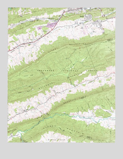
Cove Creek, VA USGS Topographic Map
Click on map above to begin viewing in our Map Viewer.

This topographic map contains these locations and features:
Feature Name Type Latitude Longitude GNIS ID View Map
Bluefield Industrial ParkLocaleN37.2348°W81.3020°1497606View Map
Bluefield Police DepartmentBuildingN37.2342°W81.2634°2766965View Map
Bluestone School (historical)SchoolN37.2171°W81.3573°1497608View Map
Buckhorn MountainSummitN37.1785°W81.3301°1492658View Map
Burkes Garden CreekStreamN37.1354°W81.3626°1482172View Map
Calvary Church (historical)ChurchN37.1768°W81.2968°1497613View Map
Camp JoyLocaleN37.2123°W81.3623°1482261View Map
Carter BranchStreamN37.1485°W81.2576°1482339View Map
Chestnut Grove ChurchChurchN37.1543°W81.3529°1482476View Map
Chestnut RidgeRidgeN37.1862°W81.3498°1482497View Map
Clear Spring BranchStreamN37.1523°W81.2504°1482568View Map
Clearfork Volunteer Fire DepartmentBuildingN37.1750°W81.3021°2085875View Map
College Plaza Shopping CenterLocaleN37.2404°W81.2518°1497624View Map
Cove CreekStreamN37.1768°W81.2943°1482735View Map
Cove CreekPopulated PlaceN37.1782°W81.2934°1492811View Map
Crabtree GapGapN37.1510°W81.3279°1482796View Map
Deavers BranchStreamN37.1523°W81.2532°1482962View Map
Dills SpringSpringN37.2312°W81.2868°1483014View Map
Doe Hollow GapGapN37.1751°W81.3459°1690060View Map
Dudley Primary SchoolSchoolN37.2477°W81.2935°1483154View Map
East Fork Cove CreekStreamN37.1865°W81.3048°1483205View Map
Eastern DistrictCivilN37.2103°W81.3368°1927311View Map
Ebenezer ChurchChurchN37.2229°W81.3354°1483231View Map
Fairview School (historical)SchoolN37.1548°W81.3482°1497631View Map
Fincastle Country ClubLocaleN37.2276°W81.2765°1491148View Map
First Assembly Christian SchoolSchoolN37.2481°W81.2972°2498478View Map
Gose KnobSummitN37.1354°W81.3115°1483715View Map
Gose MillPopulated PlaceN37.1251°W81.3559°1493551View Map
Gose Mill DamDamN37.1251°W81.3565°1490981View Map
Gospel HallChurchN37.2368°W81.2657°1483720View Map
Gospel MissionChurchN37.2390°W81.3412°1483722View Map
Graham High SchoolSchoolN37.2377°W81.2710°1483738View Map
Graham Middle SchoolSchoolN37.2357°W81.2615°1497649View Map
Grandview Memory GardensCemeteryN37.2284°W81.3282°1483740View Map
Hemppatch BranchStreamN37.1501°W81.2929°1484031View Map
Indianfield BranchStreamN37.1451°W81.2745°1484339View Map
Kidd BranchStreamN37.1451°W81.2745°1484583View Map
Kinzers Church (historical)ChurchN37.1521°W81.3645°1497668View Map
Little CreekStreamN37.1354°W81.3626°1484891View Map
Maple Hill CemeteryCemeteryN37.2459°W81.3012°1485173View Map
Mudley BranchStreamN37.1790°W81.3454°1485746View Map
Nye CoveBayN37.1865°W81.3048°1485930View Map
Oneida BranchStreamN37.1846°W81.3298°1485978View Map
Parkview ChurchChurchN37.2365°W81.2870°1486069View Map
Perry BranchStreamN37.1707°W81.3184°1486148View Map
Richwood Golf ClubLocaleN37.2385°W81.2901°1491237View Map
Saint ClairPopulated PlaceN37.2382°W81.3193°1493519View Map
Saint Clair School (historical)SchoolN37.2326°W81.3182°1497727View Map
Saint Lukes CemeteryCemeteryN37.2454°W81.3051°1497728View Map
SamPopulated PlaceN37.2398°W81.3409°1493523View Map
Scott KnobSummitN37.2418°W81.3609°1493532View Map
ShannandalePopulated PlaceN37.2146°W81.3620°1493543View Map
Shawver MillPopulated PlaceN37.1534°W81.3537°1493572View Map
Stony RidgeRidgeN37.2468°W81.3357°1487628View Map
The GapGapN37.1260°W81.3568°1487826View Map
Town of BluefieldCivilN37.2353°W81.2745°2390737View Map
Twin City Shopping CenterLocaleN37.2426°W81.2651°1497757View Map
Valley Vista CemeteryCemeteryN37.2207°W81.3507°1488102View Map
Virginia Avenue United Methodist ChurchChurchN37.2487°W81.2943°1497758View Map
Wagner Trace BranchStreamN37.1485°W81.2812°1488147View Map
West Fork Cove CreekStreamN37.1865°W81.3048°1488252View Map
West GrahamPopulated PlaceN37.2473°W81.3034°1497760View Map
Wrights ValleyValleyN37.2410°W81.3272°1487097View Map
Wrights Valley ChurchChurchN37.2393°W81.3251°1487098View Map
Wrights Valley CreekStreamN37.2493°W81.2873°1487099View Map

Note: Coordinates in the location and feature list above are referenced to NAD83 datum.


Copyright (C) 2008-2024 Ryan Niemi / Sunset Dynamics ... All Rights Reserved