TopoQuest Logo
Do you find TopoQuest useful?
Help keep TopoQuest running and adding new maps/features by donating!
Bitcoin:  19c7KJd3qBynnjoSw5npx9KScwjBe4ifkT
Litecoin:  LXs6TkuXGGXo1vDsWCkWVdjQX94eUKd6ui
Home View Maps Find Maps Find Places Resources & Links


Corydon East, Indiana Topographic Map

USGS Map Title: Corydon East, IN
USGS Map MRC: 38086B1
DRG (GeoTIFF) Download: o38086b1.tif


Neighboring USGS Topographic Map Quads:


  Depauw, IN  
38086C2
 

  Crandall, IN  
38086C1
 

  Georgetown, IN  
38085C8
 

  Corydon West, IN  
38086B2
 

  Corydon East, IN  
38086B1
 

  Lanesville, IN  
38085B8
 

  Mauckport, IN  
38086A2
 

  Laconia, IN  
38086A1
 

  Kosmosdale, KY  
38085A8


Map MRC Location:

N39°
W87°
N39°
W86°
H8 H7 H6 H5 H4 H3 H2 H1
G8 G7 G6 G5 G4 G3 G2 G1
F8 F7 F6 F5 F4 F3 F2 F1
E8 E7 E6 E5 E4 E3 E2 E1
D8 D7 D6 D5 D4 D3 D2 D1
C8 C7 C6 C5 C4 C3 C2 C1
B8 B7 B6 B5 B4 B3 B2 B1
A8 A7 A6 A5 A4 A3 A2 A1
N38°
W87°
N38°
W86°

Corydon East, IN USGS 1:24K Topographic Map Preview:
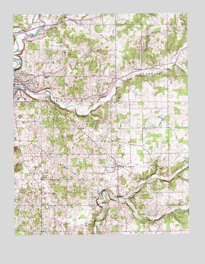
Corydon East, IN USGS Topographic Map
Click on map above to begin viewing in our Map Viewer.

This topographic map contains these locations and features:
Feature Name Type Latitude Longitude GNIS ID View Map
BreckenridgePopulated PlaceN38.2178°W86.0330°431467View Map
Brush Heap CreekStreamN38.2390°W86.1066°431685View Map
Cedar Hill CemeteryCemeteryN38.2165°W86.1205°432274View Map
CorydonPopulated PlaceN38.2120°W86.1219°433003View Map
Corydon Country ClubLocaleN38.2026°W86.0991°452296View Map
Corydon Water Works Dam Number 1DamN38.2219°W86.1195°433301View Map
Corydon Water Works Dam Number 2DamN38.2377°W86.1098°433302View Map
Grable SpringSpringN38.2297°W86.1184°435254View Map
Greenridge RLA AirportAirportN38.2396°W86.0157°449244View Map
Harrison CountyCivilN38.1951°W86.1113°451677View Map
Harrison Grange (historical)Populated PlaceN38.2153°W86.1022°435788View Map
HillcrestPopulated PlaceN38.2037°W86.1186°436196View Map
Kings StorePopulated PlaceN38.2037°W86.0611°452238View Map
Lake Number OneReservoirN38.2251°W86.1200°447082View Map
Lake Number TwoReservoirN38.2385°W86.1119°447421View Map
Middle Fork Buck CreekStreamN38.1445°W86.0452°439095View Map
Miles SpringSpringN38.2366°W86.1140°439137View Map
Musselman CemeteryCemeteryN38.1459°W86.0658°439906View Map
New MiddletownPopulated PlaceN38.1640°W86.0508°440086View Map
New Middletown Elementary SchoolSchoolN38.1640°W86.0472°447067View Map
New Middletown Volunteer Fire DepartmentBuildingN38.1632°W86.0496°2625604View Map
Pfrimmer ChurchChurchN38.2073°W86.0511°441074View Map
Pleasant Ridge ChurchChurchN38.1578°W86.1050°441300View Map
Saint Peters ChurchChurchN38.1903°W86.0180°442808View Map
Salem ChurchChurchN38.1470°W86.0502°442926View Map
Sharon CemeteryCemeteryN38.1576°W86.0308°443294View Map
Shuck CemeteryCemeteryN38.2076°W86.0966°443462View Map
Sulphur SpringSpringN38.2042°W86.1050°447936View Map
Town of New MiddletownCivilN38.1645°W86.0510°2396804View Map
Township of FranklinCivilN38.2352°W86.0060°453303View Map
Township of WebsterCivilN38.1413°W86.0538°454044View Map

Note: Coordinates in the location and feature list above are referenced to NAD83 datum.


Copyright (C) 2008-2024 Ryan Niemi / Sunset Dynamics ... All Rights Reserved