TopoQuest Logo
Do you find TopoQuest useful?
Help keep TopoQuest running and adding new maps/features by donating!
Bitcoin:  19c7KJd3qBynnjoSw5npx9KScwjBe4ifkT
Litecoin:  LXs6TkuXGGXo1vDsWCkWVdjQX94eUKd6ui
Home View Maps Find Maps Find Places Resources & Links


Correo, New Mexico Topographic Map

USGS Map Title: Correo, NM
USGS Map MRC: 34107H2
DRG (GeoTIFF) Download: o34107h2.tif


Neighboring USGS Topographic Map Quads:


  Mesita, NM  
35107A3
 

  Mesa Gigante, NM  
35107A2
 

  Canoncito School, NM  
35107A1
 

  Dough Mountain, NM  
34107H3
 

  Correo, NM  
34107H2
 

  South Garcia, NM  
34107H1
 

  Cerro Verde, NM  
34107G3
 

  White Ridge, NM  
34107G2
 

  South Garcia SE, NM  
34107G1


Map MRC Location:

N35°
W108°
N35°
W107°
H8 H7 H6 H5 H4 H3 H2 H1
G8 G7 G6 G5 G4 G3 G2 G1
F8 F7 F6 F5 F4 F3 F2 F1
E8 E7 E6 E5 E4 E3 E2 E1
D8 D7 D6 D5 D4 D3 D2 D1
C8 C7 C6 C5 C4 C3 C2 C1
B8 B7 B6 B5 B4 B3 B2 B1
A8 A7 A6 A5 A4 A3 A2 A1
N34°
W108°
N34°
W107°

Correo, NM USGS 1:24K Topographic Map Preview:
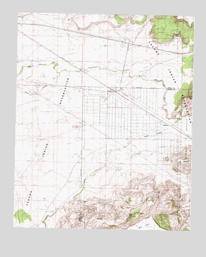
Correo, NM USGS Topographic Map
Click on map above to begin viewing in our Map Viewer.

This topographic map contains these locations and features:
Feature Name Type Latitude Longitude GNIS ID View Map
Arroyo ColoradoStreamN34.9631°W107.2198°897631View Map
Arroyo LuceroStreamN34.9431°W107.1298°897647View Map
CorreoPopulated PlaceN34.9550°W107.1848°923586View Map
Coyote SpringSpringN34.9870°W107.1370°888028View Map
East TankReservoirN34.8970°W107.1489°888717View Map
Highland Meadows Census Designated PlaceCensusN34.9400°W107.1655°2584110View Map
Highland Meadows Volunteer Fire DepartmentBuildingN34.9487°W107.1608°2658022View Map
Lower T X RanchLocaleN34.9150°W107.1861°891455View Map
Marys WindmillLocaleN34.9420°W107.1689°891667View Map
McGaughys WindmillLocaleN34.9137°W107.1761°891758View Map
Mesa RedondaSummitN34.9145°W107.1345°898037View Map
Middle TankReservoirN34.8836°W107.1686°891984View Map
Millet WindmillLocaleN34.8998°W107.1987°892069View Map
RWP-15 Water WellWellN34.9912°W107.1725°918541View Map
SuwaneePopulated PlaceN34.9350°W107.1373°923697View Map
Suwanee SpringSpringN34.9417°W107.1325°895449View Map
Tank Number 3ReservoirN34.8753°W107.1999°898142View Map
Tranquilino WindmillLocaleN34.9762°W107.1734°895799View Map
Valentine TankReservoirN34.8906°W107.2012°896075View Map
Windmill Number 10LocaleN34.9020°W107.2484°898201View Map

Note: Coordinates in the location and feature list above are referenced to NAD83 datum.


Copyright (C) 2008-2024 Ryan Niemi / Sunset Dynamics ... All Rights Reserved